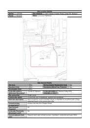
Site Location Details Ref No LDF173 Site Address Land to south ...
Site Location Details Ref No LDF173 Site Address Land to south ...
Site Location Details Ref No LDF173 Site Address Land to south ...

Create successful ePaper yourself
Turn your PDF publications into a flip-book with our unique Google optimized e-Paper software.
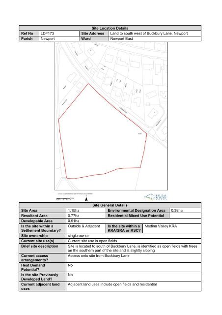
<strong>Site</strong> <strong>Location</strong> <strong>Details</strong><strong>Ref</strong> <strong>No</strong> <strong>LDF173</strong> <strong>Site</strong> <strong>Address</strong> <strong>Land</strong> <strong>to</strong> <strong>south</strong> west of Buckbury Lane, NewportParish Newport Ward Newport East<strong>Site</strong> General <strong>Details</strong><strong>Site</strong> Area 1.15ha Environmental Designation Area 0.38haResultant Area 0.77ha Residential Mixed Use PotentialDevelopable Area 0.51haIs the site within a Outside & Adjacent Is the site within a Medina Valley KRASettlement Boundary?KRA/SRA or RSC?<strong>Site</strong> ownershipsingle ownerCurrent site use(s) Current site use is open fieldsBrief site description <strong>Site</strong> is located <strong>to</strong> <strong>south</strong> of Buckbury Lane, is identified as open fields with treeson the <strong>south</strong>ern part of the site and is slightly slopingCurrent accessAccess on<strong>to</strong> site from Buckbury Lanearrangements?Heat Demand<strong>No</strong>Potential?Is the site Previously <strong>No</strong>Developed <strong>Land</strong>?Current adjacent land Adjacent land uses include open fields and residentialuses
Summary of relevantprevious applications/uses on the siteIs the site or adjacentland covered by anyallocations?Is the site or landimmediately adjacent <strong>to</strong>it subject <strong>to</strong> anydesignations?Planning His<strong>to</strong>ry<strong>No</strong>neCurrent Planning Status<strong>Site</strong> = <strong>No</strong>neAdjacent site = <strong>No</strong>ne<strong>Site</strong> = EA flood zones 2 and 3 on approx. 30% of the siteAdjacent site = <strong>No</strong> designationTPO details on site = TPO/1991/10 Group Order G1 on a small part of the siteIs the site or landimmediately adjacent <strong>to</strong>it subject <strong>to</strong> anypotential designations?Proposed use for thesiteTPO details on adjacent site = TPO/1991/10 Group Order G1 <strong>to</strong> west of siteArchaeological details = <strong>No</strong>nePotential Planning Status<strong>No</strong>HousingTheoretical site yield 15-26range (units)Likely site yield (units) 20Likely infrastructurerequirements for thesitePotential impact on thesurrounding ofdevelopmentPotential mitigationrequired<strong>Site</strong> Proposal<strong>Site</strong> Capacity Assessment<strong>Site</strong> adjacent <strong>to</strong> existing utility connections and considered likely thatconnections can be made.There are trees on and adjacent <strong>to</strong> the site which are protected by a GroupOrder and any development may adversely impact upon themEnsure an appropriate buffer zone is put in place <strong>to</strong> mitigate the potentialimpact on these trees<strong>Site</strong> Assessment Conclusions<strong>Site</strong> is within a Key Regeneration Area, with existing access which requires a small amount of improvementand one owner<strong>Site</strong> StatusTherefore the site iscurrently considered <strong>to</strong>be:DeliverableDevelopable<strong>No</strong>t Currently DevelopableX