Woman Lake - Cass County, Minnesota
Woman Lake - Cass County, Minnesota
Woman Lake - Cass County, Minnesota

Create successful ePaper yourself
Turn your PDF publications into a flip-book with our unique Google optimized e-Paper software.
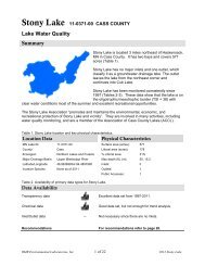
<strong>Woman</strong> <strong>Lake</strong> 11-0201-00 CASS COUNTYSummary<strong>Woman</strong> <strong>Lake</strong> is located about three miles west of the city of Longville, MN in<strong>Cass</strong> <strong>County</strong>. It covers 5,520 acres, which places it in the upper 5% of lakes in<strong>Minnesota</strong> in terms of size.<strong>Woman</strong> <strong>Lake</strong> is part of a chain of lakes along the Boy River. The Boy Riverenters the west side of <strong>Woman</strong> <strong>Lake</strong> from Child <strong>Lake</strong> and exits on the east sideinto Girl <strong>Lake</strong> and then continues north to Leech <strong>Lake</strong>. The Leech <strong>Lake</strong> Riverexits Leech <strong>Lake</strong> and flows east to join the Mississippi River.<strong>Woman</strong> <strong>Lake</strong> includes a central basin and several large bays. Broadwater Bay at the north end ofthe lake is the largest bay with an area of about 1,000 acres (including channel to main basin).Water quality data have been collected on <strong>Woman</strong> <strong>Lake</strong> and Broadwater Bay since 1987. Thesedata show that the lake is mesotrophic (page 9). Mesotrophic <strong>Lake</strong>s are excellent for recreationand fishing and have clear water with occasional algae blooms in late summer.The <strong>Woman</strong> <strong>Lake</strong> Property Owners Association was established in 1976. In 1978, Child and Girl<strong>Lake</strong> Property Owners joined the Association. Their mission is to promote the improvement ofliving, recreational, environmental and ecological conditions on lakes and waterways served by theAssociation. The Association has been involved in numerous activities including water safety,wetland conservation, land conservation, fish management, pollution, land use controls, publicaccess policies and property taxes, water quality monitoring, education, Healthy <strong>Lake</strong>s Initiative,and is a member of the Association of <strong>Cass</strong> <strong>County</strong> <strong>Lake</strong>s (ACCL).VitalsMN <strong>Lake</strong> ID: 11-0201-00<strong>County</strong>:<strong>Cass</strong>Ecoregion: Northern <strong>Lake</strong>s and ForestMajor DrainageBasin:Upper Mississippi RiverLatitude/Longitude: 46.94864369/-94.28222869Water Body Type: PublicMonitored Sites(Primary):Monitored Sites(Secondary):Invasive species:Data AvailabilityTransparency dataChemical dataInlet/Outlet data<strong>Woman</strong>: 201, 207Broadwater: 102<strong>Woman</strong>: 202, 203, 205, 206Broadwater: 204none documentedPhysical CharacteristicsSurface area (acres): 5,520Littoral area (acres): 1,953% Littoral area: 35%Max depth (ft): 54 (m): 16.5Mean depth (ft): 17.8 (m): 5.4<strong>Lake</strong>shed size (acres): 12,652<strong>Lake</strong>shed : lake area ratio 2.3:1Inlets2 – Boy River andBlackwater CreekOutlets1 – Boy RiverAccesses2 publicNumerous yearly secchi readings from 1987-2008through the MPCA CLMP program.Total Phosphorus and Chlorophyll a data have beencollected in 1988, 2004 and 2008.No inlet or outlet monitoring has been conducted.Recommendations For recommendations refer to page 12.<strong>Woman</strong> <strong>Lake</strong> and Broadwater Bay Report generation: 2008, RMB Environmental Laboratories 1 of 12
Figure 1. Map of Wabedo <strong>Lake</strong> illustrating bathymetry, lake sample site locations, stream inlets and outletsand aerial land use. The pink shaded areas in the lake illustrate the littoral zone, where the sunlight canusually reach the lake bottom allowing aquatic plants to grow.Basin <strong>Lake</strong> Site Depth (ft) Monitoring Programs<strong>Woman</strong> 103 36 MPCA: 1988, 2004<strong>Woman</strong> 201 50 CLMP: 1987-2004; MPCA: 1988, 2004; Outdoor Corps: 2004<strong>Woman</strong> 202 55 CLMP: 1987-1998; MPCA: 1988, 2004<strong>Woman</strong> 203 30 CLMP: 1988-1998<strong>Woman</strong> 205 35 CLMP: 1988, 1993-2003<strong>Woman</strong> 206 35 CLMP: 2004-2007<strong>Woman</strong> 207 64 CLMP: 2005-2008; RMB Lab: 2008Broadwater 102 44 MPCA: 1988, 2004; RMB Lab: 2008Broadwater 204 50 CLMP: 1988-2003<strong>Woman</strong> <strong>Lake</strong> and Broadwater Bay Report generation: 2008, RMB Environmental Laboratories 2 of 12
Trend AnalysisFor detecting trends, a minimum of 8-10 years of data with 4 or more readings per season arerecommended. Minimum confidence accepted by the MPCA is 90%. This means that there is a90% chance that the data are showing a true trend and a 10% chance that the trend is a randomresult of the data. Only short-term trends can be determined with just a few years of data, becausethere can be different wet years and dry years, water levels, weather, etc., that affect the waterquality naturally.There is not enough historical data to perform trend analysis for total phosphorus or chlorophyll aon <strong>Woman</strong> <strong>Lake</strong>. There was enough transparency data for both basins to perform a long-termtrend analysis. The data was analyzed using the Mann Kendall Trend Analysis.Basin <strong>Lake</strong> Site Parameter Date Range Trend ProbabilityBroadwater 204 Transparency 1988-2003 Improving 99.9%<strong>Woman</strong> 201 Transparency 1987-2004 Improving 99.9%<strong>Woman</strong> 202 Transparency 1987-1998 Improving 99.9%<strong>Woman</strong> 203 Transparency 1988-1998 Improving 99.9%<strong>Woman</strong> 205 Transparency 1988-2003 Improving 95%Figure 11. Transparency trend for <strong>Woman</strong> <strong>Lake</strong>, site 201 from 1987-2004.For all sites with more than 8 years of data there is a significant improving trend in transparency(99.9% probability). Each site in Broadwater and <strong>Woman</strong> has improved an average of 4 feet intransparency. Transparency monitoring should continue in both basins so that this trend can betracked in future years.<strong>Woman</strong> <strong>Lake</strong> and Broadwater Bay Report generation: 2008, RMB Environmental Laboratories 10 of 12
Ecoregion Comparisons<strong>Minnesota</strong> is divided into seven ecoregions based onland use, vegetation, precipitation and geology. TheMPCA has developed a way to determine the "averagerange" of water quality expected for lakes in eachecoregion. From 1985-1988, the MPCA evaluated thelake water quality for reference lakes. These referencelakes are not considered pristine, but are considered tohave little human impact and therefore arerepresentative of the typical lakes within the ecoregion.The "average range" refers to the 25 th - 75 th percentilerange for data within each ecoregion. For the purposeof this graphical representation, the means of thereference lake data sets were used.<strong>Woman</strong> <strong>Lake</strong> is in the Northern<strong>Lake</strong>s and Forests Ecoregion.The mean total phosphorus,chlorophyll a and transparency(secchi depth) for <strong>Woman</strong> <strong>Lake</strong> and Broadwater Bay are within the expectedecoregion ranges (Figures 12a-c).60300Total Phosphorus (ug/L, ppb)5040302010Chlorophyll-a (ug/L, ppb)252015105Secchi depth (ft)5101520increasedalgae0NLF Ecoregion<strong>Woman</strong> <strong>Lake</strong>Broadwater Bay0a b cNLF Ecoregion<strong>Woman</strong> <strong>Lake</strong>Broadwater Bay25crystalclearFigures 12a-c. <strong>Woman</strong> <strong>Lake</strong> and Broadwater Bay ranges compared to Northern <strong>Lake</strong>s and ForestEcoregion ranges. The <strong>Woman</strong> <strong>Lake</strong> total phosphorus and chlorophyll a ranges are from 29 data points ineach basin collected in May-September of 1988, 2004, and 2008. The Broadwater Bay total phosphorus andchlorophyll a ranges are from 10 data points in each basin collected in May-September of 2004 and 2008.The secchi depth range for both lakes is from 161 data points in each basin collected in May-Septemberfrom 1987-2004.<strong>Woman</strong> <strong>Lake</strong> and Broadwater Bay Report generation: 2008, RMB Environmental Laboratories 11 of 12
Inlet/Outlet Data AssessmentNo inlet or outlet data have been collected for <strong>Woman</strong> <strong>Lake</strong> or Broadwater Bay.Assessment/Findings RecommendationsTransparencyTransparency monitoring at all sites continued annually. It is important to continue transparencymonitoring weekly or at least bimonthly every year to enable year-to-year comparisons and trendanalyses.Impaired Waters Assessment 303(d) ListThere are two main types of Impaired Waters Assessment for lakes: eutrophication (excessphosphorus) for aquatic recreation and mercury in fish tissue for aquatic consumption. <strong>Woman</strong><strong>Lake</strong> was not listed as impaired for mercury in fish tissue or for eutrophication.Aquatic Recreational Use Assessment 305(b)In the 2008 MPCA Aquatic Use Assessment (305(b)), <strong>Woman</strong> <strong>Lake</strong> was classified as being fullysupporting for recreational use.Inlet/Outlet AssessmentBecause of the lack of inlet/outlet data and <strong>Woman</strong> <strong>Lake</strong>’s position in the Boy River Watershed,a mass balance project should be considered. This study answers questions about nutrientloading into the lake and nutrient budget within the lake.Organizational contacts and reference sitesChild, Girl, <strong>Woman</strong> <strong>Lake</strong> PropertyOwners Association<strong>Cass</strong> <strong>County</strong> EnvironmentalServices DepartmentDNR Fisheries OfficeRegional <strong>Minnesota</strong> PollutionControl Agency OfficeRegional Board of Soil and WaterResources OfficePO Box 335Longville, MN 56655info@womanlakechain.orghttp://www.womanlakechain.org/303 <strong>Minnesota</strong> Avenue W, P.O. Box 3000, Walker, MN 56484-3000(218) 547-7241http://www.co.cass.mn.us/esd/home_esd.html7316 State Hwy 371 NW, Walker, MN 56484(218) 547-1683http://www.dnr.state.mn.us/lakefind/index.html7678 College Road, Suite 105, Baxter, MN 56425(218) 828-2492http://www.pca.state.mn.us1601 <strong>Minnesota</strong> Drive, Brainerd, MN 56401(218) 828-2383http://www.bwsr.state.mn.us<strong>Woman</strong> <strong>Lake</strong> and Broadwater Bay Report generation: 2008, RMB Environmental Laboratories 12 of 12