New Scanning Strategies for the WSR-88D. - NEXRAD Radar ...
New Scanning Strategies for the WSR-88D. - NEXRAD Radar ...
New Scanning Strategies for the WSR-88D. - NEXRAD Radar ...
- No tags were found...

Create successful ePaper yourself
Turn your PDF publications into a flip-book with our unique Google optimized e-Paper software.
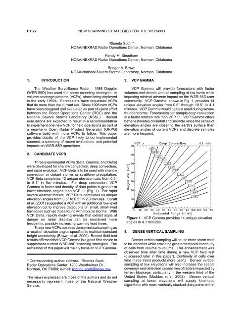
P1.22 NEW SCANNING STRATEGIES FOR THE <strong>WSR</strong>-<strong>88D</strong>Rhonda Scott *NOAA/<strong>NEXRAD</strong> <strong>Radar</strong> Operations Center, Norman, OklahomaRandy M. SteadhamNOAA/<strong>NEXRAD</strong> <strong>Radar</strong> Operations Center, Norman, OklahomaRodger A. BrownNOAA/National Severe Storms Laboratory, Norman, Oklahoma1. INTRODUCTIONThe Wea<strong>the</strong>r Surveillance <strong>Radar</strong> - 1988 Doppler(<strong>WSR</strong>-<strong>88D</strong>) has used <strong>the</strong> same scanning strategies, orvolume coverage patterns (VCPs), since being deployedin <strong>the</strong> early 1990s. Forecasters have requested VCPsthat do more than <strong>the</strong> current set. Since 1998 new VCPshave been designed and evaluated as part of a joint ef<strong>for</strong>tbetween <strong>the</strong> <strong>Radar</strong> Operations Center (ROC) and <strong>the</strong>National Severe Storms Laboratory (NSSL). Recentevaluations are expected to result in a recommendationto implement one new VCP <strong>for</strong> field operations as part ofa near-term Open <strong>Radar</strong> Product Generator (ORPG)software build with more VCPs to follow. This paperprovides details of <strong>the</strong> VCP likely to be implementedsoonest, a summary of recent evaluations, and potentialimpacts on <strong>WSR</strong>-<strong>88D</strong> operations.3. VCP GAMMAVCP Gamma will provide <strong>for</strong>ecasters with fastervolumes and denser vertical sampling at low levels whileimposing minimal adverse impact on <strong>the</strong> <strong>WSR</strong>-<strong>88D</strong> usercommunity. VCP Gamma, shown in Fig. 1, provides 14unique elevation angles from 0.5 " through 19.5 " in 4.1minutes. VCP Gamma would be best used during severethunderstorms. Forecasters can sample deep convectionat a faster rotation rate than VCP 11. VCP Gamma offersbetter estimates of rainfall and snowfall since <strong>the</strong> series ofelevation angles are closer to <strong>the</strong> earth’s surface thanelevation angles of current VCPs and discrete samplesare more frequent.2. CANDIDATE VCPSThree experimental VCPs (Beta, Gamma, and Delta)were developed <strong>for</strong> shallow convection, deep convection,and rapid evolution. VCP Beta is to be used with shallowconvection or distant storms or strati<strong>for</strong>m precipitation.VCP Beta completes 12 unique elevation cuts from 0.5 "to 8.1 " in five minutes. For deep convection, VCPGamma is faster and density of data points is greater atlower elevation angles than VCP 11 (Fig. 1). For rapidsevere wea<strong>the</strong>r threats, VCP Delta completes six uniqueelevation angles from 0.5 " to 6.5 " in 2.3 minutes. Sprattet al. (2001) suggested a VCP with an additional low-levelelevation cut to improve detections of small, short-livedtornadoes such as those found with tropical storms. WithVCP Delta, rapidly evolving events that exhibit signs ofdanger on radar displays can be monitored morefrequently, possibly increasing warning lead times.These new VCPs possess dense vertical sampling asa result of elevation angles specified to maintain constan<strong>the</strong>ight uncertainty (Brown et al. 2000). Recent field testresults affirmed that VCP Gamma is a good first choice tosupplement current <strong>WSR</strong>-<strong>88D</strong> scanning strategies. Theremainder of this paper will mainly focus on VCP Gamma.* Corresponding author address: Rhonda Scott,<strong>Radar</strong> Operations Center, 1200 Wes<strong>the</strong>imer Dr.,Norman, OK 73069; e-mail: rhonda.scott@noaa.govThe views expressed are those of <strong>the</strong> authors and do notnecessarily represent those of <strong>the</strong> National Wea<strong>the</strong>rService.Figure 1 - VCP Gamma provides 14 unique elevationangles in 4.1 minutes.4. DENSE VERTICAL SAMPLINGDenser vertical sampling will cause more storm cellsto be identified while providing greater temporal continuityof cells from volume to volume. This enhancement wasobserved time after time during a new VCP field test(discussed later in this paper). Continuity of cells overtime made trend products more useful. Denser verticalsampling at low elevations will also increase <strong>the</strong> spatialcoverage and detection capabilities of radars impacted byterrain blockage, particularly in <strong>the</strong> western third of <strong>the</strong>United States (Maddox et al. 2002). Denser verticalsampling at lower elevations will supply kinematicalgorithms with more vertically stacked data points within
Figure 2 - Comparisons of <strong>the</strong> vertical resolution beam center between VCP 11 and VCP Gamma at ranges of 50 and250 kilometers. VCP Gamma collects denser data at low-levels as compared to VCP 11.a unit of space. Target features, as recognized by someof <strong>the</strong> meteorological algorithms, will be more likelydetected if <strong>the</strong> vertical gaps between data points arereduced, as depicted in Fig. 2. At a range of 250 km from<strong>the</strong> radar <strong>the</strong>re are six vertically stacked data points below20 km (65,000 feet) from new VCPs. VCP 11 has onlyfour data points at <strong>the</strong> same vertical extent and range.5. RECENT FINDINGSOver 8900 volumes of Level II data from new VCPswere collected from April through June, 2002, as part ofa field test. The <strong>WSR</strong>-<strong>88D</strong> at Keesler AFB, Biloxi, MS(KBIX), was configured with software that allowed testobservers to use six experimental VCPs and <strong>the</strong> fourcurrent VCPs (11, 21, 31, and 32) in real-timemeteorological situations. Based upon <strong>the</strong> characteristicsof new VCPs used <strong>for</strong> specific meteorological situations(Steadham et al. 2002), instructions <strong>for</strong> selecting newVCPs were provided to field test observers located at <strong>the</strong>control center in Norman, OK. Forecasters fromsurrounding NWS offices, Jackson, MS (KJAN), Mobile,AL (KMOB), and Slidell, LA (KLIX), operated <strong>the</strong>irrespective <strong>WSR</strong>-<strong>88D</strong>s with current VCPs in a normalmode. Level II data from <strong>the</strong> four radars were collected<strong>for</strong> post-test analysis. Storms equidistant from KBIX andone or more of surrounding <strong>WSR</strong>-<strong>88D</strong>s will be analyzedto compare algorithm outputs.During <strong>the</strong> field test, observers frequently found morestorm cells identified after switching from VCP 11 or 21 toany of <strong>the</strong> new precipitation mode VCPs. The lifetime ofstorm cells was observed to be longer with new VCPs.That is, once a storm was labeled by <strong>the</strong> system,observers noted <strong>the</strong> storm would maintain its identitymore consistently than one identified with current VCPs.As a result, cell trend products had long durations oftrended values. More past positions of storm tracks wereavailable with new VCPs making storm motion morereliable.While replaying data from fast VCPs it was noted that<strong>the</strong> morphology of storms in a time lapse mode exhibitedgreater detail than from current VCPs. Of <strong>the</strong> problemsencountered, we found after switching to a fast VCP that<strong>the</strong> Routine Products Set (RPS) list would need to bemanually trimmed of product requests since narrowbandloadshedding would begin on <strong>the</strong> 14.4K bps line.Bandwidth measurements of compressed Level IIdata were taken during <strong>the</strong> test <strong>for</strong> each experimentalVCP to quantify communication line rate sufficiency.NSSL scientists have made preliminary comparisons ofalgorithm outputs by replaying archived current and newVCP radar data from <strong>the</strong> field test.A preliminary study of a few individual storms showslonger lead times <strong>for</strong> detecting maximum reflectivity andmesocyclone strength. VCP comparisons will include celland mesocyclone tracking variation. Vertically IntegratedLiquid (VIL) simulations were per<strong>for</strong>med <strong>for</strong> new andcurrent VCPs with several storm profiles (Wood et al.2002). Actual cell-based VIL comparisons will be used toverify <strong>the</strong> <strong>the</strong>oretical results.
6. IMPACTS TO <strong>WSR</strong>-<strong>88D</strong> OPERATIONSOperational <strong>for</strong>ecasters and radar researchers haveenvisioned and suggested improvements in <strong>the</strong> way <strong>the</strong><strong>WSR</strong>-<strong>88D</strong> scans <strong>the</strong> atmosphere. Tradeoffs in dataquality and/or total volume coverage become a designissue. <strong>New</strong> VCPs were designed to optimize knowntradeoffs while satisfying operational needs.With new VCPs, Doppler radars will become capableof faster volumes and increased lower-altitude sampling,thus increasing target resolution. Increased temporal andspatial resolutions will facilitate better warnings and<strong>for</strong>ecasts. Forecasters will see improved hydrologicalradar estimates (Seo et al. 2000), more refined stormstructures, and, potentially, more consistent algorithmper<strong>for</strong>mances. Products will exhibit less artificial variationin radar derived quantities due to beam geometry. Forexample, elevation angles <strong>for</strong> new VCPs were chosen tomake target height uncertainty constant with range(Brown et al. 2000), a particularly effective samplingstrategy <strong>for</strong> viewing mid- and far-range storms.<strong>New</strong> VCPs will affect o<strong>the</strong>r parts of <strong>the</strong> system andsome parts must be changed. The PrecipitationProcessing Subsystem (PPS) algorithm was hard codedto process nothing more rapid than 5 minute volumes. Animproved precipitation algorithm will accompanydeployment of <strong>the</strong> first new VCP to compensate. Morecomputer processing will be required since <strong>the</strong>re will bemore storm cells identified at greater range. Processingmore storms is not a constraint to <strong>the</strong> system since <strong>the</strong>recent deployment of <strong>the</strong> ORPG. The field test bandwidthmeasurements indicated that current communication lineswere sufficient <strong>for</strong> VCP Gamma. From an administrativeperspective, baseline software, testing, and configurationmanagement will be more complex due to more varietiesof Level II data.<strong>New</strong> VCPs were designed <strong>for</strong> specific meteorologicalapplications. Judicious use of a particular VCP at aparticular time will minimize <strong>the</strong> increased wear and tearon <strong>the</strong> radar caused by faster antenna rotation.Forecasters will need to consider several factors when<strong>the</strong>y select from a larger number of VCPs.7. SUMMARY<strong>New</strong> VCPs, when compared to current VCPs, willprovide greater temporal and vertical resolution,particularly at low altitudes. Increased resolution in timeand space should result in improved algorithmper<strong>for</strong>mance capabilities leading to improved warningsand <strong>for</strong>ecasts. Faster VCPs will provide <strong>for</strong>ecasters agreater opportunity to see first signs of potentially severewea<strong>the</strong>r from quickly evolving phenomena. Moreaccurate radar-based precipitation estimates areanticipated. <strong>Radar</strong> data processing systems will need tobe ready <strong>for</strong> <strong>WSR</strong>-<strong>88D</strong> data changes resulting from newVCPs. <strong>New</strong> scanning strategies promise to becomeeffective operational tools <strong>for</strong> <strong>for</strong>ecasters with <strong>the</strong> propertraining and application. The proposed date <strong>for</strong> new VCPfielding is Fall 2003.8. REFERENCESBrown, R. A.., V. T. Wood, and D. Sirmans, 2000:Improved <strong>WSR</strong>-<strong>88D</strong> scanning strategies <strong>for</strong>convective storms. Wea. Forecasting, 15, 208-220.Maddox, R. A., J. Zhang, J. J. Gourley, and K. W.Howard, 2002: Wea<strong>the</strong>r radar coverage over <strong>the</strong>contiguous United States. Wea. Forecasting, 17,927-934.Seo, D. J., J. Breidenbach, R. Fulton, D. Miller, and T.O’Bannon, 2000: Real-time adjustment ofrange-dependent biases in <strong>WSR</strong>-<strong>88D</strong> rainfallestimates due to nonuni<strong>for</strong>m vertical profile ofreflectivity. J. Hydrometeor, 1, 222-240.Spratt, S. M., D. W. Sharp, P. Welsh, A. Sandrik, F.Alsheimer, C. Paxton, Charlie, 1997: A <strong>WSR</strong>-<strong>88D</strong>assessment of tropical cyclone outer rainbandtornadoes. Wea. Forecasting, 12, 479-501.Steadham, R. M., R. A. Brown, and V. T. Wood, 2002:Prospects <strong>for</strong> faster and denser <strong>WSR</strong>-<strong>88D</strong> scanningstrategies. Preprints, 18th International Conferenceon Interactive In<strong>for</strong>mation and Processing, Orlando,Florida, Amer. Meteor. Soc., J89-J91.Wood, V. T., R. A. Brown, and D. R. Cheresnick, 2002:On <strong>the</strong> investigation of Vertically Integrated Liquid(VIL) using <strong>WSR</strong>-<strong>88D</strong>’s new volume coveragepatterns. Preprints, 21 st Conf. On Severe LocalStorms, San Antonio, Texas, Amer. Meteor. Soc.,182-185.