CLARENDON STREET - Derry City Council
CLARENDON STREET - Derry City Council
CLARENDON STREET - Derry City Council
- No tags were found...

You also want an ePaper? Increase the reach of your titles
YUMPU automatically turns print PDFs into web optimized ePapers that Google loves.
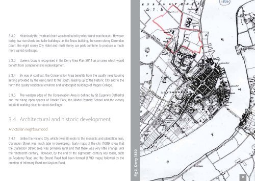
3.3.2 Historically the riverbank front was dominated by wharfs and warehouses. Howevertoday, low rise sheds and taller buildings i.e. the Tesco building, the seven storey ClarendonCourt, the eight storey <strong>City</strong> Hotel and multi storey car park combine to produce a muchmore varied roofscape.3.3.3 Queens Quay is recognised in the <strong>Derry</strong> Area Plan 2011 as an area which wouldbenefit from comprehensive redevelopment.3.3.4 By way of contrast, the Conservation Area benefits from the quality neighbouringsetting provided by the rising land to the south, leading up to the Historic <strong>City</strong> and to thenorth the quality residential environs and landscaped buildings of Magee College.3.3.5 The western edge of the Conservation Area is defined by St Eugene’s Cathedraland the rising open spaces of Brooke Park, the Model Primary School and the closelyinterknit working class terraced dwellings.3.4 Architectural and historic developmentA Victorian neighbourhood3.4.1 Unlike the Historic <strong>City</strong>, which owes its roots to the monastic and plantation eras,Clarendon Street was much later in developing. Early maps of the city (1689) show thatthe Clarendon Street area was primarily rural and that there was very little change untilthe nineteenth century. However, by the end of the eighteenth century key roads, suchas Academy Road and the Strand Road had been formed (1799 maps) followed by thecreation of Infirmary Road and Asylum Road.Fig 2. <strong>Derry</strong> 183015