CLARENDON STREET - Derry City Council
CLARENDON STREET - Derry City Council
CLARENDON STREET - Derry City Council
- No tags were found...

Create successful ePaper yourself
Turn your PDF publications into a flip-book with our unique Google optimized e-Paper software.
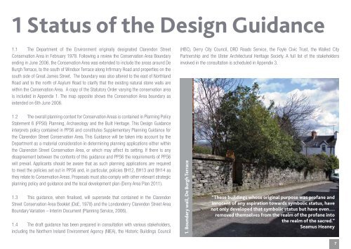
1 Status of the Design Guidance1.1 The Department of the Environment originally designated Clarendon StreetConservation Area in February 1978. Following a review the Conservation Area Boundaryending in June 2006, the Conservation Area was extended to include the areas around DeBurgh Terrace, to the south of Windsor Terrace along Infirmary Road and properties on thesouth side of Great James Street. The boundary was also altered to the east of NorthlandRoad and to the north of Asylum Road to clarify that the existing natural stone walls arewithin the Conservation Area. A copy of the Statutory Order varying the conservation areais included in Appendix 1. The map opposite shows the Conservation Area boundary asextended on 6th June 2006.(HBC), <strong>Derry</strong> <strong>City</strong> <strong>Council</strong>, DRD Roads Service, the Foyle Civic Trust, the Walled <strong>City</strong>Partnership and the Ulster Architectural Heritage Society. A full list of the stakeholdersinvolved in the consultation is scheduled in Appendix 3.1.2 The overall planning context for Conservation Areas is contained in Planning PolicyStatement 6 (PPS6) Planning, Archaeology and the Built Heritage. This Design Guidanceinterprets policy contained in PPS6 and constitutes Supplementary Planning Guidance forthe Clarendon Street Conservation Area. This Guidance will be taken into account by theDepartment as a material consideration in determining planning applications either withinthe Clarendon Street Conservation Area, or which may affect its setting. If there is anydisagreement between the contents of this guidance and PPS6 the requirements of PPS6will prevail. Applicants should be aware that as such planning applications are requiredto meet the policies set out in PPS6 and, in particular, policies BH12, BH13 and BH14 asthey relate to Conservation Areas. Proposals must also comply with other relevant strategicplanning policy and guidance and the local development plan (<strong>Derry</strong> Area Plan 2011).1.3 This guidance, when finalised, will supersede that contained in the ClarendonStreet Conservation Area Booklet (DoE, 1978) and the Londonderry Clarendon Street AreaBoundary Variation – Interim Document (Planning Service, 2006).1.4 The draft guidance has been prepared in consultation with various stakeholders,including the Northern Ireland Environment Agency (NIEA), the Historic Buildings <strong>Council</strong>1. Boundary wall, De Burgh Terrace“These buildings whose original purpose was profane andinnocent of any aspiration towards symbolic status, havenot only developed that symbolic status but have even….removed themselves from the realm of the profane intothe realm of the sacred.”Seamus Heaney7