Air Masses PowerPoint
Air Masses PowerPoint
Air Masses PowerPoint
- No tags were found...

You also want an ePaper? Increase the reach of your titles
YUMPU automatically turns print PDFs into web optimized ePapers that Google loves.
<strong>Air</strong> <strong>Masses</strong>Dr. R. B. Schultz
<strong>Air</strong> <strong>Masses</strong>• In the middle latitudes, most weather patterns are theresult of the movements of large bodies of air, called airmasses.• An air mass is a large body of air, usually 1600kilometers or more across and perhaps severalkilometers thick, which is characterized by homogeneousphysical properties (in particular, temperature andmoisture content) at any given altitude.• A region under the influence of an air mass will probablyexperience generally constant weather conditions, asituation referred to as air mass weather.
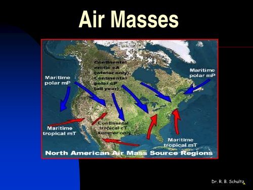
<strong>Air</strong> Mass Source Regions• Areas in which air masses originate are called air masssource regions.• An ideal source region must meet two criteria:• First, it must be an extensive and physically uniform area.• The second criterion is that the area is characterized by ageneral stagnation of atmospheric circulation so that air willstay over the region long enough to come to some measureof equilibrium with the surface.• The classification of an air mass depends on:• (1) the latitude of the source region, and• (2) the nature of the surface in the area of origin—ocean orcontinent.
Abbreviations for <strong>Air</strong> Mass Source Regions• <strong>Air</strong> masses are identified by two-letter codes.• With reference to latitude (temperature), air masses areplaced into one of three categories:• polar (P),• arctic (A), and• tropical (T).• A lowercase letter (m, for maritime, or c for continental)is placed in front of the uppercase letter to designate thenature of the surfaces and the humidity characteristics ofthe air mass.• Using this classification, the following air masses areidentified:• cA, cP, cT, mT, and mP.• Note that there is not a mA source region.
<strong>Air</strong> Mass Modifications• Once an air mass moves from its source region, itnot only modifies the weather of the area it istraveling over, but it is also gradually modified bythe surface over which it is moving.• Modifications can result from:• temperature differences between an air mass andthe surface,• vertical movements induced by cyclones andanticyclones, or• topography.
cP and cA <strong>Air</strong> <strong>Masses</strong>• The day-to-day weather we experience depends onthe temperature, stability, and moisture content ofthe air mass we are experiencing.• Continental polar (cP) and continental arctic(cA) air masses are, as their classification implies,cold and dry.• Although cP air masses are not, as a rule,associated with heavy precipitation, those thatcross the Great Lakes during late autumn andwinter sometimes bring lake-effect snows to theleeward shores.
Lake Effect Snow Belts
Formation of Lake Effect Snows
mP <strong>Air</strong> <strong>Masses</strong>• Maritime polar air masses (mP) form over oceansat high latitudes and are cool to cold and humid.• The weather associated with an invasion of mP airfrom the Atlantic into an area east of theAppalachians and north of Cape Hatteras isknown as a nor'easter.
mT <strong>Air</strong> <strong>Masses</strong>• Maritime tropical (mT) air masses affecting North America mostoften originate over the warm waters of the Gulf of Mexico, theCaribbean Sea, or the adjacent western Atlantic Ocean.• As expected, mT air masses are warm to hot and they are humid.• During winter, when cP air dominates the central and easternUnited States, mT air only occasionally enters this part of thecountry.• However, during the summer, mT air masses from the Gulf,Caribbean, and adjacent Atlantic cover a much wider area of thecontinent and are present for a greater period.• The mT air masses from the Gulf-Caribbean-Atlantic sourceregion are also the source of much (if not most) of theprecipitation received in the eastern two-thirds of the UnitedStates.
<strong>Air</strong> <strong>Masses</strong> and Rainfall• Isohyets, lines drawn on a map that connect placeshaving equal rainfall, illustrate the greatest rainfall inthe Gulf region and a decrease in precipitation withincreasing distance from the mT source region.• Hot and dry continental tropical (cT) air isproduced only in the summer in northern interiorMexico and adjacent parts of the arid southwesternUnited States.
Key Terminology<strong>Air</strong> massLake effect snowIsohyets<strong>Air</strong> mass source regionNor’easter<strong>Air</strong> Mass Source Region Types:cA, cP, cT, mT, and mP