Cartographic design and the quality of climate change maps
Cartographic design and the quality of climate change maps
Cartographic design and the quality of climate change maps

You also want an ePaper? Increase the reach of your titles
YUMPU automatically turns print PDFs into web optimized ePapers that Google loves.
224 Climatic Change (2009) 95:219–230<br />
appropriate color schemes is determined by whe<strong>the</strong>r <strong>the</strong> attributes are qualitative<br />
(use different colors to symbolize different ecotypes) or quantitative (use <strong>the</strong> same<br />
color with variation from light to dark to symbolize <strong>change</strong>s in temperature over<br />
time). <strong>Cartographic</strong> principles guide decisions about how to group (‘classify’) data<br />
for representation. For example, a map showing temperature ranges may have<br />
temperature data assigned to groups using equal intervals (same data range for<br />
each class) or quantiles (same number <strong>of</strong> data points in each class). <strong>Cartographic</strong><br />
principles guide decisions about how to arrange all <strong>the</strong> graphic symbols included on<br />
a map so that <strong>the</strong>re is clarity in <strong>the</strong> overall <strong>design</strong> <strong>and</strong> layout. Numerous texts review<br />
<strong>and</strong> explain cartographic principles (see, for example, Slocum et al. 2005; Kimerling<br />
et al. 2001; Dent1999; Robinson et al. 1995; MacEachren1994; Monmonier 1993).<br />
There is strong consensus within <strong>the</strong> cartographic community about basic principles.<br />
Contemporary map <strong>design</strong> also dem<strong>and</strong>s underst<strong>and</strong>ing <strong>the</strong> constraints <strong>and</strong> opportunities<br />
determined by <strong>the</strong> media on which a map will be reproduced. For<br />
example, <strong>maps</strong> <strong>design</strong>ed for digital display are limited by screen resolution compared<br />
with <strong>maps</strong> <strong>design</strong>ed for printing on paper, <strong>and</strong> ‘endless zoom’ options carry with <strong>the</strong>m<br />
unique problems <strong>of</strong> data accuracy <strong>and</strong> cartographic <strong>design</strong> (see Lobben <strong>and</strong> Patton<br />
2003, for a comparison <strong>of</strong> <strong>design</strong> issues for digital <strong>and</strong> printed <strong>maps</strong>).<br />
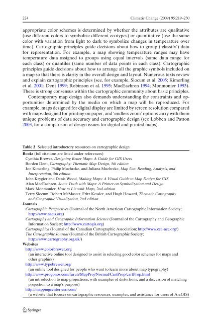
Table 2 Selected introductory resources on cartographic <strong>design</strong><br />
Books (full citations are listed under references)<br />
Cynthia Brewer, Designing Better Maps: A Guide for GIS Users<br />
Borden Dent, Cartography: Thematic Map Design, 5th edition<br />
Jon Kimerling, Philip Muehrcke, <strong>and</strong> Juliana Muehrcke, Map Use: Reading, Analysis, <strong>and</strong><br />
Interpretation, 5th edition<br />
John Krygier <strong>and</strong> Denis Wood, Making Maps: A Visual Guide to Map Design for GIS<br />
Alan MacEachren, Some Truth with Maps: A Primer on Symbolization <strong>and</strong> Design<br />
Mark Monmonier, How to Lie with Maps, 2nd edition<br />
Terry Slocum, Robert McMaster, Fritz Kessler, <strong>and</strong> Hugh Howard, Thematic Cartography<br />
<strong>and</strong> Geographic Visualization, 2nd edition<br />
Journals<br />
<strong>Cartographic</strong> Perspectives (Journal <strong>of</strong> <strong>the</strong> North American <strong>Cartographic</strong> Information Society;<br />
http://www.nacis.org)<br />
Cartography <strong>and</strong> Geographic Information Science (Journal <strong>of</strong> <strong>the</strong> Cartography <strong>and</strong> Geographic<br />
Information Society; http://www.cartogis.org)<br />
<strong>Cartographic</strong>a (Journal <strong>of</strong> <strong>the</strong> Canadian <strong>Cartographic</strong> Association; http://www.cca-acc.org/)<br />
The <strong>Cartographic</strong> Journal (Journal <strong>of</strong> <strong>the</strong> British <strong>Cartographic</strong> Society;<br />
http://www.cartography.org.uk/)<br />
Websites<br />
http://www.colorbrewer.org<br />
(an interactive online tool <strong>design</strong>ed to assist in selecting good color schemes for <strong>maps</strong> <strong>and</strong><br />
o<strong>the</strong>r graphics)<br />
http://www.typebrewer.org/<br />
(an online tool <strong>design</strong>ed for people who want to learn more about map typography)<br />
http://www.progonos.com/furuti/MapProj/Normal/CartProp/cartProp.html<br />
(an introduction to map projections, with examples <strong>of</strong> distortions, <strong>and</strong> a discussion <strong>of</strong> matching<br />
projection to a map’s purpose)<br />
http://mappingcenter.esri.com/<br />
(a website that focuses on cartographic resources, examples, <strong>and</strong> assistance for users <strong>of</strong> ArcGIS)