- Page 1 and 2: State of IllinoisRod. R. Blagojevic
- Page 3: Deglacial History and Paleoenvironm
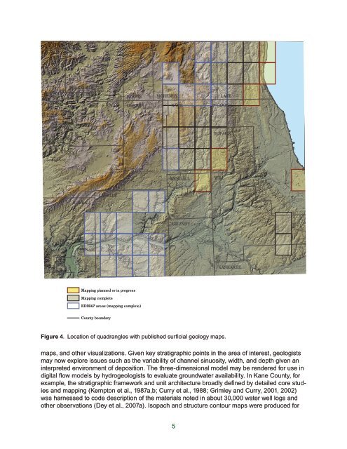
- Page 6 and 7: AcknowledgementsBrandon is grateful
- Page 8 and 9: WINNEBAGOOGLEMarengo MoraineWoodsto
- Page 12 and 13: Surficial fine-textured layerTiskil
- Page 14 and 15: samples, especially diamict units.
- Page 16 and 17: OaOgSuWINNEBAGOOgBOONE MCHENRY LAKE
- Page 18 and 19: Bedrock valley floor changes in Kan
- Page 20 and 21: illite peak (8.8°2) with thecompou
- Page 22 and 23: Grayslake Peat (gr)Peoria Silt (not
- Page 24 and 25: DEPOSITS OF THE LAST GLACIATIONMaso
- Page 26 and 27: WisconsinCheck here ifH homestead c
- Page 28 and 29: Table 1 Summary of particle size of
- Page 30 and 31: Table 2 Selected physical propertie
- Page 32 and 33: l-h0 counts per second50Diamicton,b
- Page 34 and 35: Geochronologicand Chronostratigraph
- Page 36 and 37: Wisconsin EpisodeAthens Subepisode
- Page 38 and 39: MarengoPhaseMarengo MoraineHarvardS
- Page 40: Three erosional channels cut across
- Page 43 and 44: Boring WAD-05-02Tinley Moraine*DesP
- Page 45 and 46: Figure 30 Glacial and lake phases a
- Page 47 and 48: were not intended to overlap (North
- Page 49: West Chicago Moraine,9c Higgins/Sut
- Page 52 and 53: Benn D.I., 2002, Clast fabric devel
- Page 54 and 55: Curry, B.B. 2003. Linking Ostracode
- Page 56 and 57: Eyles, N. 1983. Glacial Geology: An
- Page 58 and 59: Hajic, E.R., 1990. Late Pleistocene
- Page 60 and 61:
Johnson, W. H., A. K. Hansel, E. A.
- Page 62 and 63:
Leighton, M.M., P. MacClintock, L.E
- Page 64 and 65:
Piskin, K., and R. E. Bergstrom, 19
- Page 66 and 67:
Vagt, P. J., 1987. Characterization
- Page 68 and 69:
STOP 1: Buffalo Rock State ParkLarg
- Page 70 and 71:
ner channel began. Previously, thes
- Page 72 and 73:
Figure 3 (A) Example of outer erosi
- Page 74 and 75:
Stop 2a: Wedron Silica Company Quar
- Page 76 and 77:
N N N0.0W20.5W1W3Depth (m)1.01.5Rin
- Page 78 and 79:
0.00.2W3W2W1W1W3W2Ringshearresult0.
- Page 80 and 81:
to the arrival of the last glaciers
- Page 82 and 83:
Sedimentology and stratigraphyThe c
- Page 84 and 85:
prairie-like. Pollen analyses may b
- Page 86 and 87:
CarboniferousFigure 1 Carboniferous
- Page 88 and 89:
Figure 3 Largest and best preserved
- Page 90 and 91:
Figure 6 Small normal faults in lam
- Page 92 and 93:
and mineralogy, we propose that the
- Page 94 and 95:
Stop 4: Oswego ChannelThe 15,770 C-
- Page 96 and 97:
NewarkMarseillesIroquoisSt. AnneOsw
- Page 98 and 99:
Joliet sublobe;retreat to theValpar
- Page 100 and 101:
Sediment coresSeveral sediment core
- Page 102 and 103:
formed during the late Livingston P
- Page 104 and 105:
are being examined by Professor L.
- Page 106 and 107:
assistant secretary of the Smithson
- Page 108 and 109:
Annotated Illustrated Guide to the
- Page 110 and 111:
Figure 4 The BrewsterCreek mastodon
- Page 112 and 113:
Figure 6 The left lower 3rd molar o
- Page 114 and 115:
Figure 8 The left upper 3rd molar o
- Page 116 and 117:
Figure 10 This slide elaborates on
- Page 118 and 119:
Aurora Mastodont Project 2004 - A s
- Page 120 and 121:
a full skeleton still buried. Ed Mo
- Page 122 and 123:
Figure 17 Field leader Anita Weber
- Page 124 and 125:
Figure 18 Paleontologist For A Day
- Page 126 and 127:
paleontologist/geologist/archeologi
- Page 128 and 129:
scientific rationale behind the see
- Page 130 and 131:
tures exposed, from well drained in
- Page 132 and 133:
N1 km1 miAA’lbgphhwheA1380 lbFelt
- Page 134 and 135:
Table 1 Soil horizonation and depth
- Page 136 and 137:
Figure 5 Morphological measure of t
- Page 138 and 139:
vial upper solum characteristics, d
- Page 140 and 141:
material indicates long term disper
- Page 142 and 143:
(Table 1). Sand and silt values oft
- Page 144 and 145:
STOP 7: DeKalb moundsArchives of de
- Page 146 and 147:
acA A ‘*"e H-2278bde(x)1 kmFigure
- Page 148 and 149:
1 kmFigure 4 Typical distribution a
- Page 150 and 151:
Vertical exaggeration =20x5 mB-9AWe
- Page 152 and 153:
Valve concentration(#/gm, moist)0.0
- Page 154 and 155:
200-8Value (‰)-6 -4 -2 0 2 0.00 0
- Page 156 and 157:
sions encompass the period of final
- Page 158 and 159:
Stop 8: Spring Lake Sand and Gravel
- Page 160 and 161:
Stratigraphy and Mechanical Stratig
- Page 162 and 163:
ABCDEFFigure 3 Characteristic defor
- Page 164 and 165:
a.b.C90 mC'WED85 mD'c.D200 mD'NSd.D
- Page 166 and 167:
a.b.c.d. e.LHudSTATION E1 E2 E3LHld
- Page 168 and 169:
In the weaker units, several charac
- Page 170 and 171:
Stop 9: Thelen Sand and Gravel Pits
- Page 172 and 173:
Table 1 Lithofacies code for fluvia
- Page 174 and 175:
The erosion of the large semi-circu
- Page 176 and 177:
Topset sequences are composed of bo
- Page 178 and 179:
APPENDIX A. Description of Profile
- Page 180 and 181:
pinches out laterally.4 879.6 10.5