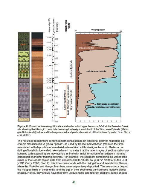
Age (cal yr BP)AMS 14 C datesDepth (cm)DiachronicUnitsWeight percent0 10010,500250peat11,00011,50012,000300350organic matter12,500400marl13,00013,50014,00014,500450500550600Hudson Episodecalcium carbonatesilt loam,laminated15,00015,50016,000650700750800850Keller Farm PhaseLake Michigan SubepisodeWisconsin Episodeterriginous sediment(quartz, feldspar, clay minerals)900Figure 31 Downcore loss-on-ignition data <strong>and</strong> radiocarbon ages from core BC-1 at the Brewster Creeksite showing the lithologic contact demarcating the terriginous-rich silt <strong>of</strong> the Wisconsin Episode (MichiganSubepisode) below <strong>and</strong> the biogenic marl <strong>and</strong> peat-rich material <strong>of</strong> the Hudson Episode. From Curryet al. (2007).The results <strong>of</strong> recent work in northeastern <strong>Illinois</strong> poses an additional dilemna regarding diachronicclassification. A glacial “phase”, as used by Hansel <strong>and</strong> Johnson (1996) is the timeassociated with deposition <strong>of</strong> a material referent (i.e., a lithostratigraphic unit). Radiocarbondating <strong>of</strong> fossils in ice-walled lake sediment indicates that the latter stages <strong>of</strong> sedimentation associatedwith stagnating ice may overlap in time with initial formation <strong>of</strong> an adjacent morainecomposed <strong>of</strong> another material referent. For example, the sediment comprising ice-walled lakeplains <strong>of</strong> the DeKalb region date from about 20,400 to 18,600 cal yr BP (17,250 to 15,150 C-14yr BP; Curry, 2008; Stop 7); this time corresponds with the Livingston <strong>and</strong> Woodstock Phaseswhen the Yorkville <strong>and</strong> Haeger Members were respectively deposited. The lakes occur beyondthe mapped limits <strong>of</strong> these units, <strong>and</strong> the age <strong>of</strong> their sediments transgresses multiple glacialphases. Hence, they should have their own unique name <strong>and</strong> referent sections. Since phases40
were not intended to overlap (North American Commission <strong>of</strong> Stratigraphic Nomenclature, 1983;Hansel <strong>and</strong> Johnson, 1996), a special case is necessary for ice-walled lake plain deposits. Toavoid a proliferation <strong>of</strong> new diachronic names, it is proposed that the ice-walled lake deposits in<strong>Illinois</strong> were deposited during the early Keller Farm phase.Hudson Episode (14,670 cal yr BP – present). The Hudson Episode began when loess-relatedsedimentation ceased after the last glaciation. As discussed above, this time boundary atthe Brewster Creek site coincides with a material change from silt loam to sediment that is dominatedby biogenic marl <strong>and</strong> peat. At this site, the lake was relatively shallow (< 7 m deep). Thesediment record from deeper lakes (17-20 m deep) in northeastern <strong>Illinois</strong> (e.g. Crystal Lake inSE McHenry County) are complicated by layers <strong>of</strong> s<strong>and</strong>y sediment probably derived from turbiditesthat delivered littoral sediment to pr<strong>of</strong>undal zones by deep, wind-driven waves during storms(Curry, unpublished data).The deglacial <strong>and</strong> postglacial history <strong>of</strong> northeastern <strong>Illinois</strong> is known from pollen <strong>and</strong> ostracoderecords from cores sampled from Nelson <strong>and</strong> Mastodon lakes (Kane County), Crystal Lake(McHenry County), <strong>and</strong> Brewster Creek (Curry et al., 2007). A synopsis <strong>of</strong> the late Pleistocene<strong>and</strong> Holocene vegetation history begins with replacement <strong>of</strong> tundra vegetation by a dense borealforest at about 16,700 cal yr BP (data from Nelson Lake <strong>and</strong> from Stop 5). This coniferousforest was dense <strong>and</strong> comprised almost exclusively <strong>of</strong> white <strong>and</strong> black spruce, <strong>and</strong> persisted toabout 14,670 cal yr BP. During the transition from the last glacial to present interglacial (14,670cal yr BP to about 10,700 cal yr BP), deciduous trees became more important, especially blackash. The dominance in the pollen record <strong>of</strong> this wetl<strong>and</strong>-loving tree <strong>and</strong> spruce indicates thatnortheastern <strong>Illinois</strong> remained wet during the transition. At Brewster Creek, spruce pollen persistedto about 10,500 cal yr BP, about 650 years longer than at Crystal Lake (Gonzales <strong>and</strong>Grimm, unpublished data). The nature <strong>of</strong> the remainder <strong>of</strong> the Holocene vegetation record hasbeen investigated in Nelson Lake (Nelson et al., 2006) <strong>and</strong> in Crystal Lake to about 8,000 cal yrBP (Gonzales, unpublished data). The early Holocene deciduous forest included abundant oak,elm, <strong>and</strong> black ash, suggesting conditions somewhat wetter than present. Pollen-assemblages<strong>and</strong> the δ13C values <strong>and</strong> accumulation rates <strong>of</strong> charcoal reveal that the prairie initially developedfrom about 9,000 to 7,300 cal yr BP. There was a brief return to wetter conditions from 7,300 toabout 6,200 cal yr BP after which there was full expansion <strong>of</strong> the prairie (Nelson et al., 2006).Tree st<strong>and</strong>s were comprised chiefly <strong>of</strong> oak, hickory, <strong>and</strong> walnut, <strong>and</strong> persisted to when the areawas settled by Europeans in the early-mid 1800’s.The modern l<strong>and</strong>scape largely reflects the glacial legacy presented above although the postglaciall<strong>and</strong>scape has been smoothed somewhat by infilling <strong>of</strong> depressions <strong>and</strong> low areas withalluvium <strong>and</strong> biogenic sediment. Since the encroachment <strong>of</strong> settlers more than 150 years ago innortheastern <strong>Illinois</strong>, many trees have been removed, swampy soils have been drained for agriculturaldevelopment, <strong>and</strong> large amounts <strong>of</strong> s<strong>and</strong> <strong>and</strong> gravel have been extracted for aggregateused in the construction <strong>of</strong> roads <strong>and</strong> foundations. Lakes, both natural <strong>and</strong> man-made, havefilled in quickly with sediment derived from agricultural practices <strong>and</strong> urban improvements. Asthe population <strong>of</strong> northeastern <strong>Illinois</strong> grows, the glacial deposits have found new significanceas both a receptacle for waste disposal <strong>and</strong> as a groundwater resource, in addition to continueduse in agriculture <strong>and</strong> as an aggregate resource.41
- Page 1 and 2: State of IllinoisRod. R. Blagojevic
- Page 3: Deglacial History and Paleoenvironm
- Page 6 and 7: AcknowledgementsBrandon is grateful
- Page 8 and 9: WINNEBAGOOGLEMarengo MoraineWoodsto
- Page 10 and 11: Figure 3 Projected growth areas in
- Page 12 and 13: Surficial fine-textured layerTiskil
- Page 14 and 15: samples, especially diamict units.
- Page 16 and 17: OaOgSuWINNEBAGOOgBOONE MCHENRY LAKE
- Page 18 and 19: Bedrock valley floor changes in Kan
- Page 20 and 21: illite peak (8.8°2) with thecompou
- Page 22 and 23: Grayslake Peat (gr)Peoria Silt (not
- Page 24 and 25: DEPOSITS OF THE LAST GLACIATIONMaso
- Page 26 and 27: WisconsinCheck here ifH homestead c
- Page 28 and 29: Table 1 Summary of particle size of
- Page 30 and 31: Table 2 Selected physical propertie
- Page 32 and 33: l-h0 counts per second50Diamicton,b
- Page 34 and 35: Geochronologicand Chronostratigraph
- Page 36 and 37: Wisconsin EpisodeAthens Subepisode
- Page 38 and 39: MarengoPhaseMarengo MoraineHarvardS
- Page 40: Three erosional channels cut across
- Page 43 and 44: Boring WAD-05-02Tinley Moraine*DesP
- Page 45: Figure 30 Glacial and lake phases a
- Page 49: West Chicago Moraine,9c Higgins/Sut
- Page 52 and 53: Benn D.I., 2002, Clast fabric devel
- Page 54 and 55: Curry, B.B. 2003. Linking Ostracode
- Page 56 and 57: Eyles, N. 1983. Glacial Geology: An
- Page 58 and 59: Hajic, E.R., 1990. Late Pleistocene
- Page 60 and 61: Johnson, W. H., A. K. Hansel, E. A.
- Page 62 and 63: Leighton, M.M., P. MacClintock, L.E
- Page 64 and 65: Piskin, K., and R. E. Bergstrom, 19
- Page 66 and 67: Vagt, P. J., 1987. Characterization
- Page 68 and 69: STOP 1: Buffalo Rock State ParkLarg
- Page 70 and 71: ner channel began. Previously, thes
- Page 72 and 73: Figure 3 (A) Example of outer erosi
- Page 74 and 75: Stop 2a: Wedron Silica Company Quar
- Page 76 and 77: N N N0.0W20.5W1W3Depth (m)1.01.5Rin
- Page 78 and 79: 0.00.2W3W2W1W1W3W2Ringshearresult0.
- Page 80 and 81: to the arrival of the last glaciers
- Page 82 and 83: Sedimentology and stratigraphyThe c
- Page 84 and 85: prairie-like. Pollen analyses may b
- Page 86 and 87: CarboniferousFigure 1 Carboniferous
- Page 88 and 89: Figure 3 Largest and best preserved
- Page 90 and 91: Figure 6 Small normal faults in lam
- Page 92 and 93: and mineralogy, we propose that the
- Page 94 and 95: Stop 4: Oswego ChannelThe 15,770 C-
- Page 96 and 97:
NewarkMarseillesIroquoisSt. AnneOsw
- Page 98 and 99:
Joliet sublobe;retreat to theValpar
- Page 100 and 101:
Sediment coresSeveral sediment core
- Page 102 and 103:
formed during the late Livingston P
- Page 104 and 105:
are being examined by Professor L.
- Page 106 and 107:
assistant secretary of the Smithson
- Page 108 and 109:
Annotated Illustrated Guide to the
- Page 110 and 111:
Figure 4 The BrewsterCreek mastodon
- Page 112 and 113:
Figure 6 The left lower 3rd molar o
- Page 114 and 115:
Figure 8 The left upper 3rd molar o
- Page 116 and 117:
Figure 10 This slide elaborates on
- Page 118 and 119:
Aurora Mastodont Project 2004 - A s
- Page 120 and 121:
a full skeleton still buried. Ed Mo
- Page 122 and 123:
Figure 17 Field leader Anita Weber
- Page 124 and 125:
Figure 18 Paleontologist For A Day
- Page 126 and 127:
paleontologist/geologist/archeologi
- Page 128 and 129:
scientific rationale behind the see
- Page 130 and 131:
tures exposed, from well drained in
- Page 132 and 133:
N1 km1 miAA’lbgphhwheA1380 lbFelt
- Page 134 and 135:
Table 1 Soil horizonation and depth
- Page 136 and 137:
Figure 5 Morphological measure of t
- Page 138 and 139:
vial upper solum characteristics, d
- Page 140 and 141:
material indicates long term disper
- Page 142 and 143:
(Table 1). Sand and silt values oft
- Page 144 and 145:
STOP 7: DeKalb moundsArchives of de
- Page 146 and 147:
acA A ‘*"e H-2278bde(x)1 kmFigure
- Page 148 and 149:
1 kmFigure 4 Typical distribution a
- Page 150 and 151:
Vertical exaggeration =20x5 mB-9AWe
- Page 152 and 153:
Valve concentration(#/gm, moist)0.0
- Page 154 and 155:
200-8Value (‰)-6 -4 -2 0 2 0.00 0
- Page 156 and 157:
sions encompass the period of final
- Page 158 and 159:
Stop 8: Spring Lake Sand and Gravel
- Page 160 and 161:
Stratigraphy and Mechanical Stratig
- Page 162 and 163:
ABCDEFFigure 3 Characteristic defor
- Page 164 and 165:
a.b.C90 mC'WED85 mD'c.D200 mD'NSd.D
- Page 166 and 167:
a.b.c.d. e.LHudSTATION E1 E2 E3LHld
- Page 168 and 169:
In the weaker units, several charac
- Page 170 and 171:
Stop 9: Thelen Sand and Gravel Pits
- Page 172 and 173:
Table 1 Lithofacies code for fluvia
- Page 174 and 175:
The erosion of the large semi-circu
- Page 176 and 177:
Topset sequences are composed of bo
- Page 178 and 179:
APPENDIX A. Description of Profile
- Page 180 and 181:
pinches out laterally.4 879.6 10.5