kayak - Conservation Ontario
kayak - Conservation Ontario
kayak - Conservation Ontario

You also want an ePaper? Increase the reach of your titles
YUMPU automatically turns print PDFs into web optimized ePapers that Google loves.
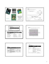
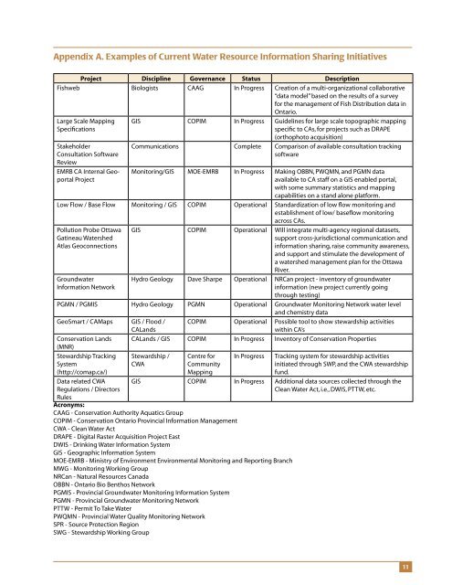
Appendix A. Examples of Current Water Resource Information Sharing InitiativesProject Discipline Governance Status DescriptionFishweb Biologists CAAG In Progress Creation of a multi-organizational collaborative“data model” based on the results of a surveyfor the management of Fish Distribution data in<strong>Ontario</strong>.Large Scale MappingSpecificationsStakeholderConsultation SoftwareReviewEMRB CA Internal GeoportalProjectGIS COPIM In Progress Guidelines for large scale topographic mappingspecific to CAs, for projects such as DRAPE(orthophoto acquisition)Communications Complete Comparison of available consultation trackingsoftwareMonitoring/GIS MOE-EMRB In Progress Making OBBN, PWQMN, and PGMN dataavailable to CA staff on a GIS enabled portal,with some summary statistics and mappingcapabilities on a stand alone platform.Low Flow / Base Flow Monitoring / GIS COPIM Operational Standardization of low flow monitoring andestablishment of low/ baseflow monitoringacross CAs.Pollution Probe OttawaGatineau WatershedAtlas GeoconnectionsGroundwaterInformation NetworkGIS COPIM Operational Will integrate multi-agency regional datasets,support cross-jurisdictional communication andinformation sharing, raise community awareness,and support and stimulate the development ofa watershed management plan for the OttawaRiver.Hydro Geology Dave Sharpe Operational NRCan project - inventory of groundwaterinformation (new project currently goingthrough testing)PGMN / PGMIS Hydro Geology PGMN Operational Groundwater Monitoring Network water leveland chemistry dataGeoSmart / CAMaps GIS / Flood /CALandsCOPIM Operational Possible tool to show stewardship activitieswithin CA’s<strong>Conservation</strong> Lands CALands / GIS COPIM In Progress Inventory of <strong>Conservation</strong> Properties(MNR)Stewardship TrackingSystem(http://comap.ca/)Stewardship /CWACentre forCommunityMappingIn Progress Tracking system for stewardship activitiesinitiated through SWP, and the CWA stewardshipfund.Data related CWARegulations / DirectorsRulesGIS COPIM In Progress Additional data sources collected through theClean Water Act, i.e., DWIS, PTTW, etc.Acronyms:CAAG - <strong>Conservation</strong> Authority Aquatics GroupCOPIM - <strong>Conservation</strong> <strong>Ontario</strong> Provincial Information ManagementCWA - Clean Water ActDRAPE - Digital Raster Acquisition Project EastDWIS - Drinking Water Information SystemGIS - Geographic Information SystemMOE-EMRB - Ministry of Environment Environmental Monitoring and Reporting BranchMWG - Monitoring Working GroupNRCan - Natural Resources CanadaOBBN - <strong>Ontario</strong> Bio Benthos NetworkPGMIS - Provincial Groundwater Monitoring Information SystemPGMN - Provincial Groundwater Monitoring NetworkPTTW - Permit To Take WaterPWQMN - Provincial Water Quality Monitoring NetworkSPR - Source Protection RegionSWG - Stewardship Working Group11