Geographical distribution of Tillandsia lomas in the Atacama ... - IEB
Geographical distribution of Tillandsia lomas in the Atacama ... - IEB
Geographical distribution of Tillandsia lomas in the Atacama ... - IEB

Create successful ePaper yourself
Turn your PDF publications into a flip-book with our unique Google optimized e-Paper software.
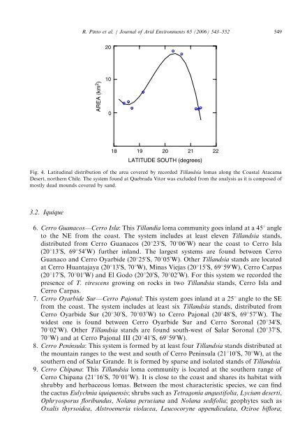
ARTICLE IN PRESSR. P<strong>in</strong>to et al. / Journal <strong>of</strong> Arid Environments 65 (2006) 543–552 54920AREA (km 2 )10018 19 20 21 22LATITUDE SOUTH (degrees)Fig. 4. Latitud<strong>in</strong>al <strong>distribution</strong> <strong>of</strong> <strong>the</strong> area covered by recorded <strong>Tillandsia</strong> <strong>lomas</strong> along <strong>the</strong> Coastal <strong>Atacama</strong>Desert, nor<strong>the</strong>rn Chile. The system found at Quebrada Vitor was excluded from <strong>the</strong> analysis as it is composed <strong>of</strong>mostly dead mounds covered by sand.3.2. Iquique6. Cerro Guanacos—Cerro Isla: This Tillandia loma community goes <strong>in</strong>land at a 451 angleto <strong>the</strong> NE from <strong>the</strong> coast. The system <strong>in</strong>cludes at least eleven <strong>Tillandsia</strong> stands,distributed from Cerro Guanacos (20123 0 S, 70106 0 W) near <strong>the</strong> coast to Cerro Isla(20113 0 S, 69154 0 W) fur<strong>the</strong>r <strong>in</strong>land. The largest systems are found between CerroGuanaco and Cerro Oyarbide (20125 0 S, 70105 0 W). O<strong>the</strong>r <strong>Tillandsia</strong> stands are locatedat Cerro Huantajaya (20113 0 S, 701W), M<strong>in</strong>as Viejas (20115 0 S, 69159 0 W), Cerro Carpas(20117 0 S, 70101 0 W) and El Godo (20120 0 S, 70102 0 W). For this system we recorded <strong>the</strong>presence <strong>of</strong> T. virescens grow<strong>in</strong>g on rocks <strong>in</strong> two <strong>Tillandsia</strong> stands, Cerro Isla andCerro Carpas.7. Cerro Oyarbide Sur—Cerro Pajonal: This system goes <strong>in</strong>land at a 251 angle to <strong>the</strong> SEfrom <strong>the</strong> coast. The system <strong>in</strong>cludes at least six <strong>Tillandsia</strong> stands, distributed fromCerro Oyarbide Sur (20130 0 S, 70103 0 W) to Cerro Pajonal (20148 0 S, 69157 0 W). Thewidest one is found between Cerro Oyarbide Sur and Cerro Soronal (20134 0 S,70102 0 W). O<strong>the</strong>r <strong>Tillandsia</strong> stands are found south-west <strong>of</strong> Salar Soronal (20137 0 S,701W) and at Cerro Pajonal III (20141 0 S, 69159 0 W).8. Cerro Península: This system is formed by at least four <strong>Tillandsia</strong> stands distributed at<strong>the</strong> mounta<strong>in</strong> ranges to <strong>the</strong> west and south <strong>of</strong> Cerro Penı´nsula (21110 0 S, 701W), at <strong>the</strong>sou<strong>the</strong>rn end <strong>of</strong> Salar Grande. It is formed by sparse and isolated stands <strong>of</strong> <strong>Tillandsia</strong>.9. Cerro Chipana: This <strong>Tillandsia</strong> loma community is located at <strong>the</strong> sou<strong>the</strong>rn range <strong>of</strong>Cerro Chipana (21116 0 S, 70101 0 W). It is close to <strong>the</strong> coast and shares its habitat withshrubby and herbaceous <strong>lomas</strong>. Between <strong>the</strong> most characteristic species, we can f<strong>in</strong>d<strong>the</strong> cactus Eulychnia iquiquensis; shrubs such as Tetragonia angustifolia, Lycium deserti,Ophryosporus floribundus, Nolana peruviana and Nolana sedifolia; geophytes such asOxalis thyrsoidea, Alstroemeria violacea, Leucocoryne appendiculata, Oziroe biflora;