Free - Alberta Conservation Association
Free - Alberta Conservation Association
Free - Alberta Conservation Association
- No tags were found...

You also want an ePaper? Increase the reach of your titles
YUMPU automatically turns print PDFs into web optimized ePapers that Google loves.
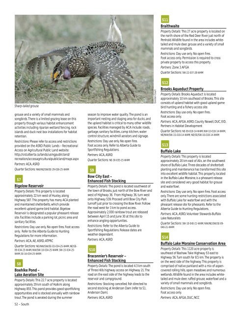
S11BraithwaiteProperty Details: This 27 acre property is located onthe north shore of the Red Deer River just north ofPenhold. Wildlife found in the area includes whitetailedand mule deer, grouse and a variety of smallmammals and songbirds.Restrictions: Day use only. No open fires.Foot access only. Permission is required to crossprivate property to access this property.Partners: Zone 3 AFGAQuarter Sections: SW-22-037-28-W4MSharp-tailed grousegrouse and a variety of small mammals andsongbirds. There is a limited grazing lease on thisproperty though various habitat enhancementactivities including riparian wetland fencing, rockislands and duck nest box installations for habitatretention.Restrictions: Please refer to access and restrictionsprovided on the ASRD Public Lands – RecreationalAccess on Agricultural Public Land website:http://srd.alberta.ca/lands/usingpublicland/recreation/accessagriculturalpublicland/maps.aspxPartners: ACA, ASRDQuarter Sections: NW/NE/SW/SE-29-036-25-W4MS7Bigelow ReservoirProperty Details: This property is locatedapproximately 22 km west of Huxley, alongHighway 587. This property has many ACA plantedand maintained shelterbelts, which provideexcellent upland game bird habitat. BigelowReservoir is designated a popular pheasant releasesite. Facilities include a parking lot, picnic area andsanitary facilities.Restrictions: Day use only. No open fires. Foot accessonly. Refer to the <strong>Alberta</strong> Guide to HuntingRegulations for more information.Partners: ACA, AE, ASRD, ATPRCQuarter Sections: NE/NW/SW/SE-03-034-25-W4M, NE/SE-09-034-25-W4M, NW/SW-10-034-25-W4M, SW-15-034-25-W4M, SE-16-034-25-W4MS8Boehlke Pond –Lake Aeration SiteProperty Details: This 22.7 acre property is locatedapproximately 29 km south of Halkirk alongHighway 855. This pond provides good sportfishingopportunities and is stocked annually with rainbowtrout. The pond is aerated during the summer52 – Southseason to improve water quality. The pond is animportant nesting and staging area for ducks, andthe upland habitat is critical to many other wildlifespecies. Facilities managed by ACA include: roads,garbage, sanitary facilities, camp kitchen, watercontrol structure, windmill aerators and signage.Restrictions: Day use only. No open fires.Foot access only. Refer to <strong>Alberta</strong> Guide toSportfishing Regulations.Partners: ACA, ASRDQuarter Sections: NE-30-035-15-W4MS9Bow City East –Enhanced Fish StockingProperty Details: The pond is located southwest ofthe town of Brooks, just north of the Bow River andwest of Highway 36. From Highway 36, turn westonto Highway 539. Proceed until Bow City Parkturnoff just prior to crossing the Bow River. Followthe road west for 3 km to pond access.Approximately 2,000 rainbow trout are releasedbetween April 15 and June 30 at this site toenhance angling opportunities.Restrictions: Refer to the <strong>Alberta</strong> Guide toSportfishing Regulations. Release dates areweather dependant.Partners: ACA, ASRDS10Braconnier’s Reservoir –Enhanced Fish StockingProperty Details: The pond is located 4.3 km southof Three Hills highway access on Highway 21. Theroad on the east side of the highway leads to thereservoir and campground.Restrictions: Stocking cancelled, fish directed tosecond stocking at Anderson Dam (refer to S1,Anderson Dam).Partners: ACA, ASRDGordon CourtS12Brooks Aqueduct PropertyProperty Details: Brooks Aqueduct is locatedapproximately 10 km southeast of Brooks. This siteconsists of upland habitat with good upland gamebird hunting and a fishery access site.Restrictions: Day use only. No open fires.Foot access only.Partners: ACA, AFGA, ASRD, County Newell, DUC, EID,Partners in Habitat DevelopmentQuarter Sections: NE-09-018-14-W4M, NW-10-018-14-W4M,NE/NW/SW-15-018-14-W4M, NE/SE/SW-16-018-14-W4MS13Buffalo LakeProperty Details: This property is locatedapproximately 20 km east of Alix, on the southwestshore of Buffalo Lake. Three decades of shelterbeltplanting and maintenance has transformed this siteinto excellent wildlife habitat. This property, locatedin the Buffalo Lake Moraine, is a pheasant releasesite and considered very good habitat for grouseand waterfowl.Restrictions: Day use only. No open fires. Foot accessonly. There are some hunting restrictions associatedwith Buffalo Lake for waterfowl and with thepheasant release site for pheasants. Refer to the<strong>Alberta</strong> Guide to Hunting Regulations.Partners: ACA, ASRD, Volunteer Stewards-BuffaloLake NaturalistsQuarter Sections: SW-10-040-21-W4M, NW/NE/SW/SE-09-040-21-W4MS14Buffalo Lake Moraine <strong>Conservation</strong> AreaProperty Details: This 1120 acre property issoutheast of Bashaw. Take Highway 53 east toHighway 56. Turn south for 8.5 km. The property ison the west side of the highway. This property iscomprised of native parkland with a mix of aspencoveredrolling hills, open meadows and numerouswetlands. Wildlife found in the area includes whitetailedand mule deer, ruffed grouse, waterfowl and avariety of small mammals and songbirds.Restrictions: Day use only. No open fires.Foot access only.Partners: ACA, AFGA, DUC, NCC