IMO MPEC 723 - Gard
IMO MPEC 723 - Gard
IMO MPEC 723 - Gard
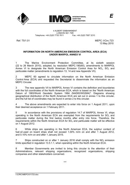
Create successful ePaper yourself
Turn your PDF publications into a flip-book with our unique Google optimized e-Paper software.
E4 ALBERT EMBANKMENTLONDON SE1 7SRTelephone: +44 (0)20 7735 7611 Fax: +44 (0)20 7587 3210Ref. T5/1.01MEPC.1/Circ.<strong>723</strong>13 May 2010INFORMATION ON NORTH AMERICAN EMISSION CONTROL AREA (ECA)UNDER MARPOL ANNEX VI1 The Marine Environment Protection Committee, at its sixtieth session(22 to 26 March 2010), adopted, by resolution MEPC.190(60), amendments to MARPOLAnnex VI to designate the North American Emission Control Area for NO x , SO x andparticulate matter (amendments to regulation 13, 14 and new Appendix VII).2 MEPC 60 agreed to circulate information on the North American EmissionControl Area (ECA) and requested the Secretariat to disseminate the information as anMEPC Circular.3 The new appendix VII to MARPOL Annex VI contains the definition and boundarieswith the full coordinates of the North American ECA, which is based on the "North AmericanDatum of 1983/World Geodetic System 1984 (NAD83/WGS84)". Diagrams showinggeographical distribution of the North American ECA are set out in annex 1 to this circular,and the full list of coordinates may be found in annex 2 to this circular.4 The above amendments are expected to enter into force on 1 August 2011, upontheir deemed acceptance on 1 February 2011.5 In accordance with the provisions of regulation 14.7 of MARPOL Annex VI, shipsoperating in the North American ECA are exempted from the requirements for SO x andparticulate matter during the first twelve months after entry into force. Therefore, therequirements within the North American ECA for SO x and particulate matter will be effectiveon 1 August 2012.6 While ships are operating in the North American ECA, the sulphur content offuel oil used on board ships shall not exceed 1.00% m/m on and after 1 August 2012,and 0.10% m/m on and after 1 January 2015.7 Ships constructed on or after 1 January 2016 shall comply with the NO x emissionlimits specified in regulation 13.5.1.1, when operating within the North American ECA.8 Member Governments are invited to bring this circular to the attention of theirAdministrations, relevant shipping organizations, recognized organizations, shippingcompanies and other stakeholders concerned.***I:\CIRC\MEPC\01\<strong>723</strong>.doc
MEPC.1/Circ.<strong>723</strong>Annex 1, page 1ANNEX 1GEOGRAPHICAL DISTRIBUTION OF THE NORTH AMERICANEMISSION CONTROL AREA1 General view of the North American Emission Control Area2 Magnified view of the Pacific coastNote: The points correspond to the list of coordinates in paragraph 1 of annex 2.I:\CIRC\MEPC\01\<strong>723</strong>.doc
POINT LATITUDE LONGITUDE15515615715815916016116216316416516616716816917017117217317417517617717817918018118218318418518618718818919019119219319419519619719819920020120220320420520624º 08 58 N.24º 08 30 N.24º 08 26 N.24º 07 28 N.24º 02 20 N.23º 59 60 N.23º 55 32 N.23º 53 52 N.23º 50 52 N.23º 50 02 N.23º 49 05 N.23º 49 05 N.23º 49 42 N.23º 51 14 N.23º 51 14 N.23º 49 42 N.23º 49 32 N.23º 49 24 N.23º 49 52 N.23º 51 22 N.23º 52 27 N.23º 54 04 N.23º 55 47 N.23º 58 38 N.24º 09 37 N.24º 13 20 N.24º 16 41 N.24º 23 30 N.24º 26 37 N.24º 38 57 N.24º 44 17 N.24º 53 57 N.25º 10 44 N.25º 43 15 N.26º 13 13 N.26º 27 22 N.26º 33 46 N.26º 01 24 N.25º 42 25 N.25º 46 54 N.25º 44 39 N.25º 51 43 N.26º 17 44 N.25º 59 55 N.26º 00 32 N.26º 00 33 N.25º 58 32 N.25º 58 15 N.25º 57 58 N.25º 57 41 N.25º 57 24 N.25º 57 24 N.81º 01 07 W.81º 01 51 W.81º 01 57 W.81º 03 06 W.81º 09 05 W.81º 11 16 W.81º 12 55 W.81º 19 43 W.81º 29 59 W.81º 39 59 W.81º 49 59 W.82º 00 11 W.82º 09 59 W.82º 24 59 W.82º 39 59 W.82º 48 53 W.82º 51 11 W.82º 59 59 W.83º 14 59 W.83º 25 49 W.83º 33 01 W.83º 41 35 W.83º 48 11 W.83º 59 59 W.84º 29 27 W.84º 38 39 W.84º 46 07 W.84º 59 59 W.85º 06 19 W.85º 31 54 W.85º 43 11 W.85º 59 59 W.86º 30 07 W.86º 21 14 W.86º 06 45 W.86º 13 15 W.86º 37 07 W.87º 29 35 W.88º 33 00 W.90º 29 41 W.90º 47 05 W.91º 52 50 W.93º 03 59 W.93º 33 52 W.95º 39 27 W.96º 48 30 W.96º 55 28 W.96º 58 41 W.97º 01 54 W.97º 05 08 W.97º 08 21 W.97º 08 47 W.MEPC.1/Circ.<strong>723</strong>Annex 2, page 5I:\CIRC\MEPC\01\<strong>723</strong>.doc
MEPC.1/Circ.<strong>723</strong>Annex 2, page 63 the sea area located off the coasts of the Hawaiian Islands of Hawaii,Maui, Oahu, Molokai, Niihau, Kauai, Lnai, and Kahoolawe, enclosedby geodesic lines connecting the following coordinates:POINT LATITUDE LONGITUDE12345678910111213141516171819202122232425262728293031323334353637383940414243444522º 32 54 N.23º 06 05 N.23º 32 11 N.23º 51 47 N.24º 21 49 N.24º 41 47 N.24º 57 33 N.25º 13 41 N.25º 25 31 N.25º 31 19 N.25º 30 31 N.25º 21 53 N.25º 00 06 N.24º 40 49 N.24º 15 53 N.23º 40 50 N.23º 03 20 N.22º 20 09 N.21º 36 45 N.20º 55 26 N.20º 13 34 N.19º 39 03 N.19º 09 43 N.18º 39 16 N.18º 30 31 N.18º 29 31 N.18º 10 41 N.17º 31 17 N.16º 54 06 N.16º 25 49 N.15º 59 57 N.15º 40 37 N.15º 37 36 N.15º 43 46 N.15º 55 32 N.16º 46 27 N.17º 33 42 N.18º 30 16 N.19º 02 47 N.19º 34 46 N.20º 07 42 N.20º 38 43 N.21º 29 09 N.22º 06 58 N.22º 32 54 N.153º 00 33 W.153º 28 36 W.154º 02 12 W.154º 36 48 W.155º 51 13 W.156º 27 27 W.157º 22 17 W.157º 54 13 W.158º 30 36 W.159º 09 47 W.159º 54 21 W.160º 39 53 W.161º 38 33 W.162º 13 13 W.162º 43 08 W.163º 13 00 W.163º 32 58 W.163º 44 41 W.163º 46 03 W.163º 37 44 W.163º 19 13 W.162º 53 48 W.162º 20 35 W.161º 19 14 W.160º 38 30 W.159º 56 17 W.159º 14 08 W.158º 56 55 W.158º 30 29 W.157º 59 25 W.157º 17 35 W.156º 21 06 W.155º 22 16 W.154º 46 37 W.154º 13 05 W.152º 49 11 W.152º 00 32 W.151º 30 24 W.151º 22 17 W.151º 19 47 W.151º 22 58 W.151º 31 36 W.151º 59 50 W.152º 31 25 W.153º 00 33 W.________________I:\CIRC\MEPC\01\<strong>723</strong>.doc


