AIP-ES ESND AIP
AIP-ES ESND AIP
AIP-ES ESND AIP
You also want an ePaper? Increase the reach of your titles
YUMPU automatically turns print PDFs into web optimized ePapers that Google loves.
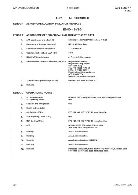
<strong>AIP</strong> SVERIGE/SWEDEN 12 DEC 2013AD 2 <strong>ES</strong>ND 1-1SVEGAD 2AERODROM<strong>ES</strong><strong>ES</strong>ND 2.1AERODROME LOCATION INDICATOR AND NAME<strong>ES</strong>ND – SVEG<strong>ES</strong>ND 2.2AERODROME GEOGRAPHICAL AND ADMINISTRATIVE DATA1. ARP coordinates and site at AD 620252N 0142527E RWY 687 m from THR 272. Direction and distance from (city) NE 2.4 NM from Sveg3. Elevation/Reference temperature 1178 ft/+16.6°C4. Geoid undulation at AD ELEV PSN 109 ft5. MAG VAR/Annual change 4° E 2015/+0.1 increasing6. Administration, address, telephone, fax, AFS Härjedalens kommunHärjedalen Sveg AirportSE-842 80 SvegTEL: +46 (0)680 71 13 50FAX: +46 (0)680 131 30E-mail: airport@herjedalen.seAFS: <strong>ES</strong>NDZTZXWebsite: herjedalen.se/airport7. Types of traffic permitted (IFR/VFR) IFR/VFR. Max RWY ref code 2C8. Remarks -<strong>ES</strong>ND 2.3OPERATIONAL HOURS1. AD AdministrationAD Operating hoursMON-FRI 0530-2000 (0430-1900), SUN 1500-2000 (1400-1900)H242. Customs and immigration O/R3. Health and sanitation -4. AIS Briefing Office FPC H24, +46 (0)8 797 63 40, www.lfv.se/fpc5. ATS Reporting Office (ARO) H246. MET Briefing Office FPC H24, +46 (0)8 797 63 40, www.lfv.se/fpc7. ATS AFIS for SKED TFC, other O/R from ADAdministration +46 (0)680 71 13 518. Fuelling As AD Administration9. Handling As AD Administration10. Security As AD Administration. 24 HR PN11. De-Icing As AD Administration12. Remarks Increased charges MON-FRI 2000-0530 (1900-0430), SAT H24, SUN0000-1500 (2300-1400), 2000-2400 (1900-2300)LFV AIRAC AMDT 7/2013
AD 2 <strong>ES</strong>ND 1-2SVEG12 DEC 2013<strong>AIP</strong> SVERIGE/SWEDEN<strong>ES</strong>ND 2.4HANDLING SERVIC<strong>ES</strong> AND FACILITI<strong>ES</strong>1. Cargo-handling facilities -2. Fuel/oil types Fuel Jet A1, 100LLOil Piston oil3. Fuelling facilities/discharge capacity Jet A1: 50,000 l in stationary unit and 20,000 l infuel truck100LL: 20,000 l in stationary unit4. De-icing facilities Available, Type I and II5. Hangar space for visiting ACFT -6. Repair facilities for visiting ACFT -7. Remarks -<strong>ES</strong>ND 2.5PASSENGER FACILITI<strong>ES</strong>1. Hotels In Sveg2. Restaurants In Sveg3. Transportation Taxis, rental cars4. Medical facilities In Sveg5. Bank and Post Office In Sveg6. Tourist Office In Sveg7. Remarks -<strong>ES</strong>ND 2.6R<strong>ES</strong>CUE AND FIRE FIGHTING SERVIC<strong>ES</strong>1. AD category for fire fighting Cat 3 for SKED TFC, up to CAT 6 O/R 24 HR PN+46 (0)680 71 13 502. Rescue equipment By arrangement, municipal rescue service3. Capability for removal of disabled aircraft By arrangement4. Remarks -<strong>ES</strong>ND 2.7SEASONAL AVAILABILITY – CLEARING1. Types of clearing equipment Blowers, sweepers, slingers2. Clearance priorities RWY, TWY, Apron3. Remarks Normally no clearing SAT and HOL<strong>ES</strong>ND 2.8APRONS, TAXIWAYS AND CHECK LOCATIONS DATA1. Apron surface and strength Apron ASPH PCN 12 F/B/X/U2. Taxiway width, surface and strength TWY A 15 m ASPH PCN 12 F/B/X/U3. ACL, location and elevation Apron 1172 ft4. VOR checkpoints -5. INS checkpoints -6. Remarks -AIRAC AMDT 7/2013LFV
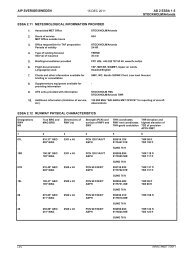
<strong>AIP</strong> SVERIGE/SWEDEN 12 DEC 2013AD 2 <strong>ES</strong>ND 1-3SVEG<strong>ES</strong>ND 2.9SURFACE MOVEMENT GUIDANCE AND CONTROL SYSTEM AND MARKINGS1. Use of aircraft stand ID signs, TWY guidelines and visual docking/parking guidancesystem of ACFT stands-2. RWY and TWY markings and LGT RWY 09/27: Designator, THR and CL are day marked.RTHL, REDL, RENLTWY A:CL, HLDG, day marked. Edge lights, RGL3. Stop bars -4. Remarks -<strong>ES</strong>ND 2.10 AERODROME OBSTACL<strong>ES</strong>In Area 2OBST ID/Designation OBST type OBST position ELEV/HGT Markings/ Type,colourRemarksNot availablea b c d e fIn Area 3OBST ID/Designation OBST type OBST position ELEV/HGT Markings/ Type,colourRemarksNot availablea b c d e f<strong>ES</strong>ND 2.11 METEOROLOGICAL INFORMATION PROVIDED1. Associated MET Office STOCKHOLM/Arlanda2. Hours of serviceMET Office outside hours3. Office responsible for TAF preparationPeriods of validity4. Type of landing forecastInterval of issuanceH24TAF not producedNot issued5. Briefing/consultation provided FPC H24, +46 (0)8 797 63 40, www.lfv.se/fpc6. Flight documentationLanguage(s) used7. Charts and other information available forbriefing or consultation8. Supplementary equipment available forproviding informationSIGMET, Upper air windsSwedish/EnglishSWC, WC, Nordic SIGWX Chart, Low level forecast-9. ATS units provided with information SVEG AFIS10. Additional information (limitation of service,etc.)-LFV AIRAC AMDT 7/2013
AD 2 <strong>ES</strong>ND 1-4SVEG12 DEC 2013<strong>AIP</strong> SVERIGE/SWEDEN<strong>ES</strong>ND 2.12 RUNWAY PHYSICAL CHARACTERISTICSDesignationsRWYNRTrue BRG andMAG BRGDimensions ofRWY (m)Strength (PCN) andsurface of RWY andSWYTHR coordinatesRWY end coordinatesTHR geoid undulationTHR elevation andhighest elevation ofTDZ of precisionAPCH RWY1 2 3 4 5 609 086.86° GEO083° MAG1702 x 30 PCN 12 F/B/X/UASPH620250.41N0142417.26ETHR 1172 ftGUND 109 ft27 266.89° GEO263° MAG1702 x 30 PCN 12 F/B/X/UASPH620253.24N0142614.21ETHR 1176 ftGUND 109 ftSlope ofRWY-SWYSWYdimensions (m)CWYdimensions (m)Stripdimensions (m)OFZRemarks7 8 9 10 11 1209 See <strong>ES</strong>ND AOC - - 1822 x 150 - -27 See <strong>ES</strong>ND AOC - - 1822 x 150 - -<strong>ES</strong>ND 2.13 DECLARED DISTANC<strong>ES</strong>RWY Designator TORA (m) TODA (m) ASDA (m) LDA (m) Remarks1 2 3 4 5 609 1702 1702 1702 1702 -27 1702 1702 1702 1702 -<strong>ES</strong>ND 2.14 APPROACH AND RUNWAY LIGHTINGRWYDesignatorAPCH LGTType, LENINTSTTHR LGTColourWBARVASIS(MEHT)TDZ LGTLENRWY CentreLine LGTLEN, SpacingColourINTSTRWY EdgeLGTLEN, SpacingColourINTSTRWY EndLGTColourWBARSWY LGTLEN,Colour1 2 3 4 5 6 7 8 909 SALS420 mLIL/LIHGreenPAPILeft/3.00°(50.0 ft)- - 1702/60 mWhiteCaution zone575 m yellowLIL/LIHRed -27 - Green PAPILeft/3.00°(50.0 ft)- - 1702/60 mWhiteCaution zone575 m yellowLIL/LIHRed -10 Remarks: RWY 09: PCL LIL RWY on frequency 122.20 MHz for 20 SEC.RWY 27: PCL LIL RWY on frequency 122.20 MHz for 20 SEC.AIRAC AMDT 7/2013LFV
<strong>AIP</strong> SVERIGE/SWEDEN 12 DEC 2013AD 2 <strong>ES</strong>ND 1-5SVEG<strong>ES</strong>ND 2.15 OTHER LIGHTING, SECONDARY POWER SUPPLY1. ABN/IBN location, characteristics andhours of operation2. LDI location and LGTAnemometer location and LGT-Lighted windsock W apronAt RWY ends, lighted3. TWY edge and centre line lighting Edge: TWY ACL: -4. Secondary power supply/switch-over time Available/10 sec5. Remarks -<strong>ES</strong>ND 2.16 HELICOPTER LANDING AREARWY 09/27 to be used<strong>ES</strong>ND 2.17 ATS AIRSPACE1. Designation and lateral limits SVEG TIA 620937N 0134909E - 620938N 0145251E -615440N 0145237E - 615439N 0134927E -620937N 0134909<strong>ES</strong>VEG TIZ 620736N 0142500E - 620502N 0144000E -620124N 0144023E - 615809N 0142601E -620105N 0140547E - 620339N 0140529E -620736N 0142500E2. Vertical limits SVEG TIA 6000 ft AMSL⎯⎯⎯⎯⎯⎯⎯⎯1000 ft GNDSVEG TIZ1000 ft GND⎯⎯⎯⎯⎯⎯⎯⎯GND3. Airspace classification TIA GTIZ G4. ATS unit call signLanguage(s)SVEG INFORMATIONSwedish/English5. Transition altitude 6000 ft AMSL6. Remarks TIA established during hours of AFIS.TIZ established during hours of AFIS.<strong>ES</strong>ND 2.18 ATS COMMUNICATION FACILITI<strong>ES</strong>Service designation Call sign Frequency Hours of operation Remarks1 2 3 4 5AFIS SVEG INFORMATION 122.200 MHz HO -121.500 MHz HO -LFV AIRAC AMDT 7/2013
AD 2 <strong>ES</strong>ND 1-6SVEG12 DEC 2013<strong>AIP</strong> SVERIGE/SWEDEN<strong>ES</strong>ND 2.19 RADIO NAVIGATION AND LANDING AIDSType of aidCAT of ILS/MLS(for VOR/ILS/MLSgive VAR)ID Frequency Hours ofoperationSite oftransmittingantennacoordinatesElevation of DMEtransmittingantennaRemarks1 2 3 4 5 6 7LOC 09(4° E 2015)IND 109.10 MHz H24 620253.6N0142628.6E360 m beyond THR 27LO 09 OY 368 kHz H24 620243.5N0141934.0ELI 09 Y 327 kHz H24 620249.5N0142341.4EDME SVE 113.95 MHz H24 620247.2N0142443.4ERange 30 NMRange 15 NM1175 ft DME channel 86Y<strong>ES</strong>ND 2.20 LOKALA TRAFIKFÖR<strong>ES</strong>KRIFTERÖverflygning av Sveg samhälle bör undvikas.Efter start RWY 27 får vänstersväng inte påbörjas förrän enhöjd av 2500 ft AMSL har uppnåtts.LOCAL TRAFFIC REGULATIONSOverflying of the built up areas of Sveg should be avoided.After take-off RWY 27 left hand turn must not be initiated untilan altitude of 2500 ft AMSL has been reached.<strong>ES</strong>ND 2.21 MINSKNING AV BULLERSTÖRNINGNILNOISE ABATEMENT PROCEDUR<strong>ES</strong>NIL<strong>ES</strong>ND 2.22 FLYGPROCEDURERStartprocedurer, omnidirectionalFLIGHT PROCEDUR<strong>ES</strong>Omnidirectional departure proceduresRWYProcedure09 Climb straight ahead to MNM turning ALT 2000 ft.Continue climb to appropriate MSA.Sector 188° – 218° GEO from ARP not to be entered untilALT 3600 ft is reached.ObstacleTerrainPylonSignificant obstacleDirection (GEO)/Dist (m)Elevation (ft)from THR16903383060°/4500202°/1480027 Climb straight ahead with MNM 250 ft/NM (4.0%) to MNMturning ALT 2300 ft.Continue climb to appropriate MSA.Sector 188° – 218° GEO from ARP not to be entered untilALT 3600 ft is reached.TerrainTerrainTerrainPylon1752213322483383287°/8500312°/11000228°/10900205°/15300<strong>ES</strong>ND 2.23 ÖVRIG INFORMATIONNILADDITIONAL INFORMATIONNIL<strong>ES</strong>ND 2.24 TILLHÖRANDE KARTORRELATED CHARTSAD chart <strong>ES</strong>ND 2-1AOC RWY 09/27 <strong>ES</strong>ND-3-1IAC LOC RWY 09 <strong>ES</strong>ND 5-1IAC NDB RWY 09 <strong>ES</strong>ND 5-2VAC <strong>ES</strong>ND 6-1AIRAC AMDT 7/2013LFV


