Application of Seamless Simulation of Seismic Response Analysis ...
Application of Seamless Simulation of Seismic Response Analysis ...
Application of Seamless Simulation of Seismic Response Analysis ...
- No tags were found...

Create successful ePaper yourself
Turn your PDF publications into a flip-book with our unique Google optimized e-Paper software.
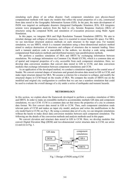
simulating each phase <strong>of</strong> an urban disaster. Each component simulation uses physics-basedcomputational methods with input city models that reflect the actual properties <strong>of</strong> a city, constructedfrom data stored in the Geographic Information System (GIS). In the past, the main development <strong>of</strong>INDS was targeted on earthquake disasters (Integrated Earthquake Simulator, IES). IES integratesseismic wave propagation analysis from the fault to city, <strong>Seismic</strong> <strong>Response</strong> <strong>Analysis</strong> (SRA) <strong>of</strong>structures using the computed SGM, and simulation <strong>of</strong> evacuation processes using Multi Agent<strong>Simulation</strong>.In this paper, we integrate SRA and High Resolution Tsunami <strong>Simulation</strong> (HRTS). We aim tosimulate damage and collapse <strong>of</strong> structures, since it is essential to ensure human life space. For SRA,we use non-linear structural analysis methods on each structure in the target area. For tsunamisimulation, we use HRTS, which is a tsunami simulation using a three-dimensional analysis methodaimed to analyze destruction <strong>of</strong> structures and collapse <strong>of</strong> structures due to tsunami loading. Sincesuch a tsunami analysis code is unavailable to the authors, we develop a code using standardcomputational fluid analysis methods and distributed memory type parallelization methods.We perform a seamless simulation <strong>of</strong> SRA and HRTS by exchanging information betweensimulations. We exchange information via Common City Model (CCM), which is a common data set<strong>of</strong> spatial and temporal properties <strong>of</strong> a city, accessible from each component simulation. Here, wedevelop data conversion modules that convert data stored in GIS to CCM, and data conversionmodules that exchange information between component simulations and CCM.As an application <strong>of</strong> the developed method, we conduct a simulation targeted on the coastal area <strong>of</strong>Sendai. We convert external shapes <strong>of</strong> structures and ground elevation data stored in GIS to CCM, andmake input structure dataset for SRA. We assume a criterion for a structure to collapse, and modify thestructural shapes in CCM based on the results <strong>of</strong> SRA. We compare the results <strong>of</strong> HRTS run on themodified and original city configuration to confirm that we can run a seamless simulation that couldbe used to evaluate the overall damage <strong>of</strong> a city under a series <strong>of</strong> earthquake and tsunami hazards.METHODOLOGYIn this section, we explain about the framework developed to perform a seamless simulation <strong>of</strong> SRAand HRTS. In order to make an extendible method to accommodate multiple GIS data and componentsimulations, we use CCM. CCM is a common data set that stores the properties <strong>of</strong> a city in commondata format. We first convert data stored in GIS to CCM. Then, each component simulation readsrelevant parts <strong>of</strong> CCM and makes an input city model, analyzes and writes the modifications to thecity model back to CCM; see Fig.1. By using a common data set <strong>of</strong> a city, we can integrate simulationswithout the hassle to make direct data conversion modules between each component simulation. Thefollowing are the details <strong>of</strong> the conversion methods and analysis methods used in this paper.We convert elevation and structure data stored in GIS to CCM. Here, we develop modules thatconvert Digital Elevation Map (DEM) and two-dimensional vector structure data to CCM; see arrow(i) and (ii) in Fig. 1.GIS datacomponentsimulationsDEM2D vectordata(i)(ii)CCM(iii)(v)(iv)SRAHRTSFig. 1 Design <strong>of</strong> INDS using CCM541