Ashes Hollow - Field Studies Council
Ashes Hollow - Field Studies Council
Ashes Hollow - Field Studies Council
- No tags were found...

You also want an ePaper? Increase the reach of your titles
YUMPU automatically turns print PDFs into web optimized ePapers that Google loves.
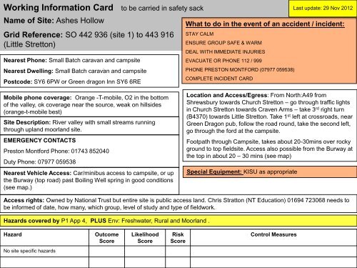
Working Information Card to be carried in safety sack Last update: 29 Nov 2012Name of Site: <strong>Ashes</strong> <strong>Hollow</strong>Grid Reference: SO 442 936 (site 1) to 443 916(Little Stretton)Nearest Phone: Small Batch caravan and campsiteNearest Dwelling: Small Batch caravan and campsitePostcode: SY6 6PW or Green dragon Inn SY6 6REWhat to do in the event of an accident / incident:STAY CALMENSURE GROUP SAFE & WARMDEAL WITH IMMEDIATE INJURIESEVACUATE OR PHONE 112 / 999PHONE PRESTON MONTFORD (07977 059538)COMPLETE INCIDENT CARDMobile phone coverage: Orange -T-mobile, O2 in the bottomof the valley, ok coverage near the source, weak on hillsides(orange-t-mobile best)Site Description: River valley with small streams runningthrough upland moorland site.EMERGENCY CONTACTSPreston Montford Phone: 01743 852040Duty Phone: 07977 059538Nearest Vehicle Access: Car/minibus access to campsite, or upthe Burway (top road) past Boiling Well spring in good conditions(see map.)Location and Access/Egress: From North:A49 fromShrewsbury towards Church Stretton – go through traffic lightsin Church Stretton towards Craven Arms – take 3 rd right turn(B4370) towards Little Stretton. Take 1 st left at crossroads, nearGreen Dragon pub, follow the road round, take the second left,go through the ford at the campsite.Footpath through Campsite, takes about 20-30mins over rockyground to top fieldsite. Access also possible from the Burway atthe top in about 20 – 30 mins (see map)Special Equipment: KISU as appropriateAccess rights: Owned by National Trust but entire site is public access land. Chris Stratton (NT Education) 01694 723068 needs tobe informed of date, how many, which group, level of study and type of fieldwork.Hazards covered by P1 App 4, PLUS Env: Freshwater, Rural and Moorland .HazardOutcomeScoreLikelihoodScoreRiskScoreControl MeasuresNo site specific hazards
Working Information Card to be carried in safety sackPath to sitePossible egressroutesPossible alternativesite using tributary.Name of Site: <strong>Ashes</strong> <strong>Hollow</strong>Grid Reference: SO 442 936 (site 1) to 443 916(Little Stretton)Burway; very steep, no accessfor coaches. Do not use in icyor very wet conditions.Two higher paths,avoiding lowergorge section.Select lower or higher routearound gorge section dependingon conditions, group size, abilityand previous experience.Path through lowergorge section.Advise students of appropriatebehaviour near dwellings andcampsite. Remind students ofrocky sections and otherhazards as appropriate.Keep group to path whenwalking through campsiteNearestdwellingMinibus parkingby streamCoach drop-off; GreenDragon pub.Park by bus stop/laybyand limit time in theareaTraffic risk whenloading/unloading andwalking to campsite.