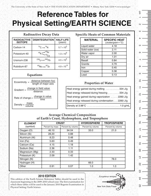
Reference Tables for Physical Setting/EARTH ... - Mrsciguy.com
Reference Tables for Physical Setting/EARTH ... - Mrsciguy.com
Reference Tables for Physical Setting/EARTH ... - Mrsciguy.com

Create successful ePaper yourself
Turn your PDF publications into a flip-book with our unique Google optimized e-Paper software.
Taconic MountainsNew England Province(Highlands)LowlandsChamplainGeneralized Landscape Regions of New York StateSt. Lawrence LowlandsGrenville Province(Highlands)Interior LowlandsAdirondackMountainsTug HillPlateauErie-Ontario Lowlands(Plains)Allegheny PlateauAtlantic Coastal PlainManhattan ProngHudson HighlandsAppalachian Plateau (Uplands)Lake ErieInteriorLowlandsLake OntarioHudson-Mohawk LowlandsThe CatskillsKeyNewarkLowlandsMajor geographic province boundaryLandscape region boundaryState boundaryInternational boundaryMiles0 10 20 30 40 500 20 40 60 80KilometersNW ES2 <strong>Physical</strong> <strong>Setting</strong>/Earth Science <strong>Reference</strong> <strong>Tables</strong> — 2010 Edition
ISLAND SOUNDLONGGeneralized Bedrock Geology of New York Statemodified fromGEOLOGICAL SURVEYNEW YORK STATE MUSEUM1989Niagara RiverGEOLOGIC PERIODS AND ERAS IN NEW YORKCRETACEOUS and PLEISTOCENE (Epoch) weakly consolidated to unconsolidated gravels, sands, and claysLATE TRIASSIC and EARLY JURASSIC conglomerates, red sandstones, red shales, basalt, and diabase (Palisades sill)PENNSYLVANIAN and MISSISSIPPIAN conglomerates, sandstones, and shalesDEVONIAN limestones, shales, sandstones, and conglomeratesSILURIAN SILURIAN also contains salt, gypsum, and hematite.ORDOVICIANCAMBRIAN}}limestones, shales, sandstones, and dolostonesCAMBRIAN and EARLY ORDOVICIAN sandstones and dolostonesmoderately to intensely metamorphosed east of the Hudson RiverCAMBRIAN and ORDOVICIAN (undifferentiated) quartzites, dolostones, marbles, and schistsintensely metamorphosed; includes portions of the Taconic Sequence and Cortlandt ComplexTACONIC SEQUENCE sandstones, shales, and slatesslightly to intensely metamorphosed rocks of CAMBRIAN through MIDDLE ORDOVICIAN agesMIDDLE PROTEROZOIC gneisses, quartzites, and marblesLines are generalized structure trends.MIDDLE PROTEROZOIC anorthositic rocks}}}DominantlysedimentaryoriginDominantlymetamorphosedrocksIntensely metamorphosed rocks(regional metamorphism about 1,000 m.y.a.)Miles0 10 20 30 40 500 20 40 60 80KilometersNW ES<strong>Physical</strong> <strong>Setting</strong>/Earth Science <strong>Reference</strong> <strong>Tables</strong> — 2010 Edition 3
80°60°40°20°0°20°40°60°80°Surface Ocean Currents20° 40° 60° 80° 100° 120° 140° 160° 180° 160° 140° 120° 100° 80° 60° 40° 20° 0° 20°20° 40° 60° 80° 100° 120° 140° 160° 180° 160° 140° 120° 100° 80° 60° 40° 20° 0° 20°Arctic Circle(66.5° N)Tropic of Cancer(23.5° N)EquatorTropic of Capricorn(23.5° S)Antarctic Circle(66.5° S)NorthEquatorial CountercurrentAfricaAsiaIndiaNorthAmericaSouthAmericaAtlantic C.East Australia C.AustraliaNorthPacificOceanEuropeAfricaNorth Equatorial C.South Equatorial C.IndianOceanArctic OceanPeru C.Antarctic Circumpolar CurrentAntarctic Circumpolar CurrentSouthern OceanGreenlandNorwegian C.East Greenland C.West Greenland C.Kamchatka C.Labrador C.Alaska C.North Pacific C.Oyashio C.Canary C.Gulf Stream C.Florida C.NorthAtlanticOceanCali<strong>for</strong>nia C.Kuroshio C.North Equatorial C.EquatorialCountercurrentNorth Equatorial C.Guinea C.Equatorial CountercurrentSouth Equatorial C.South Equatorial C.Benguela C.Brazil C.SouthPacificOceanSouthAtlanticOceanWest Australia C.Agulhas C.Falkland C.AntarcticaAntarcticaNOTE: Not all surface ocean currents are shown.KeyWarm currentsCool currents4 <strong>Physical</strong> <strong>Setting</strong>/Earth Science <strong>Reference</strong> <strong>Tables</strong> — 2010 Edition
To ngaJuan deFuca PlateNorth AmericanPlateAleutian TrenchYellowstoneHot SpotPhilippinePlateHawaiiHot SpotSan AndreasFaultCocosPlateAfricanPlateMid-Atlantic RidgeEurasianPlateCanaryIslandsHot SpotSouthAmericanPlateCaribbeanPlateArabianPlateGalapagosHot SpotPeru-Chile TrenchIndian-AustralianPlateFiji PlatePacificPlateNazcaPlateEast Pacific RidgeAntarcticPlateAntarcticPlateIcelandHot SpotEurasianPlateMid-Atlantic RidgeTectonic PlatesScotiaPlateSandwichPlateMid-Indian RidgeRiftEast AfricanTasmanHot SpotEaster IslandHot SpotSt. HelenaHot SpotBouvetHot SpotSoutheast Indian RidgeSouthwest IndianRidgeKeyoverridingplateRelative motion atplate boundaryTrans<strong>for</strong>m plate boundary(trans<strong>for</strong>m fault)NOTE: Not all mantle hot spots, plates, andboundaries are shown.Divergent plate boundary(usually broken by trans<strong>for</strong>mfaults along mid-ocean ridges)subductingplateConvergent plate boundary(subduction zone)Complex or uncertainplate boundaryMantlehot spotTrenchM a rianaTrenc h<strong>Physical</strong> <strong>Setting</strong>/Earth Science <strong>Reference</strong> <strong>Tables</strong> — 2010 Edition 5
SEDIMENTARYROCKMetamorphismHeat and/or PressureMETAMORPHICROCKRock Cycle in Earth’s CrustCementationCompaction and/orMeltingMelting(Uplift)Weathering & ErosionHeat and/or PressureMetamorphismand Burial(Uplift)DepositionWeathering & ErosionMeltingMAGMASEDIMENTSErosionSolidificationWeathering & Erosion(Uplift)IGNEOUSROCKPARTICLE DIAMETER (cm)100.010.01.00.10.010.0010.0001Relationship of TransportedParticle Size to Water Velocity0.010.10.0510.510510050STREAM VELOCITY (cm/s)25.66.40.20.0060.00041000500BouldersCobblesPebblesSandSiltClayThis generalized graph shows the water velocityneeded to maintain, but not start, movement. Variationsoccur due to differences in particle density and shape.Scheme <strong>for</strong> Igneous Rock IdentificationCRYSTALSIZETEXTUREIGNEOUS ROCKSENVIRONMENT OF FORMATIONEXTRUSIVE(Volcanic)INTRUSIVE(Plutonic)Obsidian(usually appears black)PumiceVesicular rhyoliteRhyoliteGranitePegmatiteVesicularandesiteAndesiteDioriteBasaltic glassScoriaVesicular basaltBasaltDiabaseGabbroDuniteless than1 mm1 mmto10 mm10 mmorlargerGlassyFineCoarseVerycoarseVesicular(gaspockets)noncrystallinePeridotiteNonvesicularNonvesicularCHARACTERISTICSLIGHTERLOWERFELSIC(rich in Si, Al)100%Potassiumfeldspar(pink to white)COLORDENSITYCOMPOSITIONDARKERHIGHERMAFIC(rich in Fe, Mg)100%MINERAL COMPOSITION(relative by volume)75%50%25%Quartz(clear towhite)Plagioclase feldspar(white to gray)Biotite(black)Amphibole(black)Pyroxene(green)Olivine(green)75%50%25%0%0%6 <strong>Physical</strong> <strong>Setting</strong>/Earth Science <strong>Reference</strong> <strong>Tables</strong> — 2010 Edition
INORGANIC LAND-DERIVED SEDIMENTARY ROCKSTEXTURE GRAIN SIZE COMPOSITIONCOMMENTS ROCK NAME MAP SYMBOLClastic(fragmental)Pebbles, cobbles,and/or bouldersembedded in sand,silt, and/or claySand(0.006 to 0.2 cm)Silt(0.0004 to 0.006 cm)Clay(less than 0.0004 cm)Scheme <strong>for</strong> Sedimentary Rock IdentificationMostlyquartz,feldspar, andclay minerals;may containfragments ofother rocksand mineralsRounded fragmentsAngular fragmentsFine to coarseVery fine grainCompact; may spliteasilyConglomerateBrecciaSandstoneSiltstoneShaleCHEMICALLY AND/OR ORGANICALLY FORMED SEDIMENTARY ROCKS. . . . .. . . .. . . . .. . . .TEXTURE GRAIN SIZE COMPOSITIONCOMMENTS ROCK NAME MAP SYMBOLCrystallineFinetocoarsecrystalsHaliteGypsumDolomiteCrystals fromchemicalprecipitatesand evaporitesRock saltRock gypsumDolostoneCrystalline orbioclasticBioclasticMicroscopic tovery coarseCalciteCarbonPrecipitates of biologicorigin or cemented shellfragmentsCompactedplant remainsLimestoneBituminous coalTEXTUREScheme <strong>for</strong> Metamorphic Rock IdentificationGRAINTYPE OFSIZE COMPOSITION METAMORPHISMCOMMENTS ROCK NAMEMAP SYMBOLFOLIATEDMINERALALIGNMENTBAND-INGFineFinetomediumMediumtocoarseMICAQUARTZFELDSPARAMPHIBOLEGARNETPYROXENERegional(Heat andpressureincreases)Low-grademetamorphism of shaleFoliation surfaces shinyfrom microscopic micacrystalsPlaty mica crystals visiblefrom metamorphism of clayor feldsparsHigh-grade metamorphism;mineral types segregatedinto bandsSlatePhylliteSchistGneissFineCarbonRegionalMetamorphism ofbituminous coalAnthracite coalNONFOLIATEDFineFinetocoarseVariousmineralsQuartzCalcite and/ordolomiteContact(heat)RegionalorcontactVarious rocks changed byheat from nearbymagma/lavaMetamorphism ofquartz sandstoneMetamorphism oflimestone or dolostoneHornfelsQuartziteMarbleCoarseVariousmineralsPebbles may be distortedor stretchedMetaconglomerate<strong>Physical</strong> <strong>Setting</strong>/Earth Science <strong>Reference</strong> <strong>Tables</strong> — 2010 Edition 7
GEOLOGIC HISTORYEonMillion years ago050010002000300040004600PHANERO-ZOICPRECAMBRIANARCHEAN PROTEROZOICLATEMIDDLEEARLYMIDDLELATEEARLYFirstsexuallyreproducingorganismsEraOceanic oxygenbegins to enterthe atmosphereOceanic oxygenproduced bycyanobacteria<strong>com</strong>bines withiron, <strong>for</strong>mingiron oxide layerson ocean floorEarliest stromatolitesOldest microfossilsEvidence of biologicalcarbonOldest known rocksEstimated time of originof Earth and solar systemCENOZOICMESOZOICPALEOZOICQUATERNARYNEOGENEPALEOGENECRETACEOUSJURASSICTRIASSICPERMIANCARBONIF-EROUSPeriod Epoch Life on EarthPENNSYLVANIANMISSISSIPPIANDEVONIANSILURIANORDOVICIANCAMBRIANPLEISTOCENEPLIOCENELATEEARLYLATEMIDDLEEARLYLATEMIDDLEEARLYLATEMIDDLEEARLYLATEEARLYLATEMIDDLEEARLYLATEMIDDLEEARLYLATEEARLYLATEMIDDLEEARLYLATEMIDDLEEARLYMillion years agoHOLOCENE1.85.3MIOCENE23.0OLIGOCENE33.9EOCENE55.8PALEOCENE65.514620025129931835941644448854258000.01Humans, mastodonts, mammothsLarge carnivorous mammalsAbundant grazing mammalsEarliest grassesMany modern groups of mammalsMass extinction of dinosaurs, ammonoids, andmany land plantsEarliest flowering plantsDiverse bony fishesEarliest birdsAbundant dinosaurs and ammonoidsEarliest mammalsEarliest dinosaursMass extinction of many land and marineorganisms (including trilobites)Mammal-like reptilesAbundant reptilesExtensive coal-<strong>for</strong>ming <strong>for</strong>estsAbundant amphibiansLarge and numerous scale trees and seed ferns(vascular plants); earliest reptilesEarliest amphibians and plant seedsExtinction of many marine organismsEarth’s first <strong>for</strong>estsEarliest ammonoids and sharksAbundant fishEarliest insectsEarliest land plants and animalsAbundant eurypteridsInvertebrates dominantEarth’s first coral reefsBurgess shale fauna (diverse soft-bodied organisms)Earliest fishesExtinction of many primitive marine organismsEarliest trilobitesGreat diversity of life-<strong>for</strong>ms with shelly partsEdiacaran fauna (first multicellular, soft-bodiedmarine organisms)NY RockRecordSedimentBedrock(Index fossils not drawn to scale)1300Abundant stromatolitesABC D E F G H I J K L M NCryptolithus Valcouroceras Centroceras Eucalyptocrinus TetragraptusElliptocephala Phacops Hexameroceras Manticoceras CtenocrinusDicellograptusCoelophysis StylonurusEurypterus8 <strong>Physical</strong> <strong>Setting</strong>/Earth Science <strong>Reference</strong> <strong>Tables</strong> — 2010 Edition
OF NEW YORK STATETime Distribution of Fossils(including important fossils of New York)The center of each lettered circle indicates the approximate time ofexistence of a specific index fossil (e.g. Fossil A lived at the endof the Early Cambrian).O SImportant GeologicEvents in New YorkAdvance and retreat of last continental iceInferred Positions ofEarth’s LandmassesNAUTILOIDSDINOSAURSMAMMALSBIRDSSands and clays underlying Long Island andStaten Island deposited on margin of AtlanticOceanDome-like uplift of Adirondack region begins59 million years agoTRILOBITESCFEAMMONOIDSGCRINOIDSIHLGRAPTOLITESEURYPTERIDSNMVASCULAR PLANTSQPPLACODERM FISHRCORALSVUGASTROPODSXBRACHIOPODSZYInitial opening of Atlantic OceanNorth America and Africa separateIntrusion of Palisades sillPangaea begins to break upAlleghenian orogeny caused bycollision of North America andAfrica along trans<strong>for</strong>m margin,<strong>for</strong>ming PangaeaCatskill delta <strong>for</strong>msErosion of Acadian MountainsAcadian orogeny caused by collision ofNorth America and Avalon and closingof remaining part of Iapetus OceanSalt and gypsum deposited in evaporite basins119 million years ago232 million years ago359 million years agoBDKJTWErosion of Taconic Mountains; Queenston delta<strong>for</strong>msTaconian orogeny caused by closingof western part of Iapetus Ocean andcollision between North America andvolcanic island arcAWidespread deposition over most of New Yorkalong edge of Iapetus Ocean458 million years agoRifting and initial opening of Iapetus OceanErosion of Grenville MountainsGrenville orogeny: metamorphism ofbedrock now exposed in the Adirondacksand Hudson HighlandsOPQ R S T U V W X Y ZMastodontBeluga WhaleCooksonia Naples TreeBothriolepisAneurophytonCondor Cystiphyllum Maclurites EospiriferLichenaria Pleurodictyum Platyceras MucrospiriferESC/BW/TN (2009)<strong>Physical</strong> <strong>Setting</strong>/Earth Science <strong>Reference</strong> <strong>Tables</strong> — 2010 Edition 9
Inferred Properties of Earth’s InteriorPACIFICOCEANNORTHAMERICACASCADESTRENCHCRUSTRIGID MANTLE} LITHOSPHEREATLANTIC OCEANASTHENOSPHERE (PLASTIC MANTLE)STIFFERMANTLEMID-ATLANTICRIDGEOUTER CORE(IRON & NICKEL)INNER CORE(IRON & NICKEL)DENSITY (g/cm 3 )2.7 granitic continental crust3.0 basaltic oceanic crustMOHO3.4–5.69.9–12.212.8–13.14<strong>EARTH</strong>’S CENTERPRESSURE(million atmospheres)32107000TEMPERATURE (°C)600050004000300020001000MELTING POINTINTERIOR TEMPERATUREPARTIAL MELTINGMELTING POINT00 1000 2000 3000 4000 5000 6000DEPTH (km)10 <strong>Physical</strong> <strong>Setting</strong>/Earth Science <strong>Reference</strong> <strong>Tables</strong> — 2010 Edition
TRAVEL TIME (min)24232221201918171615141312111098765432100Earthquake P-Wave and S-Wave Travel Time1 2 3 4 5 6 7 8EPICENTER DISTANCE (× 10 3 km)SP9 10<strong>Physical</strong> <strong>Setting</strong>/Earth Science <strong>Reference</strong> <strong>Tables</strong> — 2010 Edition 11
1–33–28–24–21–18–14–12–10–7–5–3–11468101214161921232527292–36–28–22–18–14–12–8–6–3–113681113151719212325270–20–18–16–14–12–10–8–6–4–2024681012141618202224262830–20–18–16–14–12–10–8–6–4–20246810121416182022242628303–29–22–17–13–9–6–4–1146911131517202224264–29–20–15–11–7–4–21469111416182022245–24–17–11–7–5–214791214161821236–19–13–9–5–21471012141719217–21–14–9–5–214710121517198–14–9–5–1248101316189–28–16–10–6–225811141610–17–10–5–2369111411–17–10–5–12691212–19–10–5–1371013–19–10–504814–19–10–41515–18–9–3112840485561667173777981838586878888899091919292929393211233341485458636770727476787980818283848586860100100100100100100100100100100100100100100100100100100100100100100100100100100–20–18–16–14–12–10–8–6–4–2024681012141618202224262830313203237455156596265676971727475767778794112028364246515457606264666869707172511120273539434850545658606264656666142228333841454851535557596171017242833374044464951535586131925293336404245474994101621263033363942441028141923273034363911171217212528313412161115202326291351014182125144913172015491216Difference Between Wet-Bulb and Dry-Bulb Temperatures (C°)Difference Between Wet-Bulb and Dry-Bulb Temperatures (C°)Dry-BulbTempera -ture (°C)Dry-BulbTempera -ture (°C)Dewpoint (°C)Relative Humidity (%)12 <strong>Physical</strong> <strong>Setting</strong>/Earth Science <strong>Reference</strong> <strong>Tables</strong> — 2010 Edition
Water boilsRoom temperatureStation ModelWater freezesFahrenheit(°F)220200180160140120100806040200–20–40–60TemperatureCelsius(°C)1101009080706050403020100–10–20–30–40–50Kelvin(K)380370360350340330320310300290280270260250240230220Key to Weather Map SymbolsStation Model ExplanationOne atmospheremillibars(mb)1040.0Pressure1036.01032.01028.01024.01020.01016.01012.01008.01004.01000.0996.0992.0988.0984.0980.0inches(in of Hg*)30.7030.6030.5030.4030.3030.2030.1030.0029.9029.8029.7029.6029.5029.4029.3029.2029.1029.0028.90281227196+19/.25976.0972.0968.028.8028.7028.6028.50*Hg = mercuryDrizzleSnowRainSleetPresent Weather Air MassesFronts HurricaneSmogFreezingrainHailFogThunderstormsHazeRainshowersSnowshowerscA continental arcticcP continental polarcT continental tropicalmT maritime tropicalmP maritime polar<strong>Physical</strong> <strong>Setting</strong>/Earth Science <strong>Reference</strong> <strong>Tables</strong> — 2010 Edition 13ColdWarmStationaryOccludedTornado
km mi140 100TemperatureZonesAtmosphericPressureSelectedProperties ofEarth’sAtmosphere120 75Thermosphere(extends to 600 km)Altitude80 50MesopauseMesosphere40 25StratopauseStratosphereWaterVaporSea Level0 0TropopauseTroposphere–100° 0° 100°–90° –55° 15°Temperature(°C)0 1.0Pressure(atm)0 20 40Concentration(g/m 3 )Planetary Wind and MoistureBelts in the TroposphereThe drawing on the right shows thelocations of the belts near the time of anequinox. The locations shift somewhatwith the changing latitude of the Sun’svertical ray. In the Northern Hemisphere,the belts shift northward in the summerand southward in the winter.DRYN.E.WETS.W.WindsDRYN.E.WindsWET60° N30° N0°TropopausePolar front jet streamPolar frontSubtropicaljet streams(Not drawn to scale)S.E.WindsDRYN.W.Winds30° SWETS.E.DRY60° SPolar front jet streamElectromagnetic SpectrumX raysMicrowavesGamma raysUltravioletInfraredRadio wavesDecreasing wavelengthVisible lightViolet Blue Green Yellow Orange RedIncreasing wavelength(Not drawn to scale)14 <strong>Physical</strong> <strong>Setting</strong>/Earth Science <strong>Reference</strong> <strong>Tables</strong> — 2010 Edition
Luminosity(Rate at which a star emits energy relative to the Sun)CelestialObjectMean Distancefrom Sun(million km)Period ofRevolution(d=days) (y=years)Solar System DataPeriod ofRotation at EquatorEccentricityof OrbitEquatorialDiameter(km)Mass(Earth = 1)Density(g/cm 3 )SUN — — 27 d — 1,392,000 333,000.00 1.4MERCURY 57.9 88 d 59 d 0.206 4,879 0.06 5.4VENUS 108.2 224.7 d 243 d 0.007 12,104 0.82 5.2<strong>EARTH</strong> 149.6 365.26 d 23 h 56 min 4 s 0.017 12,756 1.00 5.5MARS 227.9 687 d 24 h 37 min 23 s 0.093 6,794 0.11 3.9JUPITER 778.4 11.9 y 9 h 50 min 30 s 0.048 142,984 317.83 1.3SATURN 1,426.7 29.5 y 10 h 14 min 0.054 120,536 95.16 0.7URANUS 2,871.0 84.0 y 17 h 14 min 0.047 51,118 14.54 1.3NEPTUNE 4,498.3 164.8 y 16 h 0.009 49,528 17.15 1.8<strong>EARTH</strong>’SMOON1,000,000100,00010,0001,0001001010.10.010.0010.000130,000149.6(0.386 from Earth)Characteristics of Stars(Name in italics refers to star represented by a .)(Stages indicate the general sequence of star development.)Spica40 Eridani BRigelMAIN SEQUENCE(Early stage)WHITE DWARFS(Late stage)SiriusDenebSUPERGIANTS(Intermediate stage)PolarisSunProcyon B20,000 10,000 8,000 6,000 4,000 3,000Surface Temperature (K)Blue Blue White White YellowColorBetelgeuseGIANTS(Intermediate stage)PolluxAlpha CentauriAldebaranOrangeBarnard’sStarProximaCentauriRed2,000MassiveStarsSmallStars27.3 d 27.3 d 0.055 3,476 0.01 3.3<strong>Physical</strong> <strong>Setting</strong>/Earth Science <strong>Reference</strong> <strong>Tables</strong> — 2010 Edition 15
HARD- COMMON DISTINGUISHINGLUSTER NESS COLORS CHARACTERISTICS USE(S) COMPOSITION* MINERAL NAMEMetallic lusterEitherNonmetallic luster1–2✔2.5 ✔5.5–6.5 ✔6.5 ✔5.5 – 6.5or 11 ✔✔2 ✔2 ✔2–2.5 ✔2.5 ✔2.5–3 ✔3 ✔3.5 ✔4 ✔5–6 ✔5.5 ✔6 ✔6 ✔CLEAVAGEFRACTURE6.5 ✔7 ✔6.5–7.5 ✔silver tograymetallicsilverblack tosilverbrassyyellowmetallic silver orearthy redwhite togreenyellow toamberwhite topink or graycolorless toyellowcolorless towhiteblack todark browncolorlessor variablecolorlessor variablecolorless orvariableblack todark greenblack todark greenwhite topinkwhite tograygreen togray or browncolorless orvariabledark redto greenblack streak,greasy feelgray-black streak, cubic cleavage,density = 7.6 g/cm 3black streak,magneticgreen-black streak,(fool’s gold)red-brown streakgreasy feelpencil lead,lubricantsore of lead,batteriesore of iron,steelore ofsulfurore of iron,jewelryceramics,paperCPbSFe 3 O 4FeS 2Fe 2 O 3Mg 3 Si 4 O 10 (OH) 2GraphiteGalenaMagnetitePyriteHematitewhite-yellow streak sulfuric acid S Sulfureasily scratchedby fingernailflexible inthin sheetscubic cleavage,salty tasteflexible inthin sheetsbubbles with acid,rhombohedral cleavagebubbles with acidwhen powderedcleaves in4 directionscleaves in2 directions at 90°cleaves at56° and 124°cleaves in2 directions at 90°cleaves in 2 directions,striations visible<strong>com</strong>monly light greenand granularglassy luster, may <strong>for</strong>mhexagonal crystalsoften seen as red glassy grainsin NYS metamorphic rocksplaster of paris,drywallCaSO 4 •2H 2 OTalcSelenite gypsumpaint, roofing KAl 3 Si 3 O 10 (OH) 2 Muscovite micafood additive,melts iceconstructionmaterialscement,limebuildingstoneshydrofluoricacidmineral collections,jewelrymineral collections,jewelryceramics,glassceramics,glassfurnace bricks,jewelryglass, jewelry,electronicsjewelry (NYS gem),abrasivesNaClK(Mg,Fe) 3AlSi 3 O 10 (OH) 2CaCO 3CaMg(CO 3) 2CaF 2(Ca,Na) (Mg,Fe,Al)(Si,Al) 2 O 6CaNa(Mg,Fe) 4 (Al,Fe,Ti) 3Si 6 O 22 (O,OH) 2KAlSi 3 O 8(Na,Ca)AlSi 3 O 8(Fe,Mg) 2 SiO 4SiO 2Fe 3 Al 2 Si 3 O 12*Chemical symbols: Al = aluminum Cl = chlorine H = hydrogen Na = sodium S = sulfurC = carbon F = fluorine K = potassium O = oxygen Si = siliconCa = calcium Fe = iron Mg = magnesium Pb = lead Ti = titanium✔ = dominant <strong>for</strong>m of breakageProperties of Common MineralsHaliteBiotite micaCalciteDolomiteFluoritePyroxene(<strong>com</strong>monly augite)Amphibole(<strong>com</strong>monly hornblende)Potassium feldspar(<strong>com</strong>monly orthoclase)Plagioclase feldsparOlivineQuartzGarnet16 <strong>Physical</strong> <strong>Setting</strong>/Earth Science <strong>Reference</strong> <strong>Tables</strong> — 2010 Edition