KPB Surveyor - Kenai Peninsula Borough
KPB Surveyor - Kenai Peninsula Borough
KPB Surveyor - Kenai Peninsula Borough
- No tags were found...

You also want an ePaper? Increase the reach of your titles
YUMPU automatically turns print PDFs into web optimized ePapers that Google loves.
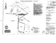
1 INTRODUCTION1.1 BackgroundThe Village of Voznesenka proposes to build a water storage tank and water treatment buildingto serve the Voznesenka Water System. The site is part of a 132-acre tract owned by Chrisand Mike Rainwater in Sections 26 and 27, Town 4 South, Range 11 West, Seward Meridiannorth of Voznesenka and east of Homer, Alaska, near the intersection of East End Road andRainwater Lane. The site of interest consists of approximately 4 acres and has noimprovements. The site has been previously logged and is shown on the test hole location map(Appendix A).Snow, wind, and seismic loads for the proposed terminal are considered typical of the Homerbench/Caribou Hills area. Recommended design snow and wind loads are 80 psf and 130 mph(3 second gust) Exposure C, respectively. Voznesenka is in UBC Seismic Zone 4.Mike Tauriainen, P.E. Consulting Engineers, Inc. (MTPE) performed a foundation soils;investigation on 27 March 02 for the proposed water storage tank site. A partial topographicsurvey of the site with two-foot contour intervals was performed by Ability Surveys. Additionaltopo information will be collected by Ability.1.2 ScopeWe have conducted a subsurface soils investigation, laboratory testing and analysis of the datasufficient to prepare this report of soil and groundwater conditions encountered, foundation soilcharacteristics, static bearing, static settlement and general site preparation and foundationrecommendations for the proposed improvements.The proposed improvements include a 320,OOO-gallon water storage tank, a single-story watertreatment building with spread footings and a slab-on-grade floor, access drive andunderground water main. Foundation and floor loads are expected to be relatively light tomoderate. Normal traffic loads are expected to be autos and light trucks.2 SITE TOPOGRAPHIC, GEOMORPHIC AND GEOLOGIC CONDITIONSThe site is gently to moderately sloping to the south and east. Total site relief is about twentyfivefeet. Site elevation is approximately 1330 -1350 feet above mean sea level. The site hasbeen previously logged and is vegetated with a few small trees and native grasses.