Case Study: 1. The Clarence River Catchment
Case Study: 1. The Clarence River Catchment
Case Study: 1. The Clarence River Catchment

You also want an ePaper? Increase the reach of your titles
YUMPU automatically turns print PDFs into web optimized ePapers that Google loves.
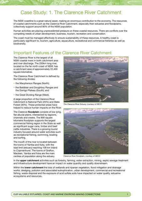
<strong>Case</strong> <strong>Study</strong>: <strong>1.</strong> <strong>The</strong> <strong>Clarence</strong> <strong>River</strong> <strong>Catchment</strong><strong>The</strong> NSW coastline is a great natural asset, making an enormous contribution to the economy. <strong>The</strong> resourcesof coastal catchments such as the <strong>Clarence</strong> <strong>River</strong> <strong>Catchment</strong>, especially their estuaries and floodplains,collectively support around 90% of the NSW population.Human activities are placing unprecedented pressure on these coastal resources. <strong>The</strong>re are conflicts over thecompeting needs of urban development, business, tourism, recreation and conservation.<strong>The</strong> coast must be managed effectively to ensure sustainability of these resources. A healthy coast isparticularly significant to, tourism, agriculture, aquaculture, recreational and commercial fisheries as well asbiodiversity.Important Features of the <strong>Clarence</strong> <strong>River</strong> <strong>Catchment</strong><strong>The</strong> <strong>Clarence</strong> <strong>River</strong> is the largest of allNSW coastal rivers in both catchment areaand river discharge. <strong>The</strong> 250km long river,located on the far north coast of NSW, hasa catchment area of approximately 22,400square kilometres.<strong>The</strong> <strong>Clarence</strong> <strong>River</strong> <strong>Catchment</strong> is defined bythe following divides:• the Macpherson Ranges (North);• the Baldblair and Doughboy Ranges andthe Dorrigo Plateau (South); and• the Great Dividing Range (West).A large proportion of the <strong>Clarence</strong> <strong>River</strong><strong>Catchment</strong> is National Park (20%) and StateForest (30%). <strong>The</strong>se protected areas have <strong>The</strong> <strong>Clarence</strong> <strong>River</strong> Estuary, courtesy of DECChelped to reduce human impacts on the <strong>River</strong>.<strong>The</strong> <strong>Clarence</strong> floodplain consists of low lying,flat alluvial plains, intersected by lagoons,channels and creeks. <strong>The</strong> 800 squarekilometre floodplain supports the largestcommercial fishing region in the State as wellas significant sugar cane, timber and beefcattle industries. <strong>The</strong>re is a growing touristindustry focused around water activities suchas recreational fishing, swimming, boatingand surfing.<strong>The</strong> mouth of the river is located betweenthe towns of Yamba and Iluka, with thetidal limit (estuary) reaching 108 km inlandto Copmanhurst. <strong>The</strong> towns of Grafton,Maclean, Yamba and Iluka are the maincentres of population along the estuary. <strong>Clarence</strong> <strong>River</strong> floodplain, courtesy of DECCIn the upper catchment activities such as forestry, farming, water extraction, mining, septic sewage treatmentand infrastructure development have an impact on water quantity and quality downstream.Within the lower catchment the loss of wetlands and riparian vegetation, flood mitigation and drainageworks, dredging, pollution and associated eutrophication, urban development, commercial and recreationalfishing, waste disposal and the exposure of acid sulfate soils have impacted on water quality, estuarineecosystems and resources.OUR VALUABLE ESTUARIES, COAST AND MARINE ENVIRONS-MAKING CONNECTIONS 1
Figure <strong>1.</strong>1: <strong>Clarence</strong> <strong>River</strong> <strong>Catchment</strong><strong>The</strong> Lower <strong>Clarence</strong><strong>River</strong> <strong>Catchment</strong> isthe focus area of thisresource<strong>The</strong> <strong>Clarence</strong> <strong>River</strong> <strong>Catchment</strong> and Lower <strong>Clarence</strong> <strong>River</strong> <strong>Catchment</strong>, source: modified from “Independent Inquiry Into <strong>The</strong> <strong>Clarence</strong> <strong>River</strong>System” Final Report November 1999, Healthy <strong>River</strong>s Commission of New South Wales NSWOUR VALUABLE ESTUARIES, COAST AND MARINE ENVIRONS-MAKING CONNECTIONS 3
Snapshot on Important Aquatic Habitats of the Lower<strong>Clarence</strong> <strong>River</strong><strong>The</strong> <strong>Clarence</strong> Estuary has a wealth of aquatichabitats that support many species of fish(e.g. mullet, flathead and bream) as well ascrustaceans and also supports the mostproductive estuarine wild catch fishery in theState. It features:• the 2nd largest area of seagrass (0.826 squarekm of Zostera and Halophilia, excludingRuppia which is sometimes classified asseagrass as well);• the 4th largest area of mangroves(7.653 square kilometres); and• the 8th largest area of saltmarsh (2.91 squarekilometres).Mangrove and saltmarsh are also significanthabitats for waterbirds, many of which arethreatened.<strong>The</strong>se areas have been mapped by NSWDepartment of Primary Industries as part of theNSW Comprehensive Coastal Assessment. Seebelow:http://www.naturalresources.nsw.gov.au/estuaries/inventory/data/vegetation/clarence.shtml<strong>The</strong> Lower <strong>Clarence</strong> <strong>Catchment</strong> also featuressaltwater wetlands (in the estuary) andfreshwater wetlands (just above the estuary).<strong>The</strong>se include:• Wooloweyah Lagoon – covers an area of2390 ha and supports large areas of seagrass,mangroves and saltmarsh. It is an importanthabitat for many species of migratory wadersand commercial fish species.Mangroves in the <strong>Clarence</strong> <strong>River</strong> Estuary, source: <strong>Clarence</strong> ValleyCouncilMangroves and saltmarsh on Wooloweyah Lagoon, source: <strong>Clarence</strong>Valley Council• <strong>The</strong> Broadwater – a large tidal waterbody of the <strong>Clarence</strong> estuary fringed by mangroves and supportingseagrass and saltmarsh communities. It provides a drought refuge for migratory species and is animportant habitat for many commercial fish species.• Everlasting Swamp – a freshwater wetland with vegetation including Swamp Oak, Spike-rush, WaterCouch, Common Reed and Spiny Mudgrass.However, many of these habitats have experienced decline in recent years, with seagrass declining by80% between 1940 and 1986 and by 50% in the last 20 years. This has serious consequences for marinebiodiversity, the viability of the fishing industry and for the community in terms of reduced availability offresh local wild caught seafood in the region.This has largely been caused by agricultural, industrial and urban development through land clearing(particularly removal of vegetation from riverbanks), nutrient and sediment rich runoff from developed land,dredging, land reclamation and flood mitigation works.Thus it is important to understand that all activities within a catchment cumulatively impact on land andwater resources downstream, particularly on aquatic habitats including saltmarsh, seagrass, mangrovesand the fisheries they support and thus must be managed to minimise such negative impacts that resultin declines in these habitats (see facts sheets on Estuaries and Land and Water Management in the Lower<strong>Clarence</strong> <strong>River</strong> <strong>Catchment</strong>).4 OUR VALUABLE ESTUARIES, COAST AND MARINE ENVIRONS-MAKING CONNECTIONS
What Are Some of the Natural Resource Management Issuesof the Lower <strong>Clarence</strong> <strong>River</strong> <strong>Catchment</strong>?Some of these issues include:• managing floodplain activities that impact on waterquality in the estuary;• maintaining riparian and estuarine wetlandecosystems necessary to support the professionaland recreational fishing industries;• minimising the impacts of floods on local townsand agricultural productivity without interruptingwater supply;• ensuring sustainable fishing practices;• minimising waste created by different land andwater uses;Fishing boat on the <strong>Clarence</strong> <strong>River</strong>, source: Debra Novak• management of coastal landforms and marineenvironments; and• sustainable urban growth.<strong>The</strong>se issues are being addressed by legislation, policy and a variety of management plans and strategiessuch as Coastal Management Plans (NSW DECC), <strong>Catchment</strong> Action Plans (CMAs), Regional GrowthStrategies (NSW Department of Planning) and Regional Biodiversity Conservation Plans (NSW DECC) and byencouraging many other sustainable practices by everyone operating within the catchment. See fact sheetson Land and Water Management Issues in the Lower <strong>Clarence</strong> <strong>River</strong> <strong>Catchment</strong>, <strong>The</strong> Lower <strong>Clarence</strong> <strong>River</strong><strong>Catchment</strong> Fishing Industry and Waste Management in the Lower <strong>Clarence</strong> <strong>River</strong> <strong>Catchment</strong>.OUR VALUABLE ESTUARIES, COAST AND MARINE ENVIRONS-MAKING CONNECTIONS 5