Little Karoo Biodiversity Assessment - Biodiversity GIS - SANBI
Little Karoo Biodiversity Assessment - Biodiversity GIS - SANBI
Little Karoo Biodiversity Assessment - Biodiversity GIS - SANBI

You also want an ePaper? Increase the reach of your titles
YUMPU automatically turns print PDFs into web optimized ePapers that Google loves.
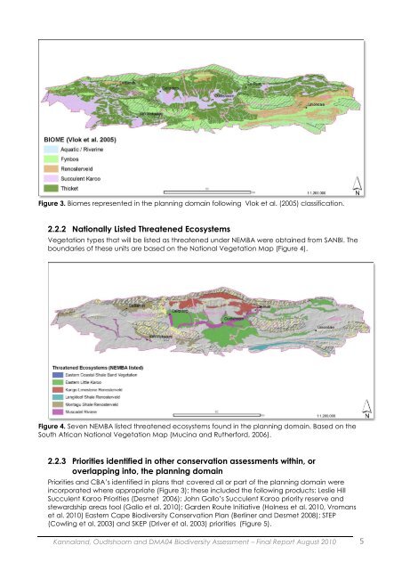
Figure 3. Biomes represented in the planning domain following Vlok et al. (2005) classification.2.2.2 Nationally Listed Threatened EcosystemsVegetation types that will be listed as threatened under NEMBA were obtained from <strong>SANBI</strong>. Theboundaries of these units are based on the National Vegetation Map (Figure 4).Figure 4. Seven NEMBA listed threatened ecosystems found in the planning domain. Based on theSouth African National Vegetation Map (Mucina and Rutherford, 2006).2.2.3 Priorities identified in other conservation assessments within, oroverlapping into, the planning domainPriorities and CBA‟s identified in plans that covered all or part of the planning domain wereincorporated where appropriate (Figure 3); these included the following products: Leslie HillSucculent <strong>Karoo</strong> Priorities (Desmet 2006); John Gallo‟s Succulent <strong>Karoo</strong> priority reserve andstewardship areas tool (Gallo et al. 2010); Garden Route Initiative (Holness et al. 2010, Vromanset al. 2010) Eastern Cape <strong>Biodiversity</strong> Conservation Plan (Berliner and Desmet 2008); STEP(Cowling et al. 2003) and SKEP (Driver et al. 2003) priorities (Figure 5).Kannaland, Oudtshoorn and DMA04 <strong>Biodiversity</strong> <strong>Assessment</strong> – Final Report August 2010 5