- Page 1 and 2: Rare Plants ofShropshire3 rd Editio
- Page 3 and 4: ContentsIntroduction ..............
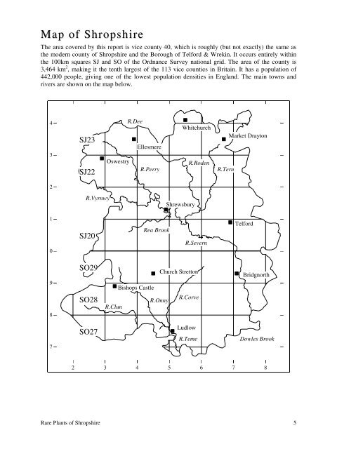
- Page 5: Europe and is apparently declining
- Page 9 and 10: List of recorders & determinersMr G
- Page 11 and 12: Recorders & determiners (cont.)Dr C
- Page 13 and 14: and drainage by eliminating the low
- Page 15 and 16: on the verge of extinction. Just on
- Page 17 and 18: dense bracken and woodland, to whic
- Page 19 and 20: Indicator Species (contd.)Huperzia
- Page 21 and 22: Species AccountsFor each species, t
- Page 23 and 24: Alopecurus aequalis Sobol.Orange Fo
- Page 25 and 26: Arabis glabra L. (Bernh.)Tower must
- Page 27 and 28: A record for Wildmoor Pool (SO4296)
- Page 29 and 30: 43Calamagrostis canescenssince been
- Page 31 and 32: new records for Acton Burnell (SJ53
- Page 33 and 34: Carex acuta L.Slender Tufted-sedgeN
- Page 35 and 36: & Welshpool Naturalists. A record f
- Page 37 and 38: Carex limosa L.Bog-sedgeNative. Ext
- Page 39 and 40: 1880. He described it as occurring
- Page 41 and 42: Farm (SO4990) in 2003. It seems lik
- Page 43 and 44: at the Mere, Ellesmere (SJ4034) and
- Page 45 and 46: 4443210987Clinopodium ascendens2 3
- Page 47 and 48: Serjeantson considered it to be nat
- Page 49 and 50: Dianthus deltoides L.Maiden PinkNat
- Page 51 and 52: Drosera anglica L.Great SundewNativ
- Page 53 and 54: A lowland plant that occurs on the
- Page 55 and 56: Epipactis palustris (L.) CrantzMars
- Page 57 and 58:
Leighton). In 1916 J.B. Duncan also
- Page 59 and 60:
Filipendula vulgaris MoenchDropwort
- Page 61 and 62:
simply ‘near Bridgnorth’ (SO719
- Page 63 and 64:
Leighton (1841) gives records for B
- Page 65 and 66:
(SJ2621) and Blodwel Rocks (SJ2623)
- Page 67 and 68:
and in Shropshire there are still n
- Page 69 and 70:
oth introductions. George Jorden li
- Page 71 and 72:
the list of sites in 1977, and Walk
- Page 73 and 74:
1987 (R.A. Dawes conf. Wainwright);
- Page 75 and 76:
ase-rich clay and limestone chippin
- Page 77 and 78:
43210Legousia hybridaAlthough it is
- Page 79 and 80:
Pool (John Bingham, SO4291, 1984),
- Page 81 and 82:
connected to the canals in about 18
- Page 83 and 84:
8243210987Lycopodium clavatum2 3 4
- Page 85 and 86:
43210987Monotropa hypopitys2 3 4 5
- Page 87 and 88:
Myriophyllum verticillatumNepeta ca
- Page 89 and 90:
In 1984 V.A. Banbury collected it i
- Page 91 and 92:
9043210987Orobanche rapum-genistae2
- Page 93 and 94:
to have been lost to succession as
- Page 95 and 96:
Titterstone Clee (SO5977) in 1854.
- Page 97 and 98:
It was Edward Williams who first di
- Page 99 and 100:
Gordon in 1955. In other parts of t
- Page 101 and 102:
Potamogeton gramineus L.Various-lea
- Page 103 and 104:
in the county, which probably accou
- Page 105 and 106:
at the south end of the mere. This
- Page 107 and 108:
(1841) considered it to be ‘not u
- Page 109 and 110:
Salvia verbenaca L.Wild ClaryArchae
- Page 111 and 112:
Scheuchzeria palustris L.Rannoch-ru
- Page 113 and 114:
[Selaginella selaginoides (L.) Link
- Page 115 and 116:
Rocks and Llynclys Hill, where Sorb
- Page 117 and 118:
Dorothy Evans and Joan Connell foun
- Page 119 and 120:
43210987118Torilis nodosa2 3 4 5 6
- Page 121 and 122:
432109Trollius europaeusLee Brockhu
- Page 123 and 124:
Vaccinium x intermedium Ruthe(Vacci
- Page 125 and 126:
Wahlenbergia hederacea (L.) Rchb.Iv
- Page 127 and 128:
ReferencesAikin, A. 1797. Journal o
- Page 129:
Stace, C.A. 1997. New Flora of the