
Create successful ePaper yourself
Turn your PDF publications into a flip-book with our unique Google optimized e-Paper software.
3<br />
British Isles <strong>Map</strong>s Regional Road <strong>Map</strong> Series<br />
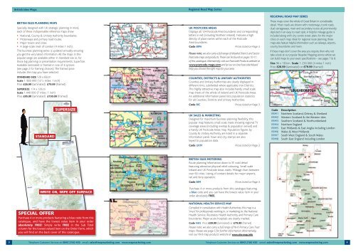
BRITISH ISLES PLANNING MAPS<br />
Specially designed with UK strategic planning in mind,<br />
each of these indispensable reference maps show:<br />
• National, County & Unitary Authority boundaries.<br />
• Motorways and primary road routes.<br />
• Major towns and cities.<br />
• A large-scale inset of London (4 miles:1 inch).<br />
This business planning series is updated annually ensuring<br />
you get the very latest information. All the maps in this<br />
popular range are available either in Standard size or, for<br />
those big planning or presentation requirements, SuperSize.<br />
Available laminated or framed in one of 3 options<br />
(see page 2 for framing choices). The framed price<br />
includes the map you have selected.<br />
STANDARD SIZE 120 x 83cm<br />
Scale 1: 800 000 (121 /2 miles: 1 inch)<br />
Price £26.99 (laminated) £79.99 (framed)<br />
SUPERSIZE 174 x 120cm<br />
Scale 1:440 000 (7 miles: 1 inch)<br />
Price £95.00 (laminated) £150.00 (framed)<br />
STANDARD<br />
SUPERSIZE<br />
WRITE ON, WIPE OFF SURFACE<br />
SPECIAL OFFER<br />
Purchase 4 or more products featuring a blue code from this<br />
catalogue, and have the lowest value item in your order<br />
absolutely FREE! Simply write FREE in the Sub Total<br />
column for the lowest valued item on the Order Form, which<br />
you will find on the back cover of this catalogue.<br />
▲ ▲<br />
▲<br />
▲ ▲<br />
UK POSTCODE AREAS<br />
Displays all 124 Postcode Area boundaries and corresponding<br />
letters in red (including Northern Ireland). Features a high<br />
density of place names within each of the Postcode<br />
Area boundaries.<br />
Code BIPA Prices listed on Page 3.<br />
Please note; we also carry a full range of detailed District and Sector<br />
Postcode maps and products. These can be found on pages 10-11<br />
of this catalogue. Alternatively, visit our Postcode Products website at<br />
www.postcode-maps.com and let our on-line Postcode Wizard<br />
help you choose the right map for your area.<br />
COUNTIES, DISTRICTS & UNITARY AUTHORITIES<br />
Counties and Unitary Authorities are clearly displayed in<br />
different tints, subdivided where applicable into Districts.<br />
This highly attractive map also includes handy small scale<br />
map insets of the whole of Ireland and UK Postcode Areas.<br />
An additional information panel lists population statistics<br />
for all Counties, Districts and Unitary Authorities.<br />
Code BIC Prices listed on Page 3.<br />
UK SALES & MARKETING<br />
Designed for maximum business planning flexibility, this<br />
popular map features small scale insets showing regional TV<br />
coverage areas (including overlap & population served) and<br />
a handy UK Postcode Areas map. Population figures by<br />
County & Unitary Authority are listed in a separate<br />
information panel. Town and city stamps are also<br />
keyed to population data.<br />
Code UKM Prices listed on Page 3.<br />
BRITISH ISLES MOTORING<br />
Route planning information down to ‘B’ road detail<br />
featuring attractive physical relief colouring. Small scale<br />
Ireland and UK Postcode Areas insets. Mileage chart between<br />
over 60 cities. Listing of contact details for major airports,<br />
rail and ferry operators.<br />
Code BIM Prices listed on Page 3.<br />
Purchase 4 or more products from this catalogue featuring<br />
a blue code and you can have the lowest value item in your<br />
order absolutely FREE.<br />
NATIONAL HEALTH SERVICE MAP<br />
Compiled in consultation with Health Authorities, this map is a<br />
‘must’ for professionals working in, or marketing to, the National<br />
Health Service. Illustrates Health Authority and Primary Care<br />
boundaries. Major acute hospitals are clearly marked.<br />
Code NHS Price £39.99 (laminated) or £79.99 (framed)<br />
Please note; we also carry a full range of NHS Primary Care Trust<br />
maps. Please see page 5 for further information. Alternatively,<br />
visit our NHS map products website at www.nhs-map.info<br />
REGIONAL ROAD MAP SERIES<br />
These maps cover the whole of Great Britain in considerable<br />
detail. Most roads are shown with motorways, trunk roads,<br />
dual carriageways, main and secondary routes all prominently<br />
depicted in an easy to read style. A helpful mileage guide is<br />
included along with city centre street plans for the major<br />
cities on each map. Ideal for regional route planning, these<br />
maps also feature helpful information such as railways, airports,<br />
county boundaries and rivers.<br />
If these maps don’t cover the area you require, then why not<br />
take a look at our popular Bespoke <strong>Map</strong>ping service where we<br />
can build maps to your exact specifications – see pages 7 & 8.<br />
Size 96 x 130cm Scale 1: 250 000 (4 miles:1 inch)<br />
Price £26.99 (laminated) or £79.99 (framed)<br />
Code Description<br />
RRM1 Northern Scotland, Orkney & Shetland<br />
RRM2 Western Scotland & the Western Isles<br />
RRM3 Southern Scotland & Northumberland<br />
RRM4 Northern England<br />
RRM5 East Midlands & East Anglia including London<br />
RRM6 Wales & West Midlands<br />
RRM7 South West England & South Wales<br />
RRM8 South East England including London<br />
Telephone Customer Services on 0843 2160 450 email: sales@mapmarketing.com www.mapmarketing.com Telephone Customer Services on 0843 2160 450 email: sales@mapmarketing.com www.mapmarketing.com<br />
4