
Create successful ePaper yourself
Turn your PDF publications into a flip-book with our unique Google optimized e-Paper software.
7 7<br />
<strong>Map</strong>s Made to Order <strong>Map</strong> Desk Mats & Hometown Puzzle<br />
MAPS MADE TO ORDER – FROM ONLY £65<br />
Can’t find the map you really need in this catalogue? Advances in<br />
digital print technology now enable us to create bespoke maps to<br />
your exact specifications! We give you control over the precise<br />
geographical area you wish to cover – seamless and site-centred.<br />
It’s a flexible, easy to use service and our expert Bespoke <strong>Map</strong>ping<br />
Team are on hand to guide you through the process.<br />
At <strong>Map</strong> <strong>Marketing</strong> we hold a library of digital map files that cover<br />
the whole of Great Britain at various levels of scale and detail.<br />
Our growing selection of map bases includes mapping from<br />
Ordnance Survey and Bartholomew, two of the most highly<br />
respected cartographic publishers in the world.<br />
Our five most popular map bases are illustrated to the right. Add<br />
to these from a range of FREE boundary sets to further enhance<br />
and customize your made-to-order map. For the perfect finish,<br />
choose from a comprehensive and growing portfolio of specialist<br />
add-on features that include:<br />
• distance radials • customised text & symbols<br />
• area masking • company logos<br />
• framing services • dry-wipe lamination<br />
Your map can be as sophisticated or as simple as you require, and<br />
our extra services can turn your map into an indispensable<br />
strategic planning tool.<br />
“ I used <strong>Map</strong> <strong>Marketing</strong> to detail our regional coverage across the<br />
south of England, a tool needed to plan tactical activity and specific<br />
journey plans. The team were helpful and professional, and we were<br />
delighted with the end product. The map is used on a regular basis<br />
and has proven to be an extremely useful planning tool.”<br />
Thomas Seymour, Coca-Cola Enterprises.<br />
Contact us today on 0843 2160 455 to discuss your specific requirements<br />
or, alternatively, why not visit us at www.bespokemaps.net<br />
to review in greater detail the range of our services.<br />
www.bespokemaps.net<br />
▲<br />
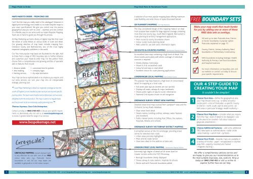
GREYSCALE MAPPING (sample displayed right)<br />
is very effective for use with one of our FREE<br />
colour data sets, e.g., Postcode Sector<br />
boundaries in red. All our map bases are<br />
available in greyscale or in full colour output.<br />
FREE BOUNDARY SETS<br />
Make your map work that much harder<br />
for you by adding one or more of these<br />
FREE data sets as overlays.<br />
Full and up to date Postcode Area, District<br />
or Sector boundaries. A popular option.<br />
Postcodes explained on page 10.<br />
County, District, Unitary Authority, Ward<br />
boundaries or Parlimentary Constituency.<br />
NHS boundaries including Strategic Health<br />
Authority & Primary Care Trust boundaries<br />
and hospital locations.<br />
For more information on boundary sets visit<br />
our website or contact us today to discuss<br />
your specific requirements.<br />
Telephone Bespoke Customer Services on 0843 2160 455 email: bespokes@mapmarketing.com www.bespokemaps.net Telephone Customer Services on 0843 2160 450 email: sales@mapmarketing.com www.mapmarketing.com<br />
▲<br />
▲<br />
▲<br />
▲<br />
▲<br />
▲<br />
A selection of our most popular mapping bases offering maximum<br />
scale flexibility and wide choice of styles (illustrated below).<br />
GB PLANNER’S MAPPING from <strong>Map</strong> <strong>Marketing</strong><br />
The crisp, uncluttered design of this mapping makes it an ideal<br />
multi-purpose base suitable for large regional coverage containing<br />
more than one county (e.g., South West England). Well suited to<br />
route planning & territory management applications.<br />
• Main routes & county boundaries shown<br />
• Colour-coded route planning detail<br />
• Well suited for use with extra information layers<br />
GB ROUTES & COUNTIES MAPPING – Bartholomew <strong>Map</strong>ping Solutions<br />
An excellent base map containing a high level of detail. This<br />
choice works particularly well where coverage of individual<br />
counties is required.<br />
• Clearly displays motorways<br />
• Shows A, B & unclassified roads<br />
• Colourful and easy to read detail<br />
• Excellent choice for route planning applications<br />
LANDRANGER LOCAL MAPPING from Ordnance Survey<br />
This popular map base features a high level of concentrated<br />
detail for mapping at a local scale.<br />
• Full street plan layouts (streets are not named)<br />
• Displays all roads, railways & major landmarks<br />
• Shows public rights of way & tourist information<br />
• National Grid squares shown to aid navigation<br />
ORDNANCE SURVEY STREET VIEW MAPPING<br />
Detailed street level map sourced from Landplan® data and the<br />
Ordnance Survey Roads database.<br />
• Clear street-level detail<br />
• Streets names, building outlines, railways, water features<br />
and woodland.<br />
• Public interest points including Post Offices, fire stations,<br />
hospitals, libraries and schools.<br />
ORDNANCE SURVEY VECTORMAP DISTRICT MAPPING<br />
A simplified version of the OS Landranger providing street<br />
names for selected main roads.<br />
• Urban areas precisely highlighted.<br />
• Main arterial roads named<br />
• Clear base ideal for the addition of data sets.<br />
LONDON STREET LEVEL MAPPING – Bartholomew <strong>Map</strong>ping Solutions<br />
Extremely high degree of detail at full street level for<br />
Greater London within the M25 Motorway.<br />
• Borough boundaries clearly displayed<br />
• Shows railway & tube stations, hospitals & schools<br />
• Works well with Postcode boundaries added<br />
1<br />
2<br />
3<br />
4<br />
✓<br />
✓<br />
✓<br />
✓<br />
OUR 4 STEP GUIDE TO<br />
CREATING YOUR MAP<br />
It couldn’t be simpler!<br />
Choose Your Area – define the geographical area<br />
your map should cover, e.g. • a radius around a<br />
centre point • a list of Postcodes • a specific County<br />
or District • north, south, east & west points • an<br />
NHS area or particular Strategic Health Authority •<br />
Choose Your <strong>Map</strong> Base – consider what you require<br />
from the map • level of detail to be displayed • size<br />
of the area to be covered • full colour output or<br />
greyscale presentation •<br />
Choose Additional Features – add some additional<br />
FREE data layers as outlined above • radial circles<br />
• area masking • custom text • symbols •<br />
Choose Your Finish – bespoke maps are available in<br />
a variety of finishes • paper • encapsulated in dry/wet<br />
wipe film • expertly mounted and framed<br />
• magnetic backing •<br />
We offer a complimentary advisory service and<br />
are happy to give you our recommendations as to<br />
the most suitable map base, size, scale etc. Ring us<br />
today on 0843 2160 455 or visit us online to<br />
explore further how we can help.<br />
8