
Create successful ePaper yourself
Turn your PDF publications into a flip-book with our unique Google optimized e-Paper software.
11<br />
Postcode Sector <strong>Map</strong>s and Products Postcode Sector <strong>Map</strong>s and Products<br />
POSTCODES<br />
HOW THEY ARE STRUCTURED<br />
Each Postcode (1.8 million in the UK) is a<br />
combination of between 5 and 7 numbers and<br />
letters representing 6 distinct levels of information<br />
presented in two halves. The first half, the<br />
Outward Code, represents one of 124 Postcode<br />
Areas in one of 2869 Districts. The second half<br />
of the Postcode, or the Inward Code, defines a<br />
Sector (nearly 9500) and a handful of<br />
addresses called Unit Postcodes.<br />
Take for example,the Postcode: SW18 1AZ<br />
OUTWARD INWARD<br />
S W 1 8 1 A Z<br />
Area District Sector Unit<br />
Level 1: Areas<br />
The country is segmented into 124 Areas which are<br />
denoted by the first two letters of the Postcode,<br />
e.g. SW<br />
Level 2: Districts<br />
Each Area is subdivided into Districts which are<br />
denoted by the number(s) in the first half of the<br />
Postcode (or Outward Code), e.g. SW18<br />
Level 3: Subdistricts<br />
This level of Postcode is a special division within<br />
the District Outward code and only occurs in<br />
certain densely populated location in London,<br />
For instance, the House of Commons’ Postcode<br />
is SW1A 0AA<br />
Level 4: Sectors<br />
Each District is further broken down into<br />
individual Sectors, which are denoted by<br />
the first number in the second part of the<br />
Postcode, e.g. SW18 1<br />
Level 5 & 6: Subsectors & Units<br />
These final two levels of the Postcode pinpoint<br />
a group of addresses, or even in some cases an<br />
individual business premises, e.g. SW18 1AZ<br />
POSTCODE PLANNING<br />
STARTER PACK<br />
Our laminated Postcode Areas<br />
<strong>Map</strong> and the Collins Postcode<br />
Atlas makeperfect companions<br />
for a variety of business<br />
planning application where<br />
Postcode are key. Select both<br />
of these products and pay only<br />
£77.50, that’s a saving of<br />
£19.49, over 20% off the<br />
individually priced items!<br />
Code PCPACK<br />
Price £77.50<br />
Telephone Customer Services on 0843 2160 450 email: sales@mapmarketing.com www.mapmarketing.com Telephone Customer Services on 0843 2160 450 email: sales@mapmarketing.com www.mapmarketing.com<br />
▲<br />
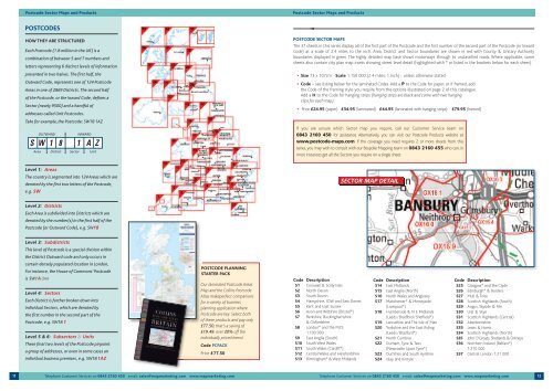
POSTCODE SECTOR MAPS<br />
The 37 sheets in this series display all of the first part of the Postcode and the first number of the second part of the Postcode (or Inward<br />
Code) at a scale of 2.4 miles to the inch. Area, District and Sector boundaries are shown in red with County & Unitary Authority<br />
boundaries displayed in green. The highly detailed map base shows motorways through to unclassified roads. Where applicable, some<br />
sheets also contain city plan map insets showing street level detail (highlighted with * or listed in the brackets below for each sheet).<br />
• Size 73 x 107cm Scale 1:150 000 (2.4 miles: 1 inch) - unless otherwise stated<br />
• Code – see listing below for the laminated Codes. Add a P to the Code for paper, or if framed, add<br />
the Code of the framing style you require from the options illustrated on page 2 of this catalogue.<br />
Add a H to the Code for hanging strips (hanging strips are black and come with two hanging<br />
clips for each map).<br />
• Price £24.95 (paper) £34.95 (laminated) £44.95 (laminated with hanging strips) £79.95 (framed)<br />
If you are unsure which Sector map you require, call our Customer Service team on<br />
0843 2160 450 for assistance. Alternatively, you can visit our Postcode Products website at<br />
www.postcode-maps.com If the coverage you need requires 2 or more sheets from this<br />
series, you may wish to consult with our Bespoke <strong>Map</strong>ping team on 0843 2160 455 who can, in<br />
most instances get all the Sectors you require on a single sheet.<br />
Code Description<br />
S1 Cornwall & Scilly Isles<br />
S2 North Devon<br />
S3 South Devon<br />
S4 Hampshire, IOW and East Dorset<br />
S5 Kent and East Sussex<br />
S6 Avon and Wiltshire (Bristol*)<br />
S7 Berkshire, Buckinghamshire<br />
& Oxfordshire<br />
S8 London* and the M25<br />
1:100 000<br />
S9 East Anglia (South)<br />
S10 South West Wales<br />
S11 South Wales (Cardiff*)<br />
S12 Central Wales and Herefordshire<br />
S13 Birmingham* & West Midlands<br />
SECTOR MAP DETAIL<br />
Code Description<br />
S14 East Midlands<br />
S15 East Anglia (North)<br />
S16 North Wales and Anglesey<br />
S17 Manchester* & Merseyside<br />
(Liverpool*)<br />
S18 Humberside & N E Midlands<br />
(Leeds /Bradford /Sheffield*)<br />
S19 Lancashire and The Isle of Man<br />
S20 Yorkshire and the East Riding<br />
(Leeds /Bradford*)<br />
S21 North Cumbria<br />
S22 Durham, Tyne & Tees<br />
(Newcastle Upon Tyne*)<br />
S23 Dumfries and South Ayrshire<br />
S24 Islay and Kintyre<br />
Code Description<br />
S25 Glasgow* and the Clyde<br />
S26 Edinburgh* & Borders<br />
S27 Mull & Tiree<br />
S28 Scottish Highlands (South)<br />
S29 Angus, Tayside & Fife<br />
S30 Uist & Skye<br />
S31 Scottish Highlands (Central)<br />
S32 Aberdeenshire<br />
S33 Lewis & Harris<br />
S34 Scottish Highlands (North)<br />
S35 John O’Groats, Shetlands & Orkneys<br />
S36 Northern Ireland (Belfast*)<br />
1:210 000<br />
S37 Central London 1:21 000<br />
12