NEH 16 Chapter 1 - NRCS Irrigation ToolBox Home Page
NEH 16 Chapter 1 - NRCS Irrigation ToolBox Home Page
NEH 16 Chapter 1 - NRCS Irrigation ToolBox Home Page

Create successful ePaper yourself
Turn your PDF publications into a flip-book with our unique Google optimized e-Paper software.
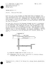
apidly permeable deposits may serve as channels for ground-water movement insome places at high rates of flow. A soil layer of low permeability overlyingsuch an aquifer may create a degree of confinement, which in turn develops anupward hydraulic gradient, particularly if the lower end of the aquifer is closedor of reduced permeability. Interception drains are effective where the aquiferis close enough to the surface so that it is feasible to cut off the flow.Relief wells or pumping may be used where interception is not practical.Subsurface soil masses of low permeability, such as clay lenses and offshoreclay bars formed in the geologic past, are local barriers to ground-water flow.They may cause the water table to be held to a high level and the flow to escapearound or over the barrier. Permeable layers that become thinner or graduallydecrease in permeability in a downstream direction have a similar effect on thewater table. Drains placed just upslope from the restriction usually are effectivein these situations. <strong>Irrigation</strong> canal seepage creates another kind oflateral ground-water flow problem. An intercepting drain at the toe of a canalbank or river levee may cut off much of the flow that would reach the wet areawhere a horizontal barrier forms a convenient "floor" for interception. However,the designer must consider the steeper hydraulic gradient such a drain causesand evaluate its effect on the canal-seepage loss and on the stability of theembankment against sloughing or piping. River seepage through or under leveescreates similar problems.These examples illustrate the unlimited variety of subsurface-drainage problems.The principles of interception, relief, or pumped-well drainage may be appliedto each according to the pattern of subsurface flow. The pattern of flow becomesknown from a field investigation of soil stratification, water source, and watertable or pressure data.Differences in Drainage in Humid and Arid AreasDrainage in humid areas has to do largely with excess water resulting from precipitation;in arid and semiarid areas, the need for drainage arises principallyfrom irrigation, with foreign ground water an important source in some areas.Surface-drainage systems may be required in either humid or in irrigated areas.Surface drainage ia usually an integral part of irrigation systems on slowlypermeable soils or in areas of high precipitation rates.The purpose of subsurface drainage is to lower the water table to a point whereit will not interfere with plant growth and development. The minimum depth atwhich the water level should be maintained varies according to both the croprequirement and the soil. One of the principal factors in the height of thewater table in arid areas is control of salinity and alkalinity in the soil andground water. This is a major reason for theadifference in the subsurfacedrainage of humid and of arid climates.The depth of drains in humid climates is generally 3 to 5 feet. Water isrelatively pure, there usually is a natural excess of water over plant requirements,and there is a net downward movement of ground water.Soils in semiarid or arid climates require subsurface drains at least 5 to 7 feetdeep. Most of the water needed by the crop is added by irrigation. Usuallyground water is somewhat saline because of salts in the soil, the irrigation water,or both. A water table as high as 24-30 inches below the surface, suitablein many humid areas, would create a harmful salt concentration in the root zonein arid areas.