GECDIS - Seatech
GECDIS - Seatech
GECDIS - Seatech
- No tags were found...

You also want an ePaper? Increase the reach of your titles
YUMPU automatically turns print PDFs into web optimized ePapers that Google loves.
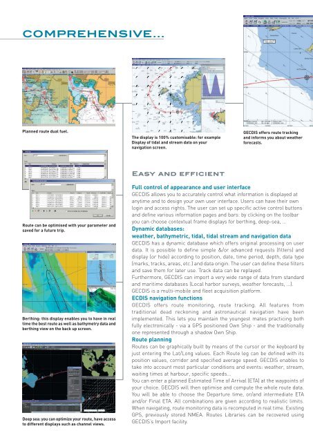
COMPREHENSIVE...Planned route dual fuel.The display is 100% customisable: for exampleDisplay of tidal and stream data on yournavigation screen.<strong>GECDIS</strong> offers route trackingand informs you about weatherforecasts.Easy and efficientRoute can be optimised with your parameter andsaved for a future trip.Berthing: this display enables you to have in realtime the best route as well as bathymetry data andberthing view on the back up screen.Deep sea: you can optimize your route, have accessto different displays such as channel views.Full control of appearance and user interface<strong>GECDIS</strong> allows you to accurately control what information is displayed atanytime and to design your own user interface. Users can have their ownlogin and access rights. The user can set up specific active control buttonsand define various information pages and bars: by clicking on the toolbaryou can choose contextual frame displays for berthing, deep-sea, …Dynamic databases:weather, bathymetric, tidal, tidal stream and navigation data<strong>GECDIS</strong> has a dynamic database which offers original processing on userdata. It is possible to define simple &/or advanced requests (filters) anddisplay (or hide) according to position, date, time period, depth, data type(marks, tracks, areas, etc.) and data origin. The user can define these filtersand save them for later use. Track data can be replayed.Furthermore, <strong>GECDIS</strong> can import a very wide range of data from standardand maritime databases (Local harbor surveys, weather forecasts, …).<strong>GECDIS</strong> is a multi-mobile and fleet acquisition platform.ECDIS navigation functions<strong>GECDIS</strong> offers route monitoring, route tracking. All features fromtraditional dead reckoning and astronautical navigation have beenimplemented. This lets you maintain the youngest mates practicing bothfully electronically - via a GPS positioned Own Ship - and the traditionallyone represented through a shadow Own Ship.Route planningRoutes can be graphically built by means of the cursor or the keyboard byjust entering the Lat/Long values. Each Route leg can be defined with itsposition values, corridor and specified average speed. <strong>GECDIS</strong> enables totake into account most particular conditions and events: weather, stream,waiting times at harbour, specific speeds...You can enter a planned Estimated Time of Arrival (ETA) at the waypoints ofyour choice. <strong>GECDIS</strong> will then optimise and compute the whole route data.You will be able to choose the Departure time, or/and intermediate ETAand/or Final ETA. All combinations are given according to realistic limits.When navigating, route monitoring data is recomputed in real time. ExistingGPS, previously stored NMEA. Routes Libraries can be recovered using<strong>GECDIS</strong>’s Import facility.