gis based pipeline route selection by arcgis in turkey - Gislab
gis based pipeline route selection by arcgis in turkey - Gislab
gis based pipeline route selection by arcgis in turkey - Gislab

You also want an ePaper? Increase the reach of your titles
YUMPU automatically turns print PDFs into web optimized ePapers that Google loves.
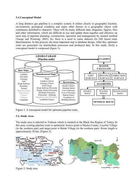
3.1.Conceptual ModelA long distance gas <strong>pipel<strong>in</strong>e</strong> is a complex system. It relates closely to geographic location,environment, geological condition and many other factors as a geographic object withcont<strong>in</strong>uous distributive character. There will be many different data, diagrams, figures, filesand other <strong>in</strong>formation, which are difficult to use and update them together and effective oneach step of <strong>pipel<strong>in</strong>e</strong> plann<strong>in</strong>g, construction, operation and management <strong>by</strong> manual method(Xaoge and Wentong, 2005). So, there is a need to raster datasets for GIS <strong>based</strong> <strong>route</strong>determ<strong>in</strong>ation. In this process, the most important step is database design. After this, optimum<strong>route</strong> are generated via <strong>in</strong>termediate processes and produced data. In this study, firstly aconceptual model is composed (figure 1).GEODATABASE(Pipel<strong>in</strong>e.mdb)CLASSIFYBase MapsRASTERCALCULATELanduseElevationGeologySoilRoad, RailwayBoundaryStreamSensitive AreasFlora/FaunaCultureTourismLandslideManufactured MapsSlopeLanduse ClassesGeology ClasessSoil ClassesRoad, Railway ProximityEnergy Source ProximityBoundary ProximityWatershed – HidrolgySensitive Areas ProximityLandslide ClassesRestrictionsRelative BarierAbsolute BarierCost CoherenceCost of ProximtyStation Po<strong>in</strong>tsAvoidance ofBuild<strong>in</strong>g DensityCOSTSURFACESOURCEPOINTDISTANCESURFACEALGORITHMSTATIONPOINTSOPTIMUM ROUTEDIRECTIONSURFACEDESTINATIONPOINTFigure 1. A conceptual model for optimum <strong>pipel<strong>in</strong>e</strong> <strong>route</strong>.3.2. Study AreaThe study area is selected <strong>in</strong> Trabzon which is situated <strong>in</strong> the Black Sea Region of Turkey Inthis area, exist<strong>in</strong>g <strong>pipel<strong>in</strong>e</strong> <strong>route</strong> is optimized. Source po<strong>in</strong>t is Macka County, Cayirlar Village(<strong>in</strong> the southern part) and target po<strong>in</strong>t is Bulak Village (<strong>in</strong> the northern part). Route length isapproximately 38 km. (Figure 2).Figure 2. Study area