gis based pipeline route selection by arcgis in turkey - Gislab
gis based pipeline route selection by arcgis in turkey - Gislab
gis based pipeline route selection by arcgis in turkey - Gislab

You also want an ePaper? Increase the reach of your titles
YUMPU automatically turns print PDFs into web optimized ePapers that Google loves.
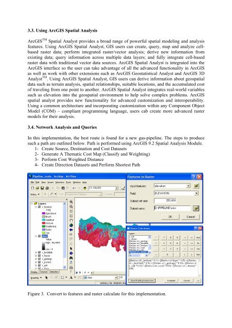
3.3. Us<strong>in</strong>g ArcGIS Spatial AnalysisArcGIS TM Spatial Analyst provides a broad range of powerful spatial model<strong>in</strong>g and analysisfeatures. Us<strong>in</strong>g ArcGIS Spatial Analyst, GIS users can create, query, map and analyze cell<strong>based</strong>raster data; perform <strong>in</strong>tegrated raster/vector analysis; derive new <strong>in</strong>formation fromexist<strong>in</strong>g data; query <strong>in</strong>formation across multiple data layers; and fully <strong>in</strong>tegrate cell-<strong>based</strong>raster data with traditional vector data sources. ArcGIS Spatial Analyst is <strong>in</strong>tegrated <strong>in</strong>to theArcGIS <strong>in</strong>terface so the user can take advantage of all the advanced functionality <strong>in</strong> ArcGISas well as work with other extensions such as ArcGIS Geostatistical Analyst and ArcGIS 3DAnalyst TM . Us<strong>in</strong>g ArcGIS Spatial Analyst, GIS users can derive <strong>in</strong>formation about geospatialdata such as terra<strong>in</strong> analysis, spatial relationships, suitable locations, and the accumulated costof travel<strong>in</strong>g from one po<strong>in</strong>t to another. ArcGIS Spatial Analyst <strong>in</strong>tegrates real-world variablessuch as elevation <strong>in</strong>to the geospatial environment to help solve complex problems. ArcGISspatial analyst provides new functionality for advanced customization and <strong>in</strong>teroperability.Us<strong>in</strong>g a common architecture and <strong>in</strong>corporat<strong>in</strong>g customization with<strong>in</strong> any Component ObjectModel (COM) – compliant programm<strong>in</strong>g language, users cab create more advanced rastermodels for their analysis.3.4. Network Analysis and QueriesIn this implementation, the best <strong>route</strong> is found for a new gas-<strong>pipel<strong>in</strong>e</strong>. The steps to producesuch a path are outl<strong>in</strong>ed below. Path is performed us<strong>in</strong>g ArcGIS 9.2 Spatial Analysis Module.1- Create Source, Dest<strong>in</strong>ation and Cost Datasets2- Generate A Thematic Cost Map (Classify and Weight<strong>in</strong>g)3- Perform Cost Weighted Distance4- Create Direction Datasets and Perform Shortest PathFigure 3. Convert to features and raster calculate for this implementation.