Thesis Template - UTM Format - FKE - UTM
Thesis Template - UTM Format - FKE - UTM
Thesis Template - UTM Format - FKE - UTM
- No tags were found...

You also want an ePaper? Increase the reach of your titles
YUMPU automatically turns print PDFs into web optimized ePapers that Google loves.
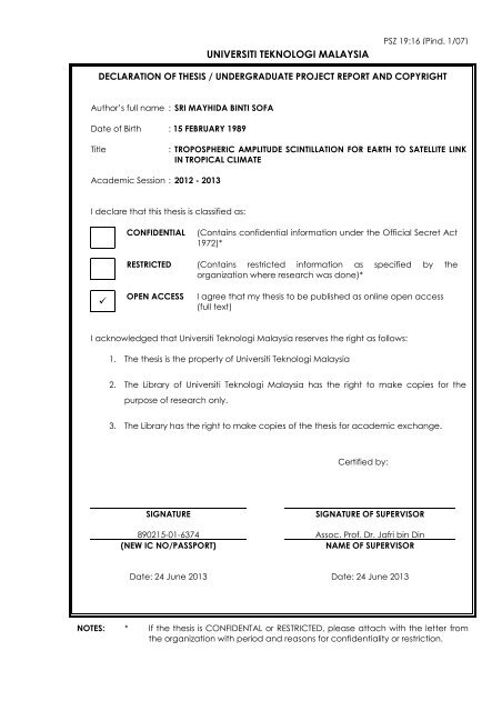
UNIVERSITI TEKNOLOGI MALAYSIAPSZ 19:16 (Pind. 1/07)DECLARATION OF THESIS / UNDERGRADUATE PROJECT REPORT AND COPYRIGHTAuthor’s full name : SRI MAYHIDA BINTI SOFADate of Birth : 15 FEBRUARY 1989Title: TROPOSPHERIC AMPLITUDE SCINTILLATION FOR EARTH TO SATELLITE LINKIN TROPICAL CLIMATEAcademic Session : 2012 - 2013I declare that this thesis is classified as:CONFIDENTIAL(Contains confidential information under the Official Secret Act1972)*RESTRICTED (Contains restricted information as specified by theorganization where research was done)*OPEN ACCESSI agree that my thesis to be published as online open access(full text)I acknowledged that Universiti Teknologi Malaysia reserves the right as follows:1. The thesis is the property of Universiti Teknologi Malaysia2. The Library of Universiti Teknologi Malaysia has the right to make copies for thepurpose of research only.3. The Library has the right to make copies of the thesis for academic exchange.Certified by:SIGNATURESIGNATURE OF SUPERVISOR890215-01-6374 Assoc. Prof. Dr. Jafri bin Din(NEW IC NO/PASSPORT)NAME OF SUPERVISORDate: 24 June 2013 Date: 24 June 2013NOTES: * If the thesis is CONFIDENTAL or RESTRICTED, please attach with the letter fromthe organization with period and reasons for confidentiality or restriction.
“I hereby declare that I have read this thesis and in myopinion this thesis is sufficient in terms of scope and quality for theaward of the degree of Bachelor of Electrical Engineering (Telecommunication)”Signature: ………………………….........Name of Supervisor : Assoc. Prof. Dr. Jafri bin DinDate : 24 June 2013
TROPOSPHERIC AMPLITUDE SCINTILLATION FOR EARTH TO SATELLITELINK IN TROPICAL CLIMATESRI MAYHIDA BINTI SOFAA thesis submitted in fulfilment of therequirements for the award of the degree ofBachelor of Electrical Engineering (Telecommunication)Faculty of Electrical EngineeringUniversiti Teknologi MalaysiaJUNE 2013
iiI declare that this thesis entitled “TROPOSPHERIC AMPLITUDE SCINTILLATIONFOR EARTH TO SATELLITE LINK IN TROPICAL CLIMATE” is the result of myown research except as cited in the references. The thesis has not been accepted forany degree and is not concurrently submitted in candidature of any other degree.Signature : ....................................................Name : Sri Mayhida binti SofaDate : 24 June 2013
iii[Specially dedicated to:my dear mother,my familyandmy late father]
ivACKNOWLEDGEMENTFirst and foremost thank, thanks to Allah S.W.T for blessing me with goodhealth and strength.I would like express the deepest appreciation to my supervisor, Assoc. Prof.Dr Jafri bin Din for his full support, encouragement and understanding throughoutmy study and project. His guidance and enthusiasm helps me a lot in completing thisproject.It gives me great pleasure in acknowledging the support and help of LamHong Yin for his co-operations, guidance and helps in this project.To my mother, Patonah binti Tokio, I cannot find word to express mygratitude for being my source of encouragement and inspiration to me throughout mylife. And my dear sister and brothers thank you for being very supportive to me.Thanks to my dear friends, Syuhadah, Puteri, Wizatul, Aida, Syuhana, Aqilahand Amalina who always helped me and believed that I could do it.And lastly, I would like to thank you to those who have assist me in thisresearch, directly or indirectly..
vABSTRACTTropospheric scintillation is a phenomenon where the amplitude or phase ofradio wave signal varies due to turbulence along the transmission path. It can besevere and under certain condition it will determine the practical limitation ofreliable communications at frequency above 10 GHz. Most of scintillation effectswere evaluated based on model for season climate. To determine the troposphericamplitude scintillation tropical climate, ITU-R Scintillation model were being used.This research was focused in communication link of Ku-band (12GHz) and Ka-band(19GHz). Two months of climate temperature and humidity data are used as theinput to determine the scintillation at Johor Bahru. Diurnal behavior of scintillationvariation also observed. Tropospheric scintillation amplitude was found to befrequency and local climate dependent.
viABSTRAKSintilasi troposfera adalah satu fenomena di mana amplitud atau fasa isyaratgelombang radio berbeza kerana pergolakan di sepanjang jalan penghantaran. Iaboleh menjadi serius dan di bawah keadaan tertentu ia akan menentukan hadpraktikal komunikasi dipercayai pada frekuensi melebihi 10 GHz. Kebanyakan kesansintilasi telah dinilai berdasarkan model untuk iklim musim. Untuk menentukansintilasi amplitud troposfera pada iklim tropika, model sintilasi ITU-R telahdigunakan. Kajian ini memberi tumpuan dalam pautan komunikasi Ku-band(12GHz) dan Ka-band (19GHz). Suhu dan kelembapan selama dua bulan digunakansebagai input untuk menentukan sintilasi di Johor Bahru. Tingkah laku harian variasisintilasi juga diperhatikan. Sintilasi amplitud troposfera didapati bergantung kepadafrekuensi dan iklim tempatan.
viiTABLE OF CONTENTSACKNOWLEDGEMENTivABSTRACTvABSTRAKviTABLE OF CONTENTSviiLIST OF TABLESixLIST OF FIGURESxLIST OF SYMBOLSxiGLOSSARY OF TERMSxiiLIST OF APPENDICESxiii1 INTRODUCTION 11.1 Project Background 11.2 Problem Statement 21.3 Objectives 31.4 <strong>Thesis</strong> Outline 42 LITERATURE REVIEW 52.1 Tropical Climate Characteristics 52.2 Atmospheric Effects on Signal Propagation 62.2.1 Atmospheric Absorption 62.2.2 Faraday Rotation 72.2.3 Cloud Attenuation 82.2.4 Ionospheric Scintillation 92.2.5 Rain Attenuation 102.2.6 Tropospheric Scintillation 112.3 Tropospheric Scintillation Prediction Model 112.3.1 Karasawa, Yamada and Allnutt Model 12
viii2.3.2 ITU-R Model 122.3.3 Van de Kamp Model 153 RESEARCH METHODOLOGY 163.1 General Work Flow for Tropospheric Amplitude Scintillationfor Earth to Satellite Link in Tropical Climate 163.2 Johor Bahru Meteorological Data Collection 173.3 Elevation Angle 183.4 MATLAB Programming for ITU-R ScintillationPrediction Model 194 RESULTS & DISCUSSION 234.1 Frequency Dependency of Scintillation 234.2 Diurnal Behavior of Scintillation 265 CONCLUSION AND FUTURE WORK 30REFERENCES 32A Matlab Programming For ITU-R Scintillation Model 34B Temperature Data in Johor Bahru 36C Humidity Data in Johor Bahru 38
ixLIST OF TABLESTABLE NO. TITLE PAGETable 3.1 Gantt Chart 22Table 4.1 Input Parameters for Scintillation Prediction 24
xLIST OF FIGURESFIGURE NO. TITLE PAGEFigure 2.1 Atmospheric Absorption 7Figure 2.2 Cloud Attenuation 8Figure 2.3 Ionospheric Scintillation 9Figure 2.4 Rain Attenuation 10Figure 3.1 <strong>UTM</strong> Weather Station 18Figure 3.2 MEASAT Website 19Figure 3.3 ITU-R Rec. 618 Scintillation Model MATLAB Programming 21Figure 4.1 Scintillation Fade Depth versus Time Percentage 25Figure 4.2 Diurnal variation for average temperature of October andNovember ’12 at four time interval 27Figure 4.3 Diurnal variation for average humidity of October andNovember’12 at four time interval 28Figure 4.4 Diurnal behaviour of scintillation of four different time interval 29
xiLIST OF SYMBOLSσDftHe sPN wet refLh LD effg(x)a(p)pA s ( p)Scintillation IntensityAntenna sizeAntenna efficiencyAntenna elevation angleOperating frequencyAverage local monthly temperatureAverage local humiditySaturation water vapour pressurePressureWet term of radio refractivityStandard deviation of the signal amplitude (reference)Effective path lengthHeight of the turbulent layerEffective antenna diameterAntenna averaging factorTime percentage factorTime percentageScintillation fade depth for the time percentage
xiiGLOSSARY OF TERMSITU-R - International Telecommunication Union (Radiocommunication)<strong>UTM</strong> - Universiti Teknologi MalaysiaMATLAB - Matrix LaboratoryMEASAT - Malaysia East Asia Satellite
xiiiLIST OF APPENDICESAPPENDIX TITLE PAGEA Matlab Programming For Itu-R Scintillation Model 34B Temperature Data In Johor Bahru 36C Humidity Data In Johor Bahru 38
CHAPTER 1INTRODUCTION1.1 Project BackgroundAs one essential element in telecommunication system, satellitecommunication provides many features that are not afford by other communicationsystems[1]. High bandwidth and data rates are the most important advantages ofsatellite communication. However, there are several transmission impairments thatcan be as the factor of signal degradation. One of them is due to atmospheric effectwhich it will give huge impact in satellite communication link and troposphericscintillation is yet another among of these atmospheric effects.Troposphere is the lowest layer of atmosphere in which it is closest to theearth ground. As the ground surface heats up, boundary layer of atmosphere exciteswhich it causing refractive index to be varied slightly generates as the atmosphereturbulent. When wave travels through this turbulent mixing atmosphere, it willexperience alternation and scattering which received and called as scintillation.Scintillation is generally will be happened in all region of atmosphere. But it issignificant at troposphere layer with the communication link at the frequency above
210 GHz. So by definition, tropospheric scintillation is a phenomenon of rapid signalfluctuation that occurred due to small scale variation in refractive index attroposphere layer [1].There several models that can be applied to calculate the amplitude oftropospheric scintillation in such as Karasawa, Yamada and Allnutt model, ITU-Rmodel, and Van de Kamp model. Hence, most of those models that available arevalidated but some of them may not relevant for tropical climate country.Additionally, scintillation also changes diurnally. Therefore, this study must be doneto analysis the amplitude scintillation in tropical region. This research will alsopresent the effect of diurnal variation on tropospheric scintillation.1.2 Problem StatementTropospheric scintillation can be categorized under one of the transmissionimpairment. Admitting the affects is only a short time fluctuating signal, but it cangive severe signal degradation on satellite-earth link that operates at 10 GHz andabove. Most of the scintillation prediction model was implemented based on fourseason countries climate. Tropical climate was known as uniform temperature, highhumidity and heavy rain characteristics in which so different with four seasonsclimate. Scintillation will occurred no matter the in clear sky condition or raining[2]. So, this proposed work aimed to evaluate the performance of troposphericamplitude scintillation in tropical region at clear sky condition.
31.3 ObjectivesThe study is mainly focused on the tropospheric amplitude scintillation effectbased on tropical climate. To be specific, the objectives of this study are as follows:1. To estimate the statistic of scintillation at Johor Bahru based on the parameters inITU-R model.2. To observe the relationship between the scintillation intensity and the localenvironmental parameters.3. To investigate diurnal variation impact on scintillation intensity.1.4 Scope of ProjectThis research are targeting on revision on the clear sky scintillation effect inthe equatorial region (Peninsular Malaysia). Besides, investigation of scintillationeffect will focused on the K u -band (12GHz) and K a -band (19GHz) frequency. Apartfrom that, finding of tropospheric scintillation amplitude effect will be demonstratedon the satellite communication performance in Peninsular Malaysia. In addition,diurnal variation of tropospheric scintillation effect will be assessed based on thelocal meteorological which are temperature and humidity. Validation will be doneusing data form Malaysia Meteorological Data.
41.4 <strong>Thesis</strong> OnlineThis thesis mainly consists 5 chapters. In first, brief introduction aboutscintillation, objectives and scope of the project are given. In chapter 2, theory andliterature review will be presented. It well discuss on a few scintillation modelavailable. Later, the project flow and methodology that have been used will beelaborated in Chapter 3. On the next chapter, detail discussion on the result anddiscussion that have been achieved. Chapter 5 will do the summary on this project.
CHAPTER 2LITERATURE REVIEWThis chapter presents revision on tropical climate characteristics focusing toMalaysia’s climate. Next, study was done on atmospheric effects phenomena that canlead to signal loss on transmission through the earth’s atmosphere. Since this project ismainly involving tropospheric scintillation, a review done on tropospheric layerformation. Furthermore, three models that mainly used for scintillation prediction asmentioned in Chapter 1 were reviewed. For this research, ITU-R model was decided tobe used as it have been developed based on Karasawa, Yamada and Allnutt model andVan de Kamp model.2.1 Tropical Climate CharacteristicsTropical climate region have been defined as those having uniform averageannual temperature. In addition of having uniform temperature throughout the year,
6tropical climate region does not experience winter at all which the terms of winter andsummer essentially have no meaning[3]. Malaysia's climate is categorized as equatorial,being hot and humid throughout the year because of its location near the equator. So, thecharacteristic features of the climate of Malaysia are uniform temperature, high humidityand copious rainfall[4].2.2 Atmospheric Effects on Signal PropagationThe earth’s atmosphere effect on radiowaves propagation between earth andspace is always the concern in the design and performance of satellite communicationssystems. This effect can cause unrestrained variations in signal amplitude, phase,polarization, and angle of arrival, resulting as a degradation of the analogue transmissionquality and an escalation in the error rate of digital transmissions. Spacecommunications are influenced by on the local climate, operating link frequency, type oftransmission, and elevation angle to the satellite. Such unpredictable and naturephenomenon will give effect on transmission impairments on satellite communications.2.2.1 Atmospheric AbsorptionAtmospheric absorption occurred when electromagnetic waves interact withmolecules in the atmosphere caused signal attenuation[5]. These molecules will absorbsome parts of the signal and the remaining will be scattered, refracted or reflected. Thereare various different molecules and particles contained in the atmosphere that absorbs
7and transmits many electromagnetic radiations with different wavelengths. Watervapour, carbon dioxide and ozone cause most of the absorption.Figure 2.1: Atmospheric Absorption[6]2.2.2 Faraday RotationFaraday effect is one of the ionospheric effect which the waves that leaves theionosphere has a different polarization. Due to interaction of electromagnetic wave withEarth’s magnetic field, the plane of polarization of the wave is rotated when anelectromagnetic wave that passes through a region with high electron density[7]. Theplane of polarization rotation is proportional to the total electron density in the ionizedarea. Solar activity, incident wave direction, state of the ionosphere and time of the daywill also determine the rotation direction. Besides, the rotation will be contrary fortransmitted and received signal.
82.2.3 Cloud AttenuationThe influence of clouds can also be existed on an earth-space path and must alsobe taken into account. Clouds are composed of either water droplets or ice crystals. Iceclouds, by feature of the low dielectric constant of ice and the small size of the essentialparticles, are expected not to cause considerable attenuation to radiowaves in thefrequency range below 50 GHz[8]. Attenuation by clouds also be determined by thetemperature of the droplets[9].Figure 2.2: Cloud Attenuation
92.2.4 Ionospheric ScintillationIonospheric scintillation is usually observed as irregular transient variation in thereceived signal strength and arises from spatial and temporal fluctuations in theionosphere’s electrical characteristics. Irregularities in small scale refractive indexcaused by local ion concentration will yields scintillation in ionosphere.This amplitude scintillation assumes to be accompanied by fluctuation in phaseand apparent angle of arrival [10]. While summer months during intense solar activity atequatorial region ionospheric scintillation will occur. Ionospheric scintillation seems tobe inversely proportional to frequency rising. In other word, ionospheric scintillationwill be decreased due to increasing of the operating link frequency. Concentration oflocal ion produces discontinuities and cause refraction. As the consequence, two signalswill be reaching the receiving antenna which is direct path and the refracted path as inFigure 2.3.Figure 2.3: Ionospheric Scintillation
102.2.5 Rain AttenuationAs the major weather effect, rain along the transmission path factor must betaken into consideration in concern for earth-space communications operating in thefrequency bands above 3 GHz. The rain problem is particularly important forcommunication link above 10 GHz. Raindrops will be a medium that absorb and scatterradiowave signal, which resulting as reduction in the transmitted signal amplitude. Thiscondition called as rain attenuation can reduce the dependability and performance of thecommunications link.Figure 2.4: Rain Attenuation[11]
112.2.6 Tropospheric Scintillation PhenomenonWarming up process of earth surface cause the excitement of tropospherelayer[12]. This condition will induce turbulence into the layer. The turbulence is randomfluctuations in the refractive index along path of signal transmission will contributeincrease to rapid variations in the received radio signal amplitude. The effect of signaldegrading is known as scintillation. It is seasonally dependent, and varies day to daywith the local climate.Tropospheric scintillation is practically usually exist to varying degrees on anyearth-space link, but at high frequencies (>10 GHz) or low elevation angles the level ofscintillation fade may be significant and therefore have need of being taken into accountin the communication system’s link budget [13]. Thus, signal level fluctuations owing toscintillation must be understood for the purpose of correct design of satellite.2.3 Tropospheric Scintillation Prediction ModelSatellite communication system that operates above 10 GHz with low marginand low elevation angle are vulnerable to tropospheric scintillation. The prediction andmodeling of tropospheric scintillation come to be important for such systems Forexample, a low weather margin system (< 3 to 4 dB) with a low elevation angle (e.g.,below about 10.) may experience more degradation from scintillation than from rain.Scintillation models needed to be accurate in order to designing these types of systems.Karasawa and the ITU-R model that will be presented in Sections 2.3.1 and 2.3.2 areonly considering the clear sky scintillation [13]. While scintillation can also occur due to
12rain Van de Kamp developed a model as the extension for the Karasawa model whichthe effects of cloud scintillation included.2.3.1 Karasawa, Yamada and Allnutt ModelThe model development was done at Yamaguchi, Japan in 1988, at elevationangle of 6.5˚ with frequency of 11.5 and 14.23 GHz and diameter of antenna is 7.6m. Toevaluate scintillation, the parameter needed are the predicted signal standard deviation(scintillation intensity), frequency, apparent elevation angle, antenna averaging,effective antenna diameter, geometrical antenna diameter and antenna apertureefficiency[14]. The advantage of this model is that it fixed the flaw of other models butonly applied to four season countries[14].2.4 ITU-R ModelITU-R model makes scintillation statistics easier to be estimated. It has beenproposed for frequency range of 7-14GHz[15]. In the presence of this model, statistic ofscintillation can be estimated from the local environmental parameters.ITU-R model determine the parameter σ, the standard deviation of theinstantaneous signal amplitude (amplitude expressed in dB)[16]. The parameter σreferred as scintillation intensity. The parameters that taken into account are as follows:
131. Antenna size, D and efficiency, 2. Antenna elevation angle, 3. Operating frequency, f4. Average local monthly temperature, t5. Average local monthly relative humidity,Follows are mathematical model of ITU-R model that can be used to get the scintillationintensity:Step 1: Calculate the saturation water vapour pressure, e s , (hPa) [17]e s tb td EF aexp t c EF water4721107.2 P 0.00320 5.9 10t472EF ice 1102.2 P0.003826.410t(2.1)(2.2)(2.3)where:for waterfor icea 6.1121 a 6.1115b 18.678 b 23.036c 257.14 c 279.82d = 234.5 d = 333.7(valid between –40 to 50 (valid between –80 to 0Step 2: Compute the wet term of the radio refractivity, N wet , [15](2.4)Step 3: Calculate the standard deviation of the signal amplitude, ref , used as reference: 3.6 10 10–3 – 4refN wetdB(2.5)
14Step 4: Calculate the effective path length L according to:L sin2 2h L2.35 10–4sinm(2.6)where h L is the height of the turbulent layer; the value to be used is h L 1 000 m.Step 5: Estimate the effective antenna diameter, D eff , from the geometrical diameter, D,and the antenna efficiency :D eff Dm(2.7)Step 6: Calculate the antenna averaging factor from:2 11/12 111g( x) 3.86 ( x 1) sinarctan 7.08 x 6 x5/6(2.8)with:2x 1.22 Deff( f/ L)(2.9)where f is the carrier frequency (GHz).If the argument of the square root is negative (i.e. when x > 7.0), the predictedscintillation fade depth for any time percentage is zero and the following steps are notrequired.Step 7: Calculate the standard deviation of the signal for the considered period andpropagation path: reff7/12g(x)(sin )1.2(2.10)
15Step 8: Calculate the time percentage factor, a( p), for the time percentage, p, ofconcern in the range 0.01 p 50:a( p) –0.061 (log 10 p) 3 0.072 (log 10 p) 2 – 1.71 log 10 p 3.0 (2.11)Step 9: Calculate the scintillation fade depth for the time percentage p by:A s ( p) a( p) · dB (2.12)But, this model fails to predict the dependence of scintillation on temperature ina dry atmosphere when is insignificant[18].2.5 Van de Kamp ModelThe model development was done at four different places which are Finland,United Kingdom, Japan, and Texas. For both Karasawa and ITU-R model, scintillationwas measured based on only monthly average of wet part of refractivity N wet at groundlevel [19]. So, Van de Kamp model proposed to extend Karasawa and ITU-R modelwhich cloud scintillation also taken into consideration[19]. In addition, diurnal variationin scintillation was also introduced in this model. With diurnal variation, we can see thateffect of scintillation is different at morning, midday, evening and night. [2]
CHAPTER 3RESEARCH METHODOLOGYFor this chapter, the procedure and flow of the project will be presented. Reviewon procedure is as follows. First is revision on tropospheric scintillation theories.Second, review on scintillation model prediction. Third, process the local meteorologicaldata from <strong>UTM</strong> Weather Station. Forth is simulating the mathematical model ofscintillation prediction using MATLAB based on local meteorological data. Next,analyze the scintillation statistics from the prediction model. And last, repeat thesimulation, analysis and comparison for diurnal variation.3.1 General Work Flow for Tropospheric Amplitude Scintillation for Earth toSatellite Link in Tropical ClimateGenerally, this project divided into two parts which is first focus intotropospheric scintillation theories, prediction models and data processing. Second is
17simulation and result analysis. The theories revision was done on the phenomenon ofscintillation. While looking over the tropospheric scintillation phenomenon, review ontropical climate also has been done. Furthermore, study on earth to communication linkalso done.Subsequently, the meteorological data from local site were collected. The localmeteorological data were obtained from <strong>UTM</strong> Weather Station and MalaysiaMeteorological Department. The meteorological data that has been collected are localtemperature and local humidity at Johor Baharu. These two months of raw data wereprocessed into average to enable it to be used in MATLAB simulation. For diurnalvariation, the data were being averaged into 4 time slots.After data processing was accomplished, scintillation intensity was determinedwith MATLAB simulation using local meteorological from <strong>UTM</strong> Weather Station.3.2 Johor Bahru Meteorological Data CollectionTwo months of meteorological data at Johor Bahru on October and November’12 were gathered from <strong>UTM</strong> Weather Station located at P18, Faculty of ElectricalEngineering <strong>UTM</strong>. As one of the project objectives is observe the relationship betweenthe scintillation intensity and the local environmental parameters, the data on localtemperature and humidity were processed. As the raw data were taken by minute, dataprocessing is necessary in order to make it as input parameter for MATLAB simulation.For studies on diurnal variation, the data were processed into four different time intervalto see the effect of temperature and humidity to the scintillation intensity.
18Figure 3.1: <strong>UTM</strong> Weather Station3.3 Elevation AngleElevation angle is another important parameter for the scintillation prediction.The value of the elevation angle was determined from MEASAT website.
19Figure 3.2: MEASAT Website3.4 MATLAB Programming for ITU-R Scintillation Prediction ModelFor the simulation on the scintillation, MATLAB programming was used.MATLAB is a high-level language and interactive environment for numericalcomputation, visualization, and programming. Using MATLAB analyzes data, developalgorithms, and create models and applications can be done. The language, tools, andbuilt-in math functions enable the user to explore multiple approaches and reach asolution faster than with spreadsheets or traditional programming languages, such asC/C++ or Java.
20MATLAB code was developed based on the ITU-R Rec. 618. The M-files willreturns the scintillation fade depth exceeded for different probability levels according tothe ITU-R Rec. 618 for an earth-space link where the procedure is adapted for elevationover 4 degrees.ITU-R Scintillation Model were choose to be used in this project because it is aquick and effective method to estimate the statistics of tropospheric amplitudescintillation ITU-R Scintillation Model able to provide general technique for predictingthe cumulative distribution of tropospheric scintillation at elevation angles greater than4° which the elevation angle of this location of interest is 75.61˚. Furthermore, thismodel involves the scintillation calculation based on monthly or longer averages oftemperature and relative humidity, and reflects the specific climatic conditions of thesite.Figure 3.3 shows the programming lines based on ITU-R Rec. 618. The coding isgenerally consists the formulas to get scintillation fade depth. The output will be a graphthat indicated the scintillation reading in dB.
Figure 3.3: ITU-R Rec. 618 Scintillation Model MATLAB Programming21
22Table 3.1: Gantt ChartNoActivities/MonthsSep-12 Oct-12 Nov-12 Dec-12 Jan-13 Feb-13 Mar-13 Apr-13 May-13 Jun-131 2 3 1 2 3 4 1 2 3 4 1 2 3 4 1 2 3 4 1 2 3 4 1 2 3 4 1 2 3 4 1 2 3 4 1 2 3 41Revision on tropospheric scintillationReview on scintillation model2 Processing Meteorological Data3 Matlab Programming4 Simulation using Meteorological Data5 Results Analysis6 <strong>Thesis</strong> Writing7 Marks and Evaluation8 End of FYP
CHAPTER 4RESULT & DISCUSSIONPrevious chapter was about the research methodology for completing theproject. This chapter will be presenting the result of the project on the effect ofscintillation based on input parameters in ITU-R Scintillation Model. Heredependency of scintillation on the frequency and local meteorological parameter willbe seen.4.1 Frequency Dependency of ScintillationBased on the project objectives, one of them is to estimate the scintillationintensity based on the input parameter in the ITU-R scintillation. So, the researchfocused on measuring scintillation at Johor Bahru.
24Table 4.1 represent the input parameters that will be used to determine theamplitude scintillation. The frequency parameters are 12 GHz which is K u band and19GHz which is K a band. While the meteorological parameter is the mean for 2months weather data.The scintillation intensity will increase with frequency. This is proven withthe simulation. As illustrated on Figure 4.1, scintillation static was estimated at 4.02dB for K a band is higher in value than scintillation intensity for K u band which is3.124 dB. Since the effect of scintillation is strongly frequency dependent, signalwith shorter wavelength will encounter more severe variation. It can be said that K aband communication link are more affected by scintillation phenomenon than K uband communication link.Table 4.1: Input Parameters for Scintillation PredictionSatelliteMeasat 3 DownlinkSiteJohor BahruLongitude 103.64 °ELatitude 1.56 °NElevation angle 75.61°[20]Frequency 12GHz, 19GHzAntenna 2.4mTemperature 26.85°CHumidity 86.88%
Figure 4.1: Scintillation Fade Depth versus Time Percentage25
264.2 Diurnal Behavior of ScintillationScintillation is strongly dependent on temperature and humidity. Hightemperature and humidity give the highest scintillation amplitude for a given path.As a significance of this dependence, scintillation is expected to exhibit diurnalpatterns of variations.Temperature and humidity are interrelated to each other. Temperature willincrease when the day heading towards midday (noon) and starts to drop after theafternoon. Contrarily, humidity starts to fall when the day moving toward middayand began to increase after the afternoon. Temperature is at the highest point and thelowest humidity when it is midday. Figure 4.2 and 4.3 illustrates the relationshipbetween temperature and humidity corresponds to four different time slots.Figure 4.4 shows that scintillation intensity is highest when it is midday.inregards to maximum average temperature and lowest humidity for October 2012 andNovember 2012. Difference of scintillation intensity between the time slots is notobvious due to nearly uniform of local temperature and humidity. Increasing oftemperature will cause rising in scintillation intensity. The variation ofmeteorological parameters can contribute to scintillation because its influence on wetterm of refractivity index[21]. These variations cause the refractive index of the air introposphere layer to fluctuate from one point to the other. It can be seen in ITU-Rmodel, temperature and humidity is the function of wet term of refractivity index. Asconclusion, meteorological parameter influence tropospheric amplitude scintillation.
Figure 4.2: Diurnal variation for average temperature of October and November ’12 at four time interval.27
Figure 4.3: Diurnal variation for average humidity of October and November’12 at four time interval.28
Figure 4.4: Diurnal behaviour of scintillation of four different time interval.29
CHAPTER 5CONCLUSION AND FUTURE WORKTroposphere layer is lowest part in atmospheric layer. Fluctuations of weatherparameters like temperature and relative humidity primarily at the lower part of theearth called the troposphere will form irregularities in the refractivity index whichcaused the tropospheric scintillation phenomenon. Even scintillation is only shorttime fluctuating signal, it can give severe signal degradation on satellite-earth linkthat operates at 10GHz and above.Most of scintillation model were developed based on four season countriesclimate but lack for tropical climate. Thus, for this project the scintillation statisticswere determined based on tropical climate region meteorological data. In order toobtain the result, two months meteorological data of Johor Bahru were processed tobe as input parameter for ITU-R Scintillation Prediction Model. The effect of linkfrequency on scintillation also observed. The frequency effect was determined basedon K u band K a band communication. Other than that, the diurnal behaviour ofscintillation was also investigated.
31In regards to the objective of project, scintillation intensity was found to befrequency dependent. Apart from that, local temperature and humidity also affectedthe scintillation intensity. While for diurnal behaviour, the scintillation statistics wasat the highest level at midday (noon) time range.For future work, investigation on scintillation at different location of interestwould be proposed. This is to validate the scintillation based on various locations intropical climate not only in Johor Bahru. In addition, study on the effect of cloud onscintillation would also recommended in which current study is only consideringclear sky scintillation.
REFERENCES[1] L. J. Ippolito, Satellite communications systems engineering: atmosphericeffects, satellite link design and system performance: Wiley, 2008.[2] N. Binti Abdul Rahim, M. R. Islam, S. O. Bashir, J. Mandeep, and H. Dao,"Analysis of long term tropospheric scintillation from Ku-band satellite linkin tropical climate," in Computer and Communication Engineering (ICCCE),2012 International Conference on, 2012, pp. 690-693.[3] J. E. Oliver, The Encyclopedia of World Climatology: Springer-Verlag, 2005.[4] (September 2011). Malaysia Meteorology Department. Available:www.met.gov.my[5] K. Saha, The Earth's Atmosphere: Its Physics and Dynamics: SpringerLondon, Limited, 2008.[6] (2000). Available: http://www.everythingweather.com/atmosphericradiation/absorption.shtml[7] A. K. Maini and V. Agrawal, Satellite Technology: Principles andApplications: Wiley, 2011.[8] J. S. Mandeep and S. I. S. Hassan, "Cloud Attenuation for SatelliteApplications Over Equatorial Climate," Antennas and Wireless PropagationLetters, IEEE, vol. 7, pp. 152-154, 2008.[9] L. L. Fu and A. Cazenave, Satellite Altimetry and Earth Sciences: AHandbook of Techniques and Applications: Elsevier Science, 2000.[10] T. Iida, Satellite Communications: System and Its Design Technology:Ohmsha, Limited, 2000.[11] M. S. a. B. Bianchi. Rainfall estimation using microwave links. Available:http://lte.epfl.ch/page-50160-en.html[12] R. J. Hill, R. A. Bohlander, S. F. Clifford, R. W. McMillan, J. T. Priestly, andW. P. Schoenfeld, "Turbulence-induced millimeter-wave scintillationcompared with micrometeorological measurements," Geoscience and RemoteSensing, IEEE Transactions on, vol. 26, pp. 330-342, 1988.[13] F. S. Marzano and G. D'Auria, "Model-based prediction of amplitudescintillation variance due to clear-air tropospheric turbulence on Earth-
33satellite microwave links," Antennas and Propagation, IEEE Transactionson, vol. 46, pp. 1506-1518, 1998.[14] Y. Karasawa, M. Yamada, and J. E. Allnutt, "A new prediction method fortropospheric scintillation on Earth-space paths," Antennas and Propagation,IEEE Transactions on, vol. 36, pp. 1608-1614, 1988.[15] "Recommendation ITU-R P.618-10," in Propagation data and predictionmethods required for the design of Earth-space telecommunication systems,ed, 2010.[16] U. S. N. Aeronautics, S. A. O. o. Space, and T. Applications, PropagationEffects Handbook for Satellite Systems Design - a Summary of PropagationImpairments on 10-100 GHz Satellite Links, with Techniques for SystemDesign, 1980.[17] "Recommendation ITU-R P.453-10," in The radio refractive index: itsformula and refractivity data, ed, 2012.[18] N. B. A. Rahim, H. Dao, M. R. Islam, and A. F. I. Ibrahim, "Prediction of thetropospheric scintillation for earth to satellite link in tropical climate," inMechatronics (ICOM), 2011 4th International Conference On, 2011, pp. 1-6.[19] J. K. Tervonen, M. M. J. L. van de Kamp, and E. T. Salonen, "Predictionmodel for the diurnal behavior of the tropospheric scintillation variance,"Antennas and Propagation, IEEE Transactions on, vol. 46, pp. 1372-1378,1998.[20] http://www.measat.com/support_customer_azimuth.html.[21] B. C. Isikwue, Kwen, Y. A.1 and Chamegh, T.M1 and . "Variations in theTropospheric Surface Refractivity over Makurdi, Nigeria," Global ResearchJournals vol. Vol.3(2), 26th March 2013 2013.
AAPPENDIX AMATLAB PROGRAMMING FOR ITU-R SCINTILLATION MODELif nargin==5,eta=0.65;endu%%% if elev > 4.*pi/180,if elev
35if ~isempty(I),std_sc(I)=sig.*(-0.061.*(plog(I).^3)+0.072.*(plog(I).^2)-1.71.*plog(I)+3);end%%% endreturn
36BAPPENDIX BTEMPERATURE DATA IN JOHOR BAHRUDate 0000 - 0600 0600 - 1200 1200 - 1800 1800 - 2400Min Max Mean Min Max Mean Min Max Mean Min Max Mean01/10 22.97 23.62 23.36 23.16 33.16 27.86 30.95 35.08 33.35 25.96 30.95 27.6302/10 24.82 26.21 25.5 25.11 33.6 28.3 29.79 34.76 31.31 25.02 29.72 26.8703/10 24.05 25.28 24.48 23.88 33.21 28.4 30.75 35 33.02 26.45 30.87 28.1504/10 24.9 26.65 25.8 24.8 31.97 28.16 30.12 34.2 31.83 26.99 30.27 28.1805/10 25.31 27.19 26.3 25.36 31.54 28.19 27.04 30.6 29.45 25.79 29.34 27.0606/10 23.76 26.26 24.51 23.86 32.98 28.27 29.19 33.31 30.7 25.28 29.22 26.8907/10 24.39 25.43 24.91 24.07 32.64 27.89 29.94 33.63 31.5 25.45 30.04 27.2208/10 23.86 25.7 24.74 23.71 31.82 28.03 30.42 34.02 32.11 26.11 31.51 28.0609/10 24.65 26.28 25.43 24.77 33.81 28.49 22.47 32.9 25.43 23.79 24.7 24.2110/10 23.06 24 23.4 23.18 33.13 27.27 23.57 33.55 27.95 23.74 25.45 24.3711/10 23.64 24.99 24.28 23.67 31.1 27.1 23.62 33.37 28.19 23.91 25.28 24.5612/10 23.79 24.7 24.13 23.76 31.03 26.63 25.79 33.13 30.23 25.36 26.55 2613/10 24.58 26.28 25.32 24.03 31.74 27.34 22.56 32.48 25.54 23.71 24.51 24.1114/10 23.26 24.29 23.76 23.16 32.74 27.3 24.1 33.68 28.05 24.29 25.53 24.6715/10 23.74 24.51 23.99 23.86 30.75 26.48 23.69 33.03 30.41 23.79 24.7 24.3816/10 23.79 24.68 24.21 23.76 32.02 27.32 28.17 32.79 30.57 24.92 28.12 26.0917/10 23.59 24.99 24.18 23.59 32.02 26.83 23.35 33.42 28.29 23.52 24.58 24.0418/10 23.26 24.17 23.49 23.26 30.32 26.52 24.48 31.82 27.09 24.24 25.84 24.9819/10 23.64 24.48 24.04 23.52 31.13 26.85 24.56 27.46 25.14 24.07 24.9 24.420/10 23.14 24.56 23.7 23.86 30.47 25.85 25.11 33.39 30.91 24.63 25.48 24.9621/10 23.95 25.07 24.47 23.93 30.95 26.98 23.83 29.37 26.51 24.73 27.33 25.6322/10 24.17 25.19 24.48 23.98 31.03 26.66 27.14 31.84 30.23 25.33 29.54 26.4323/10 24.1 25.38 24.67 24.1 31.56 27.16 30.82 34.26 32.52 25.87 31.26 27.7924/10 24.29 25.91 25.13 24.36 32.41 28.12 29.07 35.13 32.39 26.57 30.42 27.9225/10 24.27 26.62 25.49 24.22 32.74 28.39 28.05 34.89 31.37 25.96 28.22 26.8226/10 25.23 25.99 25.78 25.84 31.94 28.53 30.52 34.36 32.34 25.99 30.5 27.9427/10 25.16 26.72 25.85 24.8 31.84 27.98 30.6 33.63 32.07 25.89 30.5 27.5328/10 24.36 26.33 25.19 24 32.2 28.21 29.87 34.12 32.56 25.62 25.82 27.5229/10 24.56 26.06 25.29 24.24 32.3 28.15 29.44 33.44 31.67 26.28 29.46 27.5130/10 24.61 26.4 25.31 24.56 30.37 27.05 24.68 30.42 28.87 25.77 28.92 26.8831/10 25.09 26.01 25.62 24.7 31.13 27.94 24.53 31.2 26.48 24.12 25.23 24.7401/11 23.69 24.17 23.95 23.52 30.72 26.61 24.75 31.03 27 24.12 24.87 24.3702/11 23.3 24.61 24.05 32.05 32.05 27.14 23.79 33.37 30.64 23.67 24.58 24.2603/11 23.95 25.02 24.46 23.83 30.52 26.06 23.14 31.84 27.93 23.16 23.81 23.4204/11 23.26 23.81 23.48 23.35 30.07 26.47 23.21 32.54 28.21 23.64 24.22 23.9905/11 24.05 24.32 24.17 22.39 27.7 24.56 27.7 31.26 29.21 25.77 27.85 26.5106/11 24.63 25.84 25.03 24.51 30.77 26.93 24.85 32.38 28.31 24.63 25.67 25.0907/11 24.58 25.74 25.17 24.87 31.36 27.61 28.79 32.9 30.65 26.06 28.74 26.8208/11 24.75 26.4 25.57 24.51 31.97 27.83 23.62 34.05 29.2 23.5 24.61 24.07
3709/11 24.05 25.4 24.83 25.07 31.61 27.48 27.31 32.74 30.11 25.31 27.6 25.9810/11 24.1 25.4 24.66 24.03 32.54 27.69 24.58 34.05 28.19 25.04 26.13 25.4411/11 24.77 25.67 25.06 24.94 32.05 27.81 28.12 34.52 31.63 25.87 28.05 26.4912/11 25.23 26.06 25.58 25.48 30.62 27.59 23.35 31.43 28.49 23.28 24.46 23.9913/11 24.1 24.51 24.32 23.76 31.1 26.9 23.47 31.66 27.15 24.39 25.16 24.6314/11 24.29 24.51 24.4 24.12 30.02 26.63 24.51 33.99 29.01 24.51 25.07 24.815/11 24.24 25.48 24.7 24.36 30.62 26.91 27.75 31.43 29.58 25.57 29.34 27.1416/11 24.7 25.7 25.26 24.53 32.9 28.29 24.05 35.4 30.84 24.32 25.19 24.7717/11 24.24 25.6 24.86 24.1 24.1 28.2 23.86 33.99 29.34 23.52 24.22 23.9418/11 22.94 23.76 23.33 22.94 31.03 26.48 25.77 34.28 30.4 25.07 26.5 25.8919/11 24.56 25.72 24.93 24.61 29.69 26.55 27.21 31.54 29.26 24.92 27.41 25.5620/11 23.88 24.92 24.37 23.57 32.46 26.46 29.77 34.73 32.73 26.3 29.89 27.5621/11 24.58 26.45 25.58 24.63 32.67 28.23 23.83 33.37 29.45 23.95 25.09 24.6422/11 24.24 25.02 24.56 23.83 30.24 26.19 28.39 30.39 29.34 25.26 28.82 26.5623/11 24.15 25.36 24.7 24.27 31.44 27.34 26.42 32.96 29.71 24.92 27.21 25.8424/11 25.23 26.06 25.58 25.48 30.62 27.59 23.35 31.43 28.49 23.28 24.46 23.9925/11 24.61 26.4 25.31 24.56 30.37 27.05 24.68 30.42 28.87 25.77 28.92 26.8826/11 24.1 24.51 24.32 23.76 31.1 26.9 23.47 31.66 27.15 24.39 25.16 24.6327/11 23.95 25.02 24.46 23.83 30.52 26.06 23.14 31.84 27.93 23.16 23.81 23.4228/11 23.26 24.17 23.49 23.26 30.32 26.52 24.48 31.82 27.09 24.24 25.84 24.9829/11 24.29 25.91 25.13 24.36 32.41 28.12 29.07 35.13 32.39 26.57 30.42 27.9230/11 23.3 24.61 24.05 32.05 32.05 27.14 23.79 33.37 30.64 23.67 24.58 24.26
38CAPPENDIX CHUMIDITY DATA IN JOHOR BAHRUDate 0000 - 0600 0600 - 1200 1200 - 1800 1800 - 2400Min Max Mean Min Max Mean Min Max Mean Min Max Mean01/10 97.3 99.8 98.63 61.8 99.7 84.96 48 63.1 55.13 62.4 91.1 81.3402/10 88.7 95.6 92.45 59.2 94.2 80.5 56.5 71.2 65.78 69.1 94.8 86.0303/10 93.9 97.3 95.89 60 97.3 81.23 50.5 63.5 57.11 60.1 86.9 77.3204/10 85.9 95.6 91.06 62.5 96.4 83.18 53.9 70.4 62.17 68.9 86.9 80.5705/10 86.4 96 91.32 66.3 96.2 79.13 71.5 83.6 76.44 77.9 94.3 87.7306/10 83.2 94.6 89.49 60.3 94 79.95 57.7 73.2 66.91 73.1 92.9 85.5307/10 91.8 96.6 93.96 61.6 95.4 81.15 57.5 71.2 65.27 70 88.4 80.6708/10 87.9 95.4 91.78 61.8 96.1 78.17 52.6 72 60.39 57 90.3 76.7909/10 89.5 95.8 92.79 56.5 95.3 80.42 58.2 99.2 89.34 91.3 99 96.7610/10 95.4 99.9 98.83 58.5 99.1 83.63 54.7 98.4 78.27 89.4 97.3 94.7411/10 93.7 99.7 97.41 62.4 99.8 85.12 55.8 98.1 77.67 91.1 98.1 95.2212/10 95.2 100 99.18 70.9 100 90.29 61.4 94.5 72.46 87.5 94.9 91.5913/10 90.8 97 94.13 67.4 96.2 85.08 63 100 90.58 96.7 100 98.8314/10 98 100 99.79 64.4 100 87.01 57.2 98.3 82.6 93.7 98.8 96.5915/10 97.9 100 99.52 74.9 100 92.09 62.3 99 72.39 94.6 100 98.6116/10 95.3 100 99.23 62.6 100 86.72 60.1 81.1 69.67 82 94.4 90.5217/10 92.8 98.2 96.02 65.7 98.5 87.26 58 98.1 79.33 92.6 99.3 97.718/10 97.1 100 99.66 71.9 100 90.97 64.5 97.9 86.71 93.2 100 97.1519/10 99.3 100 99.95 73.2 100 88.26 88.8 98.3 95.2 92.2 96.8 94.5620/10 94.7 100 98.67 72.7 98.8 91.07 59.2 98.4 68.89 92.2 98.4 96.1921/10 94.7 99.5 97.63 72.4 99.8 89.83 76.3 99.4 90.5 85.6 98.7 94.5122/10 93.7 99.1 96.94 68.2 97.2 87.09 61.7 82.3 70.53 75.2 96.2 91.1223/10 91.6 98.4 95.13 66.1 94.8 83.43 56.9 68.8 60.67 58.8 93.6 83.1624/10 92.3 98.5 95.42 63.4 98.1 83.91 49.4 73.3 62.5 66.1 87.1 81.4125/10 87.1 96.7 91.9 59.4 97.1 82.09 49.1 81.1 64.83 79.5 89.1 83.7626/10 86.5 93.2 89.09 65.5 89.2 79.88 47.3 71.5 61.35 71.6 89.1 79.9127/10 86.4 92.8 90.46 60.2 95 79.31 48.4 71.8 57.14 72.5 87.1 80.8628/10 84.8 94.3 90.95 63.1 95.7 80.5 51.8 71.8 60.09 71.4 92.6 82.529/10 88.8 94.9 92.3 58.9 95.8 79.51 51.4 73.7 59.71 73.9 89.2 83.3730/10 88.7 96 93.47 74.9 96.3 87.94 67.7 94.6 76.36 72.3 90.9 83.6631/10 90.1 95.1 92.12 67.2 96 82.58 68.3 95.1 87.44 94.3 97.8 95.9401/11 96.7 99.8 98.2 69.5 99.6 87.98 67.6 98 86.87 95.9 98.2 9702/11 93.8 100 97.62 61.5 100 85.08 55.4 99.7 69.36 93.4 98.5 96.4303/11 87.7 96.9 92.31 75.3 97.9 90 69.7 99.7 84.01 96.6 100 98.9704/11 97.2 100 99.33 70.3 99.7 88.94 65.4 100 82.63 98 100 99.4505/11 99.1 100 99.88 82.3 100 93.88 66.7 82.1 74.19 80.3 94.2 88.206/11 94 98.1 96.63 71.8 96.9 86.62 61.6 95.7 79.78 94.5 98.6 95.9707/11 94 98.3 96.19 65.3 97.2 85.7 61 79.2 70.49 79.3 95.4 90.0308/11 91 97.4 94.55 66.7 98.3 85.73 55.7 100 78.19 93 100 97.2309/11 95.3 99.4 97.05 70.4 96.7 86.91 62.9 84.8 73.72 81.2 91.7 88.14
3910/11 89.7 98.5 95.09 67.9 98.8 85.19 57.5 96.9 83.19 94.2 98.1 96.3811/11 95.5 99.5 98.1 70.4 98.3 87.37 58.6 86.7 69.93 86.9 95.1 92.3112/11 88.5 95.8 92.45 69.2 91 81.78 64.5 100 79.18 95.5 99 97.6313/11 93.9 98.1 96.15 69.8 99.5 85.43 66.6 98.2 86.43 96.3 100 98.8214/11 100 100 100 70.9 100 90.68 60.2 99 78.87 96.9 100 98.915/11 93 100 98.37 79.8 100 92.84 72.9 89.4 78.89 76 96.6 89.2216/11 96.2 99.7 97.97 52.7 100 83.18 51 100 70.04 96.3 100 97.9817/11 91.4 99.7 97.1 66 100 86.16 58.5 100 77.93 99.1 100 99.9618/11 99.6 100 99.99 71.7 100 89.96 58.4 95.5 74.94 90.7 98.1 94.9819/11 92.9 99.8 97.91 78.9 99.7 90.77 72.5 88.5 80.82 87.2 95.9 92.2320/11 91.6 98.5 96.9 65.4 99 88.79 50.4 68.1 58.35 68 90.1 82.8521/11 88.9 98.1 93.75 65 97.9 82.74 57.1 98.7 74.73 92.8 99.5 96.6822/11 97.2 100 99.48 69.3 100 90.61 73 82.8 77.85 82 97.4 91.5523/11 92.58 98.07 95.85 66.87 97.78 85.63 60.13 87.85 73.85 83.59 95.48 91.0524/11 92.3 98.5 95.42 63.4 98.1 83.91 49.4 73.3 62.5 66.1 87.1 81.4125/11 94 98.3 96.19 65.3 97.2 85.7 61 79.2 70.49 79.3 95.4 90.0326/11 88.5 95.8 92.45 69.2 91 81.78 64.5 100 79.18 95.5 99 97.6327/11 91.6 98.5 96.9 65.4 99 88.79 50.4 68.1 58.35 68 90.1 82.8528/11 84.8 94.3 90.95 63.1 95.7 80.5 51.8 71.8 60.09 71.4 92.6 82.529/11 92.3 98.5 95.42 63.4 98.1 83.91 49.4 73.3 62.5 66.1 87.1 81.4130/11 93.9 97.3 95.89 60 97.3 81.23 50.5 63.5 57.11 60.1 86.9 77.32