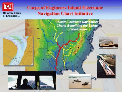
Corps of Engineers Inland Electronic Navigation Chart Initiative ...
Corps of Engineers Inland Electronic Navigation Chart Initiative ...
Corps of Engineers Inland Electronic Navigation Chart Initiative ...

Create successful ePaper yourself
Turn your PDF publications into a flip-book with our unique Google optimized e-Paper software.
US Army <strong>Corps</strong><strong>of</strong> <strong>Engineers</strong> ®<strong>Corps</strong> <strong>of</strong> <strong>Engineers</strong> <strong>Inland</strong> <strong>Electronic</strong><strong>Navigation</strong> <strong>Chart</strong> <strong>Initiative</strong><strong>Electronic</strong> <strong>Chart</strong> ECDIS COMPONENTS System ComponentsColor DisplaySPDCSEXTDNav Sensors(GPS, LORAN)SENCRadar/ARPAGyrocompassComputerAISDepthsounderENCENCDataWater levelCurrentsIce infoUpdates
US Army <strong>Corps</strong><strong>of</strong> <strong>Engineers</strong> ®<strong>Corps</strong> <strong>of</strong> <strong>Engineers</strong> <strong>Inland</strong> <strong>Electronic</strong><strong>Navigation</strong> <strong>Chart</strong> <strong>Initiative</strong>Current <strong>Chart</strong> Requirement on Western Rivers33 CFR 164.72: Vessels must carry chartpublished by NOS, USACE, or river authority.Current <strong>Chart</strong>s: 22 chart books; sole governmentchart available• 2 to 32 years old• Varying scales, features, accuracies, layout• No depth data on charts above Baton Rouge
US Army <strong>Corps</strong><strong>of</strong> <strong>Engineers</strong> ®<strong>Corps</strong> <strong>of</strong> <strong>Engineers</strong> <strong>Inland</strong> <strong>Electronic</strong><strong>Navigation</strong> <strong>Chart</strong> <strong>Initiative</strong>Objective<strong>Electronic</strong> chart data to be produced and disseminated to otherFederal agencies and the public;• Uniform format and structure suitable for e-chart applications• Maintained with updates or corrections as new survey orchannel condition information is collected• Based on the S-57 hydrographic data exchange standard• Closely coordinated with NOAA and Coast Guard• Available over the internet for free and open access<strong>Inland</strong>Coastal & Gr Lakes
US Army <strong>Corps</strong><strong>of</strong> <strong>Engineers</strong> ®<strong>Corps</strong> <strong>of</strong> <strong>Engineers</strong> <strong>Inland</strong> <strong>Electronic</strong><strong>Navigation</strong> <strong>Chart</strong> <strong>Initiative</strong>Programmanagement,proponency, fundsdispersal<strong>Corps</strong> E-<strong>Chart</strong> TeamHeadquarters,Civil WorksEngineering &OperationsConstructionE-<strong>Chart</strong> Center,ERDCRegional andcontractingcoordinationDivisionMVDLRDSADData collection andchart productionDistrict 1 District 2 District n
US Army <strong>Corps</strong><strong>of</strong> <strong>Engineers</strong> ®<strong>Corps</strong> <strong>of</strong> <strong>Engineers</strong> <strong>Inland</strong> <strong>Electronic</strong><strong>Navigation</strong> <strong>Chart</strong> <strong>Initiative</strong>Ten-Year Implementation PlanYEAR1 2 3 4 5 6 7 8 9 10Miss R: Baton R toRock Island; Ohio R,Mobile/BWT, Red,Louisiana RiversUpper Miss, Illinois,Cumberland, Tenn,Tenn-Tom, Mon,Allegheny,Kanawha, Green,Kentucky, ArkansasMissouri, Ouachita,White, Alabama,Columbia/Snake,Appalachicola<strong>Chart</strong>DevelopmentInitial <strong>Chart</strong>AvailabilityRe-survey<strong>Chart</strong>s Published andOngoing Production
US Army <strong>Corps</strong><strong>of</strong> <strong>Engineers</strong> ®<strong>Corps</strong> <strong>of</strong> <strong>Engineers</strong> <strong>Inland</strong> <strong>Electronic</strong><strong>Navigation</strong> <strong>Chart</strong> <strong>Initiative</strong>FY02 ObjectiveInitial IENC coverage for Lower and Middle Mississippi River, Ohio River,and Mobile River; charts available to public for evaluation andcommentParticipants:- New Orleans District - Louisville District - Coast Guard- Vicksburg District - Huntington District - NOAA- Memphis District - Pittsburgh District- St. Louis District - TEC- Rock Island District - CADD/GIS Center- Mobile
US Army <strong>Corps</strong><strong>of</strong> <strong>Engineers</strong> ®<strong>Corps</strong> <strong>of</strong> <strong>Engineers</strong> <strong>Inland</strong> <strong>Electronic</strong><strong>Navigation</strong> <strong>Chart</strong> <strong>Initiative</strong>FY02 Development Approach1. Data collection from existing <strong>Corps</strong> district databases; limitedre-survey and collection from other sources.2. Data structuring and conversion to S-57 format by mappingcontractors;‣ 3001 Inc – Mississippi and Mobile Rivers, Atchafalaya Riverupdate.‣ Photo Science Inc – Ohio River.3. Development <strong>of</strong> process with Coast Guard for collection andintegration <strong>of</strong> buoy data.
US Army <strong>Corps</strong><strong>of</strong> <strong>Engineers</strong> ®<strong>Corps</strong> <strong>of</strong> <strong>Engineers</strong> <strong>Inland</strong> <strong>Electronic</strong><strong>Navigation</strong> <strong>Chart</strong> <strong>Initiative</strong>IENC Feature, BuoysRed Nun, Green Can, Wreck1. Tenders with modified ECS to collectBuoy information during routine runs‣ lat/lon‣ buoy type‣ river stage2. Data sent to <strong>Corps</strong> and entered into floating aids database.3. <strong>Chart</strong> Update posted on web.
US Army <strong>Corps</strong><strong>of</strong> <strong>Engineers</strong> ®<strong>Corps</strong> <strong>of</strong> <strong>Engineers</strong> <strong>Inland</strong> <strong>Electronic</strong><strong>Navigation</strong> <strong>Chart</strong> <strong>Initiative</strong>IENC Feature, BuoysUpdated buoys shown in new chart orimported in existing chart to replaceold buoysReality <strong>of</strong> Western Rivers: Buoypositions (and existence) can changerapidly; sometimes faster than IENCupdates can be provided.
US Army <strong>Corps</strong><strong>of</strong> <strong>Engineers</strong> ®<strong>Corps</strong> <strong>of</strong> <strong>Engineers</strong> <strong>Inland</strong> <strong>Electronic</strong><strong>Navigation</strong> <strong>Chart</strong> <strong>Initiative</strong>IENC Feature; Top BankLine denoting flood stage; water at this level begins flowing into landareas, significantly altering river currents andnavigation dynamics.• Approximate line currently shown in openLower and Middle Miss. chart book (openriver)• Correct representation in IENCs not trivial;‣ line is not continuous nor constantelevation‣ comprehensive bank survey requiredTop Bank
US Army <strong>Corps</strong><strong>of</strong> <strong>Engineers</strong> ®<strong>Corps</strong> <strong>of</strong> <strong>Engineers</strong> <strong>Inland</strong> <strong>Electronic</strong><strong>Navigation</strong> <strong>Chart</strong> <strong>Initiative</strong>IENC Content Specification• Defines 56 features with 50 attributes in S-57 structure, full ENCcompliance.• Based on industry input and Mississippi and Atchafalaya Pilotprojects• Most features to be included in FY02development, although may not havesufficient accuracy• Content Spec availablefor reviewPilot IENC on MississippiRiver at VicksburgPilot IENC on Atchafalaya River at Morgan City
US Army <strong>Corps</strong><strong>of</strong> <strong>Engineers</strong> ®<strong>Corps</strong> <strong>of</strong> <strong>Engineers</strong> <strong>Inland</strong> <strong>Electronic</strong><strong>Navigation</strong> <strong>Chart</strong> <strong>Initiative</strong>Possible S-57/ENC DeviationsFeatures that don’t have clear or suitable fit:• Sailing Line – no object for non-centerline, varying orientation• Vertical Datums – LWRP and Project Pool not included• Riverbank/Coastline – “Riverbank” not allowed; eventually, featuresmay not be fixed• Fleeting Area – Category and Restriction attributes don’t fit• Ice Breaker – Floating structures that don’t have effective attributionProblem solved by ECS – metric depths, contours and heights, thatneed to be displayed in English units.
US Army <strong>Corps</strong><strong>of</strong> <strong>Engineers</strong> ®<strong>Corps</strong> <strong>of</strong> <strong>Engineers</strong> <strong>Inland</strong> <strong>Electronic</strong><strong>Navigation</strong> <strong>Chart</strong> <strong>Initiative</strong>European <strong>Inland</strong> ECDIS StandardVery detailed and specific standard with extensions to the S-57/ENCStandard; includes performance and display requirements.• <strong>Corps</strong> to consider use <strong>of</strong> several components;+ consistency <strong>of</strong> U.S. and European inland charts- some features and attributes not applicable to U.S.• Currently, <strong>Corps</strong> applying S-57 ENC product specification andtesting for suitability.
US Army <strong>Corps</strong><strong>of</strong> <strong>Engineers</strong> ®<strong>Corps</strong> <strong>of</strong> <strong>Engineers</strong> <strong>Inland</strong> <strong>Electronic</strong><strong>Navigation</strong> <strong>Chart</strong> <strong>Initiative</strong>Display Standard• Not included in S-57, and USACE traditionally does not specify what orhow charts are to be used;……but;• ECDIS and ECS are systems in which components and userprocedures are not mutually independent;……and;• Coast Guard defers to the hydrographic authority to define properchart utilization.‣ S-52, colors and symbols, to be used during river tests. <strong>Corps</strong> andCoast Guard to seek input from industry on S-52 suitability.