Proposed Genetic Model For The Precipitaton Of Uranium In ...
Proposed Genetic Model For The Precipitaton Of Uranium In ...
Proposed Genetic Model For The Precipitaton Of Uranium In ...

Create successful ePaper yourself
Turn your PDF publications into a flip-book with our unique Google optimized e-Paper software.
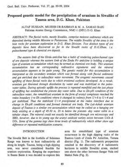
Geol. Bull. Univ. Peshawar, Vol. 37, pp. 89-99, 2004ALTAF HUSSAIN, MUJEEB-UR-RAHMAN & M. A. SAMAD BAIGPakistan Atomic Energy Commission, NMC- 1 (DEU) D. G. KhanABSTRACT: <strong>The</strong> fluvial rocks, mostly Siwaliks, comprise molasse sediments which aredeposited during middle Miocene to Pleistocene. <strong>The</strong> middle Siwaliks of the area is thehost rocks for uranium exploration in D.G. Khan Division. Two distinct types of oredeposits have been discovered so far in the Siwalik rocks of D.G.Khan, i.e.paleochannel type & chemical ore deposit.<strong>The</strong> eastern limb of the Girdu anticline has a habit of rendering paleochannel typeof ore deposits whereas the eastern limb of the Zinda Pir anticline is holding a uniquetype of uranium accumulation which may be termed as chemical ore body. llis uraniumaccumulation has no corresponding radioactive signatures and the mineralaccumulation appears to be quite young. <strong>The</strong> genetic model for this accumulation isinterpreted as the secondary uranium which was formed along with fluvial sedimentsand got enriched due to subsurface water movement. <strong>The</strong> orogenic movements causedupliJting of these fluvial rocks due to which erosional suvaces developed. As a result,uranium got liberated through dissolution by water and was mobilized to the paleowatertables. During episodic uplifts the process is repeated manifold and the last phaseof uplifting has established the present day water table. Due to Eh-pH condition of thesubsuvace water, the remobilized uranium in the form of uranyl complexes reached theredox boundary (-ve Eh condition) where it changed its valency from U+6 to U+4 andgot stabilized. Thus the stabilized U+4 precipitated at the redox interface due tochange in Eh-pH conditions and formed chemical ore body, <strong>The</strong> Lal-Ashab uraniumdeposit of Taunsa is a similar ore accumulntion which may be called as a hanging orebody existing at a depth of 45-50 m, 20 m below the present- day water table in atabular shape. <strong>The</strong> mineral could )tot exactly be identiped through ore microscopy andXRD, however, due to its young age the uranyl oxidized variety exists between U3Os &UO2. Some of the gamma logs show three levels of radioactivity which either show agediflerence or repeated mobilization scenario.INTRODUCTION area for remobilized type of uraniumoccurrence in the high dipping rocks of the<strong>The</strong> Siwalik Belt in the foothills of Sulaiman Eastern Limb of Zinda Pir Anticline, TanusaRange was known to host radioactivity all district (Fig. 1). <strong>The</strong> radiometric prospectionalong its length. Taunsa, being a high dipping resulted in the discovery of 4 radiometricarea, was never considered feasible for horizons in middle Siwaliks strata, stackeduranium exploration. Keeping the experience one above the other between Sangar Nala andin Bannu Basin it was decided to explore this Mahoi Nala (Fig. 2).
Fig. 2. Geological map of Taunsa area showing radioactive anomalous zones (Unpublishedreport of PAEC, D .G. Khan).as:<strong>The</strong>se radioactive horizons were named1. Lal-Ashab uraniferrous horizon.2. Fowl Creek uraniferrous horizon.3, Zamdani uraniferrous horizon.4. Ghazzi uraniferrous horizon.All the horizons were sampled at variouslocations for chemical analysis of uraniummineralization. <strong>The</strong> microscopy and XRDmethod is CARNOTITE {KZ(U02)2V208).REGIONAL TECTONIC FRAMEWORK<strong>The</strong> Sulaiman lobe (Sarwar & DeJong, 1979)> 300 krn broad, lying to the southwest of theHimalayas is a tectonically active fold andthrust belt. <strong>The</strong> main structural elements in theSulaiman fold belt are E-W trending arcuate,analyses depict (Table 1) that most of theradioactive surface samples are devoid ofchemical uranium which indicate pronouncedleaching phenomena. This tendency helps toexplore the possibility of accumulation ofchemical uranium as a result of leaching,mobilization and re-precipitation in thesubsurface.
TABLE 1.ROCK SAMPLE ANALYSES COLLECTED FROM PROJECT AREASpot Sample UIOaLocation# Sample No. Reading Reading(NGR) CpS%CPSTauIZdn-45 652800 100Sample DescriptionGrey sands tone.Grey sandstone.Grey sandstone.Grey sandstone.Grey sandstone.Grey sandstone with clay balls.Grey sandstone with clay balls.Grey sandstone having visibleuranium mineralization.Grey sandstone having visibleuranium mineralization.Grey sandstone having visibleuranium mineralization alongwithclay balls.Grey sandstone having visibleuranium mineralization.Grey sandstone having visible60 uranium mineralization.However, some of the radioactive rockssamples of the remanent ore body do havechemical uranium. <strong>The</strong> mineral of rocksamples identified through ore convex to thesouth folds and faults which rotate rapidly tonorth-south direction along the margin of theactive fold belt. Imbricate faults visible at thesurface in the hinterland gradually disappeartowards the deformation front (HuntingSurvey Corporation, 1961 ; Kazmi & Rana,1982). <strong>The</strong> Sulaiman fold and thrust belt isdeveloped by transpression as a result of leftlateral strike slip motion along the Chamanfault zone and southward thrusting along thewestern boundary of the <strong>In</strong>dian subcontinent(Sarwar & Lawrence et al., 1981; 1984).<strong>The</strong> eastern Sulaiman Range is composedof the N-S trending Zinda Pir anticline in theeast and Girdu (<strong>For</strong>t Munro) anticline in thewest with Barthi-Baghal Chur syncline as theintervening basin (Wang et. al., 1996). ZindaPir anticline which is also known as Zinda Piranticlinoriurn (Iqbal & Ali, 1997) is aprominent structural element lying in thefrontal part of the Sulaiman Fold belt. Itcomprises four main anticlines which fromnorth to south are Dhodak, Rhodo, Afibandand Zinda Pir proper (Iqbal & Ali, 1997).<strong>The</strong> 3rd Episode of the HimalayanOrogeny is characterized by the initiation andgradual development of Himalayan foldedthrust belt, Sulaiman folded thruyt belt andChaman shear fault. Due to ongoing collisionof the <strong>In</strong>dian and Eurasian Plates, a fore deepbasin developed along the southern fringes ofthe Himalayan Orogenic belt and eastern most
part of the Sulaiman Fold and Thrust beltwhere uplifting Himalayas shed its erosionalmaterial. Actually this fore deep basin hascontrolled the initiation and development ofthe Paleo-<strong>In</strong>dus river .system as well as theformation and layout of Siwalik rock series.<strong>The</strong> basin is now uplifted and deformed,representing the southward progression ofHimalayan deformation.Episode-IV of the Orogenic movement is thestage of strong compressional stresses formingthe tectonic framework of the Sulaiman Range.During this episode N-S trending and plungingZinda Pir anticline has also formed as a result ofwhich the Paleo-Lndus River has migrated andsgfted further east to its present course of flow.Zinda Pir anticline runs parallel to the axis ofGirdu anticline towards east and is separated byBarthi-Bagd chur - Sakhi Sarwar syncline. ThisAnticlinal zone marks the eastern boundary of theSulairnan <strong>For</strong>e deep. A complete conceptualdiagram illustrating tectonic development of theSulaiman uranium mineral belt during theHimalayan orogeny is given in Fig. 3 (Wang et.al., 1996).<strong>The</strong> investigated area is a part of theeastern flank of Zinda Pir anticline thatexposes Siwaliks on eastern extremities of theSulaiman Range. <strong>The</strong> Sulaiman Range in thearea contains four terrace levels which arerelated to the last episode of Himalayanorogeny. <strong>The</strong>se terraces representpaleopeneplain levels which are related toeperiogenic periods within the last episodei.e. fifth episode.GEOLOGY OF PROJECT AREA-Tkewaaium minerakahmrthearea occursinfluvial sedimentary rocks of middleMiocene to Quaternary ages, which make apart of middle Siwalik of the easternSulaiman Range. <strong>The</strong> Siwalik groupcomprises of Vihowa <strong>For</strong>mation (LowerSiwaliks), Litra <strong>For</strong>mation (Middle Siwaliks)and Chaudwan <strong>For</strong>mation (Upper Siwaliks).Siwaliks sequence represents diverselithological and sedirnentological featuresshowing various phases of depositionalenvironment. Lower Siwaliks predominantlyconsists of maroon to red claystone of sandyand silty nature inter-bedded withcomparatively thick sandstone and reddishbrown shale units.<strong>The</strong> middle Siwaliks consist of a varietyof sandstone units which are mostly thickbedded, however, thin hard bands of bothepigenetic and syn-genetic nature and lessfrequent scouring surfaces are also present.<strong>The</strong>se thin-bedded hard bands are in the formof clusters and commonly developed in upperpart of the middle Siwaliks in a discontinuousfashion. Thick-bedded hard band are wellcontinuous, highly calcified and most frequentin lower part. Shale to sandstone ratio is quitehigh in upper part, whereas shales are lesscommon in lower part. <strong>The</strong> radiometricsandstone of the area is medium to coarsegrained; at places gritty and greenish grey,mainly cross-bedded with abundantradiometric trash pockets and carbonaceousmatter. Radioactive vertebrate fossils areuncommon. <strong>The</strong> contact between middle andlower Siwaliks is conformable andtransitional.Upper Siwaliks comprise pebbleconglomerates,coarse gritty sandstone andreddish brown shale units. <strong>The</strong> contactBetween mime a M uppe SiwgiiE isconformable and gradational.
WSTAGE OF MULTCPHA- 3REFORMLlTlOH OF* -LAHIUM ORE BODIESDOsraGe OF FORMATION ANTICU%OF TECTONIC FRAMEWORK OF THE STUDYSYHCLiNEZlNDA PIRANTICLINEYAF,",","STAGE OF THE SOAN 7FORMATION DEPOSlTlONI)cMAIN-;--PALE0 INDUS. DRAINAGESTAGE OF THE DEVEL-OPMENT OF THEFOREDEEP BASIN l ANDNOFT 'HESTAGE OF THE BEGINNINGOF THE COWTlHENTALFOREDEEP DEPRESS-SlOM BASIN.STAGE OF THEPRE-SIWLLLIK FORM-ATION DEVELOPMENTIt4 MARINEEMVlRONMf NT.PETRITAL SEDIMENT FEEDING-UPLIFmG-1 EXPANSION-*?7EOCENE.OLICC)CENELATE-CRETACE WS TOPALEOCENEFERRUGIHOUS CRUST OFWWHERINGFLUVIAL-CONGLOMERATEUNCONFORMITYINFERRED FAULTLIMESTONE & SANDSTOHESUB MOUSSE PRE.MESOZOICEASEMENTURANIUM ORE BODYFig. 3. A complete conceptual diagram illustrating tectonic development of' the sulairnan<strong>Uranium</strong> Mineral Belt during the Hima-Layan Orogeny (dimensinns not to scale)(modified after Wang et al,, 1996).
GENESIS OF SUBSURFACE URANIUMACCUMULATION IN THE AREA<strong>The</strong> uranium accumulation is ribbon-shaped,tabular hanging structure that follows thestrike direction. <strong>The</strong> width of surfaceradioactivity of uraniferrous horizon is 30 m,but the subsurface width of uraniumaccumulation is up to 82 m i.e., the spread ofuranium in the subsurface is more than thecorresponding surface radiometry. <strong>The</strong>average thickness of the ore lenses is 5 meter.This uranium is remobilized 1 reworked,which is accumulated at the expense ofleaching and remobilization of pre-existingsurface anomalies at redox boundary thatexists at a depth of 45-50 m, 20 m below thepresent day water table (Fig. 4).A comparison of the character of thecharacter of oxidation zone, transitional zone andreducing zone is given in Table 2 and 3, <strong>The</strong>subsurface uranim accumulation with weakradioactivity predicts the following workinghypothesis. <strong>The</strong> sediments hosting the ore bodywere deposited in a fluviatile environment withsufficient supplies of airborne volcanic matter &uranium from the primary rocks.<strong>The</strong> uranium in this area is derived fromsyndeposited volcanic ejecta in the form ofvolcanic ash fdls and tuffs. <strong>The</strong> volcanics aremore prone to enter into oxidized humidenvironment to liberate uranium. <strong>The</strong> liberationof uranium took place during diagensis whenthese sediments were partially altered. Thismobilized uranium got fixed with the carbon richpaleo-channel type sediments to form the initialore body, which is still visible on the surface withgrey clay balls, carbonaceous trash pockets andhaernatitized organic matter. As a result oforogenic movement, the sediments underwentintense folding due to which tectonic uplift of thearea took place. <strong>The</strong> uranium got liberatedthrough dissolution by ground water and wasmobilized to the paleo water table. Duringperiodic uplift the water table of the arearepeatedly got lowered. <strong>The</strong> precipitated uraniumhad continuously been oxidized upon uplift andthe redox boundary had gradually been shifteddownward to the next stage contemporaneous tothe phases of uplift. Gamma logs of the ore bodyrepresent three levels of uranium accumulation,which either show age difference or repeatedmobilization-precipitation scenario. <strong>The</strong>se threegeneration peaks indicate reprecipitationremobilizationphenomenon (Fig. 5).Fig. 4. Conceptual diagram depicting the mode of leaching of uranium from the surface outcrop and corresponding accumulation in the sub surface below ground water table.95
TABLE 2.ROCK SAMPLES ANALYSES OF THE OXIDIZED ZONEUs08Ferrous# Chemical U+4 U+6IronOrganicIron asMoo3 VzOs~e'*/~e'~ Cas FeOFez03% % % % % % ppm ppm0.041 0.007 --- ND 163.68022 0.008 0.0081 --- 5.050 0.037 0.007 0.360 ND 56.990TABLE 3CORE SAMPLE ANALYSES OF TRANSITION AND REDUCING ZONETotal Iron as Iron as vanal n# FRO^ % FeO %%(on dry basis)
uplifting. This water table has controlled theaccumulatiop of uranium in the form of ahanging ore body. Hydrochemical characterof the ground water is given in Table 4. <strong>The</strong>presence of free oxygen made the uppersurface of water oxidized. With depth,oxygen become lesser and ultimately becamenon-existent thus the conditions becamereducing that made Eh negative. <strong>The</strong>remobilized uranium, by reaching to redoxboundary, changed its valency from +6 to+4 and got stable because U +4 is alwaysstable in negative Eh conditions, andultimately re-deposited there. <strong>The</strong> uraniumore, formed at the end of secondarymobilization is so young in age that noradioactivity is associated with it; thisradioactive signature cannot be used forarithmetic assessment of the subsurfaceuranium ore body.CONCLUSIONSFig. 5. Gamma Log of Taunsa areadepicting three different levels ofuranium accumulations.----- - --------- -<strong>The</strong> present day water table wasestablished as a result of last episode of<strong>The</strong> chemical ore body is emplaced as a resultof trickling down of surface uraniummineralization available at expense of surfaceradiometry. <strong>The</strong> uranium accumulated belowthe ground water table, where Eh-pHconditions are favorable for precipitation.This ore body is formed at its present locationthrough leaching, remobilization andaccumulation at redox boundary. Gamma logof the ore body represent three levels ofuranium accumulation, shdws repeatedmobilization-precipitation phenomenon. <strong>The</strong>uranium ore formed at the end of secondarymobilization is too young in age that noradioactivity is associated with it. Watersamples collected from different holes of orebody indicates that pH remains slightlyalkaline. <strong>The</strong> Eh versus pH conclude that theintersect lies in the area of slightly alkalinemedium. -During-anatysts of-core-samples it isobserved that uranium is easily leachable witheven fresh water and drilling mud.
TABLE 4.HYDROCHEMICAL CHARACTER OF THE PRESENT DAY GROUND WATERsamples samples samples samples samples samples samples samples samples samples samples samples samples# Constituents No. No. No. No. No. No. No. No. No. No. No. No. No.W-1 W-2 W-3 W-4 W-5 W-6 W-7 W-8 W-9 W-10 W-11 W-12 W-13PH 7.710 7.850 7.820 7.690 7.710 7.830 7.700 7.730 7.790 7.750 7.750 7.680 7.840Emf (mv)Temprature<strong>Uranium</strong> asu308Bicarboanteas HC03 -'Sulphate asso4Cloride C1CaIsium asCa+2MagnessiumMg+ZSodium asNa+ '221.900 211.500 211.500 211.400CO 25.000 30.000 30.000 30.000PPm0.370 0.370 0.330 0.340PPm218.700 218.700 218.700 218.700PPm274.510 245.850 254.90 260.180ppm 40.000 36.000 36.000 32.000PP*76.950 66.530 65.730 65.730PP*43.770 39.400 39.880 40.860PPm70.190 70.190 72.120 75.960Potassium 14.850 8.510 5.520 7.010 7.420 7.200 7.420 7.390 7.570 7.800 7.910 6.720 6.830as K+' PPmSilica as 14.210 14.010 14.060 13.820 14.020 13.890 13.690 13.750 13.430 13.130 13.280 13.650 13.480SiOz PPmIron as 0.570 0.510 0.110 0.020 0.730 0.092 0.074 0.130 0.110 0.330 0.280 0.074 0.090Ferrous ~e+' ppmIron as 0.110 0.140 0.140 0.057 0.077 0.058 0.066 0.070 0.060 0.100 0.060 0.076 0.096Ferric Fe +3 PPmIron Total 0.680 0.650 0.250 0.077 0.150 0.150 0.140 0.200 0.170 0.430 34.000 0.150 0.190m" Em PPm
REFERENCESHunting Survey Corporation, 196 1.Reconnaissance Geology of part of WestPakistan. A Colombo plan cooperationproject. Government of Canada,Geodynarnics, Toronto.Iqbal, M. & Ali, S.M. 1997. A possible roleof strike slip fault related tectonics in thedevelopment of Zindapir anticlinorium,Pakistan. Unpubl. Rep. Hydroc. <strong>In</strong>st.Pakistan.Lawrence, R. D., Khan, S.H., Dejong,K.A., Farah, A. & Yeats, R.S., 1981. Athrust and strike slip fault interactionalong Chaman fault zone, Pakistan, <strong>In</strong>:Thrust and nappe Tectonics (K.R.Maclay & N.J. Price, eds.), Geol. Soc.London, Spec. Publ., 363-370.Sarwar, G., & Dejong, K.A., 1979. Arcs,Oroclines, syntaxes. <strong>The</strong> Curvature ofmountain belts in Pakistan. Geodynamicsof Pakistan, Geol. Surv. Pak., Quetta.Wang, Z.B., Tang, S.G., Chen, D. & Nie, F.,1996. Basic geological studies andpreliminary evaluation of uranium potential ofSiwaliks in the middle part of Sulairnanmineral belt Pakistan. Unpubl. PAEC Report.