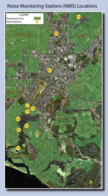
Noise Monitoring Stations (NMS) Locations - John Wayne Airport ...
Noise Monitoring Stations (NMS) Locations - John Wayne Airport ...
Noise Monitoring Stations (NMS) Locations - John Wayne Airport ...
- No tags were found...

You also want an ePaper? Increase the reach of your titles
YUMPU automatically turns print PDFs into web optimized ePapers that Google loves.
19L 19R<strong>Noise</strong> <strong>Monitoring</strong> <strong>Stations</strong> (<strong>NMS</strong>) <strong>Locations</strong>LEGENDResidential Area<strong>Noise</strong> Monitor#SANTA ANATUSTINCOSTA MESA01R01LIRVINENEWPORT BEACHNorth
JOHN WAYNE AIRPORTPERMANENT NOISE MONITORING STATIONS<strong>NMS</strong> DISTANCE (FEET) MICROPHONE LATITUDE REMARKS:SITE LOCATIONSHEIGHTANDAND NUMBERING FROM NORTH 90DEGREETOLONGITUDE 1. Length of Runway 19R/1LENDEXT.CL EXTENDED5700.04 FeetRNWY19R/1L C/L 19R/1L AGL ARLN ARLS2. Runway Elevation, North End, 19R,<strong>NMS</strong> Golf CourseGPS1409 EL = +39.23 Feet MSLlS 3100 Irvine Ave. 8,799.7' S'LY 939.1' W'LY 23.1 ' +27.1' +12.5' 33° 39' 41.34315" NNewport Beach117° 52' 52. 76360" w3. Runway Elevation, South End, 1L,<strong>NMS</strong> 20152 Birch St 8,752.0' S'LY 1,184.1' E'LY 34.6' +48.7' +34.1' 33° 39' 31.92912" NGPS1410 EL = +53.79 Feet MSL2S Newport Beach117° 52' 30.30179" w<strong>NMS</strong> 2139 Arutiversary Ln. 10,799.2' S'LY 168.7' E'LY 23 .2' +5.3' -9.3' 33° 39' 18.73355" NJS Newport Beach117° 52' 52.25295" w4. AGL =Above Ground Level<strong>NMS</strong> 2338 Tustin Avenue 14,155.7' S'LY 1,998.9' W'LY 23.2' +57.1' +42.5' 33° 38' 59.42269" N5. ARLN =Above Runway Level, North4S Newport Beach117° 53' 33.49379" wEnd<strong>NMS</strong> 324 Y2 Vista Madera 14,938.7' S'LY 1,945.0' E'LY 24.6' +47.8' +33.3' 33° 38' 34.31939" Nss Newport Beach117° 52' 56.60114" w6. ARLS = Above Runway Level, South<strong>NMS</strong> 1912 Santiago 17,559.7' S'LY 241.7' E'LY 24.1' +86.8' +72.2' 33° 38' 19.28931" NEnd6S Newport Beach117° 53' 28.91310" w<strong>NMS</strong> 1311 Back Bay Dr. 23,960.9' S'LY 3,292.6' E'LY 28.8' +39.8' +25.3' 33° 37' 09.19975" N7S Newport Beach117° 53' 32.44970" w7. Lat & Long of Ends of Runway 19R/1L<strong>NMS</strong> 17372 Eastman St. 6,533.1' N'LY 58.1' E'LY 38.0' +36.1' +21.5' 33° 41' 50.76324" N North End (19R) 33° 40' 53.92311"8N Irvine117° 51' 17.40197" w (GPS1409) 117° 51' 54.20806"<strong>NMS</strong> 1300 S. Grand Ave. 18,052.4' N'LY 5,113.0' W'LY 57.5' +109.9' +95.3' 33° 43' 55.40983" N9N Santa Ana117° 51' 07.63734" w South End ( lL) 33° 40' 04.09333"<strong>NMS</strong> 17952 Beneta Way 28,781.8' N'LY 631.3' E'LY 25.0' +126.5' +111.9' 33° 45' 02.57051" N (GPS1410) 117° 52' 25. 78055"lON Tustin117° 49' 08.02769" wSURVEYORS NOTES:1. Horizontal datum for this project is:CCS83, ZONE VI, 1991.35 EPOCH OCS, GPS ADWSTMENT2. Vertical Datum: NGVD29, 1995 OCS ADWSTMENT3. Distances shown are ground distances. To obtain grid distance multiplyground by CF=0.999974834. Coordinates are per "JWA RUNWAY'S & T AXJ.WAY'S CENTER LINESALIGNMENT MAP" dated September 2002, File #JW A684, on file with<strong>John</strong> <strong>Wayne</strong> <strong>Airport</strong> Facilities, Translated to NAD83 Geographic Coordinates.TillS REPORT WAS PREPARED BY ME OR UNDER MY SUPERVISION ANDIS BASED ON A FIELD SURVEY PERFORMED BETWEENOCTOBER 2002 AND MARCH 2003.~ A.a.~tc-ANDREw A. RZYSKO, S 7406SENIOR LAND SURVEYOR JW Ao~/~1fo3DATE