Fall - Saskatchewan Land Surveyors Association
Fall - Saskatchewan Land Surveyors Association
Fall - Saskatchewan Land Surveyors Association
- No tags were found...

You also want an ePaper? Increase the reach of your titles
YUMPU automatically turns print PDFs into web optimized ePapers that Google loves.
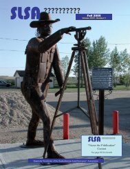
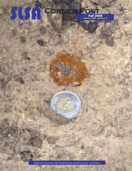
263 - “Canadian Spatial Reference System” 282 - “ Scrutinizing Survey Monuments”While geodetic reference frames underpin the measurementsof the motions and slow deformations of theEarth’s crust, these geophysical processes also systematicallyaffect the reference frames provided as standardsfor geodetic surveys. In Crustal Motion and DeformationMonitoring of the Canadian <strong>Land</strong>mass, some of NRCan’sefforts to monitor contemporary crustal dynamics acrossCanada are reported. Progressing from continental tosmaller regional scales, the rationale, techniques, andresults are outlined in this paper. While the required observationaldata and interpretations are fundamentallydependent on the Canadian Spatial Reference System,they in turn also contribute to the incremental improvementof its definition and maintenance.In this era of global technologies, modern referenceframes require alignment with a global “standard.” Collectivelyrealized by geodetic agencies around the worldunder the auspice of the International <strong>Association</strong> ofGeodesy (IAG), the International Terrestrial ReferenceFrame provides this foundation. Recognizing the needfor better coordination of international efforts to satisfylong-term requirements, the IAG has initiated the GlobalGeodetic Observing System (GGOS) project and has specificallytasked a working group to develop a strategy tofurther integrate and maintain the fundamental geodeticnetwork of instruments and supporting infrastructurein a sustainable manner. In Global Geodetic ObservingSystem - Considerations for the Geodetic Network Infrastructure,a global integration process is proposed thatincludes the development of a network of fundamentalstations with co-located geodetic techniques and preciselydetermined inter-system relationships. The designof this network would exploit the strengths of each techniqueand minimize the weaknesses where possible. Thepaper summarizes the present state of the infrastructureand provides a road map to future global geodetic networks,services, and products.In closing, I would like to thank all contributing authors,including those whose papers were not selected for publicationin this Special Issue. For the papers not presentedhere, I look forward to their possible publication in futureissues of Geomatica. Special thanks to Pierre Herouxwho has taken on the coordination of this effort withinthe Geodetic Survey Division and without whom this issuewould have not materialized. Finally. I would like toextend my thanks to Kelly Dean, Editor, Geomatica andCarol Railer, Production and Advertising Manager, forfacilitating the publication of this special issue and, despitea very tight schedule, for being so accommodatingat the final editing stages of this production. Let us be mindful of the two fundamental conditionswhen it comes to scrutinizing survey monuments andassessing of evidence:(1) the monument is the original monument placed bythe original land surveyor for the specific purpose;and(2) the monument is where the original land surveyorplaced it.If both conditions are met, the monument governs theboundary at its original position. The monument canstill govern the corner, even if it may appear that a blunderhas been made in placing a monument for an originalsurvey. No amount of discrepancy between measurementsand the physical location of the monumentchanges the fact that the monument governs, providedthat the two mentioned conditions are met.A bent statutory iron post does not necessarily mean itis disturbed, destroyed, or lost when traces or remnantsof the original monument are still there, perhaps hiddenaway. Look thoroughly, research deeply and ask questions,for the evidence you are overlooking today willstill be there tomorrow. Today is the time to think abouthow you want to be remembered tomorrow! December 23. 1898Christmas dinner on the plainsA.F. Martin, D.L.S., who is subdividing intp. 21, Gilbert Plains, expects to be throughin that vicinity by Christmas time, and thencommence work in the Riding Mountain intp. 23. r. 18, southwest of the Ochre.At the completion of his work at the Ochrehe will then proceed to the Swan decisionwith its party. Mr. Martin says the land ofGilbert Plains is unsurpassed in quality andthat new settlers were on {his} heels to locateas fast as the land was surveyed.A special and pleasant feature on Mr. Martin’strip to town was to procure supplies forhis camp for Christmas with which he intendedto give the boys a right royal feast.“There is no place,” said the veteran surveyor,“where a man enjoys his Christmasdinner like on the open plain with the broadcanopy of heaven for his roof.”Gleaned from the fi les of J.H. Webb, SLS, Life Member284 SLSA Corner Post <strong>Fall</strong> 2006