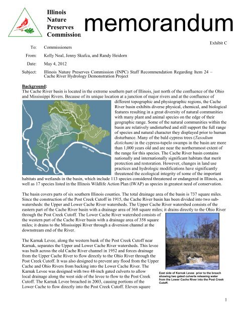
To:From:<strong>Illinois</strong>NaturePreservesmemorandum[Type text]CommissionCommissionersKelly Neal, Jenny Skufca, and Randy HeidornDate: May 4, 2012Subject: <strong>Illinois</strong> Nature Preserves Commission (INPC) Staff Recommendation Regarding Item 24 –Cache River Hydrology Demonstration ProjectExhibit CBackground:The Cache River basin is located in the extreme southern part of <strong>Illinois</strong>, just north of the confluence of the Ohioand Mississippi Rivers. Because of its unique location at a junction of major rivers and at the confluence ofdifferent topographic and physiographic regions, the CacheRiver basin exhibits diverse physical, chemical, and biologicalfeatures resulting in a great diversity of natural communitieswith many plant and animal species on the edge of theirgeographic range. Some of the natural communities within thebasin are relatively undisturbed and still support the full rangeof species and natural character they displayed prior to humandisturbance. Many of the bald cypress trees (Taxodiumdistichum) in the cypress-tupelo swamps in the basin are morethan 1,000 years old and are near the northernmost extent ofthe range for this species. The Cache River basin containsnationally and internationally significant habitats that meritprotection and restoration. However, changes in land usepractices and hydrologic modifications have significantlythreatened the ecological integrity of some of the importanthabitats and wetlands in the basin, which include 113 species considered threatened or endangered in <strong>Illinois</strong>, aswell as 17 species listed in the <strong>Illinois</strong> Wildlife Action Plan (IWAP) as species in greatest need of conservation.The basin covers parts of six southern <strong>Illinois</strong> counties. The total drainage area of the basin is 737 square miles.Since the construction of the Post Creek Cutoff in 1915, the Cache River basin has been divided into two subwatersheds:the Upper and Lower Cache River watersheds. The Upper Cache River watershed consists of theeastern part of the Cache River basin with a drainage area of 368 square miles; it drains directly to the Ohio Riverthrough the Post Creek Cutoff. The Lower Cache River watershed consists ofthe western part of the Cache River basin with a drainage area of 358 squaremiles; it drains to the Mississippi River through a diversion channel at thedownstream end of the River.The Karnak Levee, along the western bank of the Post Creek Cutoff nearKarnak, separates the Upper and Lower Cache River watersheds. This leveewas built across the old Cache River channel in 1952 and forces drainagefrom the Upper Cache River to flow directly to the Ohio River through thePost Creek Cutoff. It was also designed to prevent any flood from the UpperCache and Ohio Rivers from backing into the Lower Cache River. TheKarnak Levee was designed with two 48-inch gated culverts to allowlocal drainage along the west side of the levee to flow to the Post CreekCutoff. The Karnak Levee breached in 2003, causing portions of theLower Cache to flow directly into the Post Creek Cutoff. Eleven squareEast side of Karnak Levee prior to the breachshowing two gated culverts releasing waterfrom the Lower Cache River into the Post CreekCutoff.1
miles of the Lower Cache River watershed flowed eastward through the breach and culverts, draining into theOhio River via the Post Creek Cutoff reversing the flow through this portion of the original channel.Prior to the breach, drainage from the Lower Cache River watershed wasassumed to flow west into the Mississippi River. However, a considerableamount of water from the eastern portions of the Lower Cache Rivercurrently flows east to the Post Creek Cutoff. This easterly flow alsooccurred during flood events prior to the breach when both the Ohio andMississippi Rivers were above flood stage. The hydraulics of the LowerCache River are very complex. Since the division of the Cache River basininto two watersheds, the Lower Cache River does not receive flow from theUpper Cache River to maintain a sustained flow in the downstreamdirection. 1Exhibit CClearer water draining from the Lower CacheRiver flowing from the breach in the KarnakLevee as it enters the Post Creek Cutoff.The Cache River basin has experienced impaired water quality thatthreatens its biodiversity; much of this is due to human modifications to the aquatic and terrestrial watershed(IEPA 2008) 2 . Rivers need free-flowing water. The gentle current of a free-flowing river brings oxygen anddissolved nutrients, while also moving pollutants out of the system. A river and its connected natural areas aremost healthy, diverse, and sustainable when water is flowing through them. Further, aquatic animals must be ableto move freely to find suitable habitat for breeding and survival during periods of drought.A current initiative of the Joint Venture Partnership, which includes Ducks Unlimited Inc., the <strong>Illinois</strong>Department of Natural Resources (I<strong>DNR</strong>), the Natural Resource Conservation Service, The Nature Conservancy,and the U.S. Fish and Wildlife Service, is to restore flow variability and physical connectivity between the upperand lower segments of the Cache River. This is also a goal in the IWAP, as well as the management plans forLower Cache River “Reserve” which includes Section 8 Woods Nature Preserve and Buttonland Swamp, a part ofCache River Land and Water Reserve and a National Natural Landmark.Proposal:The restoration project to reconnect the Upper and Lower Cache River channels has been postponed in order toaddress water quality issues and ecological integrity in the Lower Cache. Although the U.S. Army Corps ofEngineers and the <strong>Illinois</strong> State Water Survey have provided critical information about how water flows throughthe system, additional detail is needed to advance this project into final design and planning. Southern <strong>Illinois</strong>University-Carbondale (SIUC) sought and received a State Wildlife Grant titled, “Demonstrating the benefits ofStream Restoration to Aquatic Communities in the Cache River Basin.” In the grant, SIUC proposed a pilotproject that would assess and demonstrate the effects of increasing stream flow on oxygen dynamics andmacroinvertebrate communities in the Lower Cache River. This project has the potential to demonstrate thebenefits of restoring even, low flows to the Lower Cache system. Data obtained should aid in selecting thepathway and designing the channel/connection structure necessary to rejoin the upper and lower segments of theCache River.Two options for conducting this demonstration have been proposed by SIUC. The first option has beendetermined to be the best possible demonstration design, while the second option attempts to take into accountcertain limitations presented by the state’s recent litigation concerning that section of the Cache River.Preferred Option:Reconnection would be simulated by creating flow in the Lower Cache River east of State Route 37, monitoringfour sites and comparing them to four reference sites in the Upper Cache River. Dissolved oxygen, primaryproduction, turbidity, and duckweed cover would be assessed. Results would allow quantitative assessment ofchanges in dissolved oxygen and stream metabolism to increased flows. The pilot project should also help todetermine how increasing flow in the Lower Cache channel would affect the production, abundance, and diversityof macroinvertebrate communities through sampling.2