LAI determination in forestry ecosystem by LiDAR data analysis
LAI determination in forestry ecosystem by LiDAR data analysis
LAI determination in forestry ecosystem by LiDAR data analysis
- No tags were found...

Create successful ePaper yourself
Turn your PDF publications into a flip-book with our unique Google optimized e-Paper software.
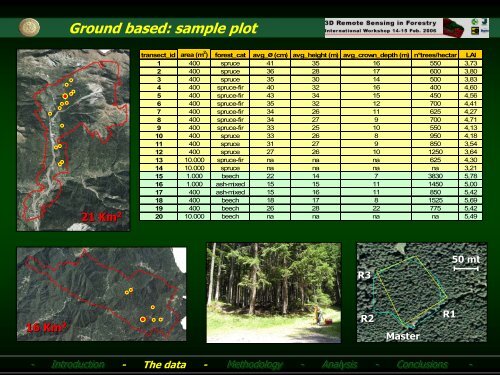
Ground based: sample plot21 Km 2transect_id area (m 2 ) forest_cat avg_ø (cm) avg_height (m) avg_crown_depth (m) n°trees/hectar <strong>LAI</strong>1 400 spruce 41 35 16 550 3,732 400 spruce 36 28 17 600 3,803 400 spruce 35 30 14 500 3,834 400 spruce-fir 40 32 16 400 4,605 400 spruce-fir 43 34 15 450 4,566 400 spruce-fir 35 32 12 700 4,417 400 spruce-fir 34 26 11 625 4,278 400 spruce-fir 34 27 9 700 4,719 400 spruce-fir 33 25 10 550 4,1310 400 spruce 33 26 8 950 4,1811 400 spruce 31 27 9 850 3,5412 400 spruce 27 26 10 1250 3,6413 10.000 spruce-fir na na na 625 4,3014 10.000 spruce na na na na 3,2115 1.000 beech 22 14 7 3830 5,7816 1.000 ash-mixed 15 15 11 1450 5,0017 400 ash-mixed 15 16 11 850 5,4218 400 beech 18 17 8 1525 5,6919 400 beech 26 28 22 775 5,4220 10.000 beech na na na na 5,4950 mtR316 Km 2R2MasterR1-- Introduction - The <strong>data</strong> -Methodology -- Analysis -- Conclusions --