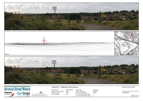
Viewpoint 1 - Giltbrook, Acorn Avenue
Viewpoint 1 - Giltbrook, Acorn Avenue
Viewpoint 1 - Giltbrook, Acorn Avenue
- No tags were found...

You also want an ePaper? Increase the reach of your titles
YUMPU automatically turns print PDFs into web optimized ePapers that Google loves.
Baseline PhotographWireframe0 0.5km 1kmPhotomontage<strong>Viewpoint</strong> 2 - Public Footpath South of Newthorpe CommonOS Reference: 447141 345857Distance to nearest Turbine: 1211mDirection from Site:North<strong>Viewpoint</strong> Height:95mAngle of View:90 DegreesDate of Photograph: 28.09.09Correct Viewing Distance:250mmNo. of Tips Theorectically Visible: 1No. of Hubs Theorectically Visible: 1Newthorpe Wind TurbineVisualisationsFigure 10.15aOS Height date: Reproduced from Ordnance Survey digital map data Crown copyright 2008. All rights reserved. License number 0100031673.
Baseline PhotographWireframe0 0.5km 1kmPhotomontage<strong>Viewpoint</strong> 3 - Robin Hood Way, North of KimberleyOS Reference: 449084 345728Distance to nearest Turbine: 2129mDirection from Site:East<strong>Viewpoint</strong> Height:107mAngle of View:90 DegreesDate of Photograph: 13.07.09Correct Viewing Distance:250mmNo. of Tips Theorectically Visible: 1No. of Hubs Theorectically Visible: 1Newthorpe Wind TurbineVisualisationsFigure 10.16aOS Height date: Reproduced from Ordnance Survey digital map data Crown copyright 2008. All rights reserved. License number 0100031673.
<strong>Viewpoint</strong> 3 - Robin Hood Way, North of Kimberley - EnlargementOS Reference: 449084 345728Distance to nearest Turbine: 2129mDirection from Site:East<strong>Viewpoint</strong> Height:107mAngle of View:45 DegreesDate of Photograph: 13.07.09Newthorpe Wind TurbineCorrect Viewing Distance:500mmVisualisationsNo. of Tips Theorectically Visible: 1No. of Hubs Theorectically Visible: 1 Figure 10.16bOS Height date: Reproduced from Ordnance Survey digital map data Crown copyright 2008. All rights reserved. License number 0100031673.
Baseline PhotographWireframe0 0.5km 1kmPhotomontage<strong>Viewpoint</strong> 4 - KimberleyOS Reference: 449266 345105Distance to nearest Turbine: 2068mDirection from Site:East<strong>Viewpoint</strong> Height:105mAngle of View:90 DegreesDate of Photograph: 28.09.09Correct Viewing Distance:250mmNo. of Tips Theorectically Visible: 1No. of Hubs Theorectically Visible: 1Newthorpe Wind TurbineVisualisationsFigure 10.17aOS Height date: Reproduced from Ordnance Survey digital map data Crown copyright 2008. All rights reserved. License number 0100031673.
<strong>Viewpoint</strong> 4 - Kimberley - EnlargementOS Reference: 449266 345105Distance to nearest Turbine: 2068mDirection from Site:East<strong>Viewpoint</strong> Height:105mAngle of View:45 DegreesDate of Photograph: 28.09.09Newthorpe Wind TurbineCorrect Viewing Distance:500mmVisualisationsNo. of Tips Theorectically Visible: 1No. of Hubs Theorectically Visible: 1 Figure 10.17bOS Height date: Reproduced from Ordnance Survey digital map data Crown copyright 2008. All rights reserved. License number 0100031673.
Baseline PhotographWireframe0 0.5km 1kmPhotomontage<strong>Viewpoint</strong> 5 - A6096 North of AwsworthOS Reference: 448240 344496Distance to nearest Turbine: 1003mDirection from Site:East<strong>Viewpoint</strong> Height:69mAngle of View:90 DegreesDate of Photograph: 13.07.09Correct Viewing Distance:250mmNo. of Tips Theorectically Visible: 1No. of Hubs Theorectically Visible: 1Newthorpe Wind TurbineVisualisationsFigure 10.18aOS Height date: Reproduced from Ordnance Survey digital map data Crown copyright 2008. All rights reserved. License number 0100031673.
<strong>Viewpoint</strong> 5 - A6096 North of Awsworth - EnlargementOS Reference: 448240 344496Distance to nearest Turbine: 1003mDirection from Site:East<strong>Viewpoint</strong> Height:69mAngle of View:45 DegreesDate of Photograph: 13.07.09Newthorpe Wind TurbineCorrect Viewing Distance:500mmVisualisationsNo. of Tips Theorectically Visible: 1No. of Hubs Theorectically Visible: 1 Figure 10.18bOS Height date: Reproduced from Ordnance Survey digital map data Crown copyright 2008. All rights reserved. License number 0100031673.
Baseline PhotographWireframe0 0.5km 1kmPhotomontage<strong>Viewpoint</strong> 6 - Awsworth, Barlow DriveOS Reference: 447997 343890Distance to nearest Turbine: 1067mDirection from Site:Southeast<strong>Viewpoint</strong> Height:86mAngle of View:90 DegreesDate of Photograph: 28.09.09Correct Viewing Distance:250mmNo. of Tips Theorectically Visible: 1No. of Hubs Theorectically Visible: 1Newthorpe Wind TurbineVisualisationsFigure 10.19aOS Height date: Reproduced from Ordnance Survey digital map data Crown copyright 2008. All rights reserved. License number 0100031673.
<strong>Viewpoint</strong> 6 - Awsworth, Barlow Drive - EnlargementOS Reference: 447997 343890Distance to nearest Turbine: 1067mDirection from Site:Southeast<strong>Viewpoint</strong> Height:86mAngle of View:45 DegreesDate of Photograph: 28.09.09Newthorpe Wind TurbineCorrect Viewing Distance:500mmVisualisationsNo. of Tips Theorectically Visible: 1No. of Hubs Theorectically Visible: 1 Figure 10.19bOS Height date: Reproduced from Ordnance Survey digital map data Crown copyright 2008. All rights reserved. License number 0100031673.
Baseline PhotographWireframe0 0.5km 1kmPhotomontage<strong>Viewpoint</strong> 7 - Awsworth Road, River Erewash BridgeOS Reference: 447426 343402Distance to nearest Turbine: 1260mDirection from Site:South<strong>Viewpoint</strong> Height:50mAngle of View:90 DegreesDate of Photograph: 28.09.09Correct Viewing Distance:250mmNo. of Tips Theorectically Visible: 1No. of Hubs Theorectically Visible: 1Newthorpe Wind TurbineVisualisationsFigure 10.20aOS Height date: Reproduced from Ordnance Survey digital map data Crown copyright 2008. All rights reserved. License number 0100031673.
<strong>Viewpoint</strong> 7 - Awsworth Road, River Erewash Bridge - EnlargementOS Reference: 447426 343402Distance to nearest Turbine: 1260mDirection from Site:South<strong>Viewpoint</strong> Height:50mAngle of View:45 DegreesDate of Photograph: 28.09.09Newthorpe Wind TurbineCorrect Viewing Distance:500mmVisualisationsNo. of Tips Theorectically Visible: 1No. of Hubs Theorectically Visible: 1 Figure 10.20bOS Height date: Reproduced from Ordnance Survey digital map data Crown copyright 2008. All rights reserved. License number 0100031673.
Baseline PhotographWireframe0 0.5km 1kmPhotomontage<strong>Viewpoint</strong> 8 - Cotmanhay RoundaboutOS Reference: 446542 343927Distance to nearest Turbine: 1010mDirection from Site:Southwest<strong>Viewpoint</strong> Height:64mAngle of View:90 DegreesDate of Photograph: 13.07.09Correct Viewing Distance:250mmNo. of Tips Theorectically Visible: 1No. of Hubs Theorectically Visible: 1Newthorpe Wind TurbineVisualisationsFigure 10.21aOS Height date: Reproduced from Ordnance Survey digital map data Crown copyright 2008. All rights reserved. License number 0100031673.
<strong>Viewpoint</strong> 8 - Cotmanhay Roundabout - EnlargementOS Reference: 446542 343927Distance to nearest Turbine: 1010mDirection from Site:Southwest<strong>Viewpoint</strong> Height:64mAngle of View:45 DegreesDate of Photograph: 13.07.09Newthorpe Wind TurbineCorrect Viewing Distance:500mmVisualisationsNo. of Tips Theorectically Visible: 1No. of Hubs Theorectically Visible: 1 Figure 10.21bOS Height date: Reproduced from Ordnance Survey digital map data Crown copyright 2008. All rights reserved. License number 0100031673.
Baseline PhotographWireframe0 0.5km 1kmPhotomontage<strong>Viewpoint</strong> 9 - Cotmanhay Playing FieldsOS Reference: 446661 344400Distance to nearest Turbine: 638mDirection from Site:Northwest<strong>Viewpoint</strong> Height:60mAngle of View:90 DegreesDate of Photograph: 28.09.09Correct Viewing Distance:250mmNo. of Tips Theorectically Visible: 1No. of Hubs Theorectically Visible: 1Newthorpe Wind TurbineVisualisationsFigure 10.22aOS Height date: Reproduced from Ordnance Survey digital map data Crown copyright 2008. All rights reserved. License number 0100031673.
<strong>Viewpoint</strong> 9 - Cotmanhay Playing Fields - EnlargementOS Reference: 446661 344400Distance to nearest Turbine: 638mDirection from Site:Northwest<strong>Viewpoint</strong> Height:60mAngle of View:45 DegreesDate of Photograph: 28.09.09Newthorpe Wind TurbineCorrect Viewing Distance:500mmVisualisationsNo. of Tips Theorectically Visible: 1No. of Hubs Theorectically Visible: 1 Figure 10.22bOS Height date: Reproduced from Ordnance Survey digital map data Crown copyright 2008. All rights reserved. License number 0100031673.
Baseline PhotographWireframe0 0.5km 1kmPhotomontage<strong>Viewpoint</strong> 10 - Shipley GateOS Reference: 446192 346272Distance to nearest Turbine: 1225mDirection from Site:Northwest<strong>Viewpoint</strong> Height:56mAngle of View:90 DegreesDate of Photograph: 28.09.09Correct Viewing Distance:250mmNo. of Tips Theorectically Visible: 1No. of Hubs Theorectically Visible: 1Newthorpe Wind TurbineVisualisationsFigure 10.23aOS Height date: Reproduced from Ordnance Survey digital map data Crown copyright 2008. All rights reserved. License number 0100031673.
<strong>Viewpoint</strong> 10 - Shipley Gate - EnlargementOS Reference: 446192 345272Distance to nearest Turbine: 1225mDirection from Site:Northwest<strong>Viewpoint</strong> Height:56mAngle of View:45 DegreesDate of Photograph: 13.07.09Newthorpe Wind TurbineCorrect Viewing Distance:500mmVisualisationsNo. of Tips Theorectically Visible: 1No. of Hubs Theorectically Visible: 1 Figure 10.23bOS Height date: Reproduced from Ordnance Survey digital map data Crown copyright 2008. All rights reserved. License number 0100031673.
Baseline PhotographWireframe0 0.5km 1kmPhotomontage<strong>Viewpoint</strong> 11 - Erewash Canal LocksOS Reference: 446044 345838Distance to nearest Turbine: 1691mDirection from Site:Northwest<strong>Viewpoint</strong> Height:60mAngle of View:90 DegreesDate of Photograph: 28.09.09Correct Viewing Distance:250mmNo. of Tips Theorectically Visible: 1No. of Hubs Theorectically Visible: 1Newthorpe Wind TurbineVisualisationsFigure 10.24aOS Height date: Reproduced from Ordnance Survey digital map data Crown copyright 2008. All rights reserved. License number 0100031673.
<strong>Viewpoint</strong> 11 - Erewash Canal Locks - EnlargementOS Reference: 446044 345838Distance to nearest Turbine: 1691mDirection from Site:Northwest<strong>Viewpoint</strong> Height:60mAngle of View:45 DegreesDate of Photograph: 28.09.09Newthorpe Wind TurbineCorrect Viewing Distance:500mmVisualisationsNo. of Tips Theorectically Visible: 1No. of Hubs Theorectically Visible: 1 Figure 10.24bOS Height date: Reproduced from Ordnance Survey digital map data Crown copyright 2008. All rights reserved. License number 0100031673.
Baseline PhotographWireframe0 0.5km 1kmPhotomontage<strong>Viewpoint</strong> 12 - Babbington Swingate FootpathOS Reference: 449645 343475Distance to nearest Turbine: 2669mDirection from Site:Southeast<strong>Viewpoint</strong> Height:122mAngle of View:90 DegreesDate of Photograph: 28.09.09Correct Viewing Distance:250mmNo. of Tips Theorectically Visible: 1No. of Hubs Theorectically Visible: 1Newthorpe Wind TurbineVisualisationsFigure 10.25aOS Height date: Reproduced from Ordnance Survey digital map data Crown copyright 2008. All rights reserved. License number 0100031673.
<strong>Viewpoint</strong> 12 - Babbington Swingate Footpath - EnlargementOS Reference: 449645 343475Distance to nearest Turbine: 2669mDirection from Site:Southeast<strong>Viewpoint</strong> Height:122mAngle of View:45 DegreesDate of Photograph: 28.09.09Correct Viewing Distance:500mmNo. of Tips Theorectically Visible: 1No. of Hubs Theorectically Visible: 1Newthorpe Wind TurbineVisualisationsFigure 10.25bOS Height date: Reproduced from Ordnance Survey digital map data Crown copyright 2008. All rights reserved. License number 0100031673.
Baseline PhotographWireframe0 0.5km 1kmPhotomontage<strong>Viewpoint</strong> 13 - Greasley ChurchOS Reference: 448911 347147Distance to nearest Turbine: 3000mDirection from Site:Northeast<strong>Viewpoint</strong> Height:110mAngle of View:90 DegreesDate of Photograph: 28.09.09Correct Viewing Distance:250mmNo. of Tips Theorectically Visible: 1No. of Hubs Theorectically Visible: 1Newthorpe Wind TurbineVisualisationsFigure 10.26aOS Height date: Reproduced from Ordnance Survey digital map data Crown copyright 2008. All rights reserved. License number 0100031673.
<strong>Viewpoint</strong> 13 - Greasley Church - EnlargementOS Reference: 448911 347147Distance to nearest Turbine: 3000mDirection from Site:Northeast<strong>Viewpoint</strong> Height:110mAngle of View:45 DegreesDate of Photograph: 28.09.09Newthorpe Wind TurbineCorrect Viewing Distance:500mmVisualisationsNo. of Tips Theorectically Visible: 1No. of Hubs Theorectically Visible: 1 Figure 10.26bOS Height date: Reproduced from Ordnance Survey digital map data Crown copyright 2008. All rights reserved. License number 0100031673.
Baseline PhotographWireframe0 0.5km 1kmPhotomontage<strong>Viewpoint</strong> 14 - Shipley Country ParkOS Reference: 444192 344425Distance to nearest Turbine: 3064mDirection from Site:West<strong>Viewpoint</strong> Height:86mAngle of View:90 DegreesDate of Photograph: 28.09.09Correct Viewing Distance:250mmNo. of Tips Theorectically Visible: 1No. of Hubs Theorectically Visible: 1Newthorpe Wind TurbineVisualisationsFigure 10.27aOS Height date: Reproduced from Ordnance Survey digital map data Crown copyright 2008. All rights reserved. License number 0100031673.
<strong>Viewpoint</strong> 14 - Shipley Country Park - EnlargementOS Reference: 444192 344425Distance to nearest Turbine: 3064mDirection from Site:West<strong>Viewpoint</strong> Height:86mAngle of View:45 DegreesDate of Photograph: 28.09.09Newthorpe Wind TurbineCorrect Viewing Distance:500mmVisualisationsNo. of Tips Theorectically Visible: 1No. of Hubs Theorectically Visible: 1 Figure 10.27bOS Height date: Reproduced from Ordnance Survey digital map data Crown copyright 2008. All rights reserved. License number 0100031673.
Baseline PhotographWireframe0 0.5km 1kmPhotomontage<strong>Viewpoint</strong> 15 - Bestwood Country ParkOS Reference: 455451 346922Distance to nearest Turbine: 8511mDirection from Site:East<strong>Viewpoint</strong> Height:104mAngle of View:90 DegreesDate of Photograph: 28.09.09Correct Viewing Distance:250mmNo. of Tips Theorectically Visible: 1No. of Hubs Theorectically Visible: 1Newthorpe Wind TurbineVisualisationsFigure 10.28aOS Height date: Reproduced from Ordnance Survey digital map data Crown copyright 2008. All rights reserved. License number 0100031673.
<strong>Viewpoint</strong> 15 - Bestwood Country Park - EnlargementOS Reference: 455451 346922Distance to nearest Turbine: 8511mDirection from Site:East<strong>Viewpoint</strong> Height:104mAngle of View:45 DegreesDate of Photograph: 28.09.09Newthorpe Wind TurbineCorrect Viewing Distance:500mmVisualisationsNo. of Tips Theorectically Visible: 1No. of Hubs Theorectically Visible: 1 Figure 10.28bOS Height date: Reproduced from Ordnance Survey digital map data Crown copyright 2008. All rights reserved. License number 0100031673.
Baseline PhotographWireframe0 0.5km 1kmPhotomontage<strong>Viewpoint</strong> 16 - BrinsleyOS Reference: 446410 349457Distance to nearest Turbine: 4879mDirection from Site:North<strong>Viewpoint</strong> Height:100mAngle of View:90 DegreesDate of Photograph: 28.09.09Correct Viewing Distance:250mmNo. of Tips Theorectically Visible: 1No. of Hubs Theorectically Visible: 1Newthorpe Wind TurbineVisualisationsFigure 10.29OS Height date: Reproduced from Ordnance Survey digital map data Crown copyright 2008. All rights reserved. License number 0100031673.
Baseline PhotographWireframe0 0.5km 1kmPhotomontage<strong>Viewpoint</strong> 17 - Bramcote ReservoirOS Reference: 450635 337456Distance to nearest Turbine: 7951mDirection from Site:Southeast<strong>Viewpoint</strong> Height:92mAngle of View:90 DegreesDate of Photograph: 28.09.09Correct Viewing Distance:250mmNo. of Tips Theorectically Visible: 1No. of Hubs Theorectically Visible: 1Newthorpe Wind TurbineVisualisationsFigure 10.30OS Height date: Reproduced from Ordnance Survey digital map data Crown copyright 2008. All rights reserved. License number 0100031673.