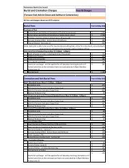
to 64 - Palmerston North City Council
to 64 - Palmerston North City Council
to 64 - Palmerston North City Council
- No tags were found...

You also want an ePaper? Increase the reach of your titles
YUMPU automatically turns print PDFs into web optimized ePapers that Google loves.
Church Street Connec<strong>to</strong>rThe connections from Church Street <strong>to</strong> adjoining mid-blocklinks, open spaces and buildings will influence the outcome forthis East-West Connec<strong>to</strong>r.This presents an opportunity <strong>to</strong> create a sequence of differentspaces and places stretching East <strong>to</strong> West across the Southernside of the city centre. For example, the section of ChurchStreet along the edge of The Square can be reconfigured as a‘Place’ focussed street, providing for further connectionsbetween the buildings, footpaths and The Square.The old Railway Land open space also plays an important rolein this East-West connec<strong>to</strong>r. The vegetation, footpath treatmentand street furnishing should also aim connect Church Street <strong>to</strong>this significant area of open space within the city centre.Strategic Development sites 4 and 5 are positioned along theCook Street connec<strong>to</strong>r. Future developments on these sitesplay an important role in this connec<strong>to</strong>r.<strong>North</strong>ern Connec<strong>to</strong>rRangitikei Street plays an important role for people travellingin and out of the city centre from the <strong>North</strong> and from theAirport via JFK Drive and Airport Drive. The street links StateHighway 3 <strong>to</strong> the city centre.Views <strong>to</strong>ward the city centre are dominant along this route asyou approach the city travelling from the <strong>North</strong>. These viewshelp visi<strong>to</strong>rs orientate themselves as they approach the citycentre. The Clock Tower (and lighting at night) in particular is akey signal. View <strong>to</strong>wards the Clock Tower from Rangitikei Streetshould be enhanced and protected <strong>to</strong> ensure that visualconnections <strong>to</strong>ward the city centre remain.The CCF proposes that the section of Rangitikei Street betweenFeathers<strong>to</strong>n Street and the Ring Road will be a ‘Movement’focussed street, allowing for through movement in<strong>to</strong> and ou<strong>to</strong>f the city centre.The section Rangitikei Street between the Ring Road and KingStreet is proposed <strong>to</strong> be focussed on both Movement andPlace, enhancing the sequence of arrival in<strong>to</strong> the city centre.The most significant transformation for this <strong>North</strong>ernConnec<strong>to</strong>r is reconfiguring Rangitikei Street between KingStreet and the Square <strong>to</strong> become a ‘place’ focussed streetdirectly connecting in<strong>to</strong> the King Street, Cuba Street andThe Square.<strong>North</strong>/South ViewFitzherbert Avenue is one of the key Avenues in<strong>to</strong> the citycentre from the South, the bridge over the Manawatū Riverand the Massey University’s Manawatū Campus. Views <strong>to</strong>wardsthe Square (in particular the Clock Tower) from alongFitzherbert Avenue help <strong>to</strong> enhance the experience of arrivingin<strong>to</strong> the city centre and are an important part of how peopleconnect with the city centre travelling in from the South.The <strong>North</strong>ern section of Fitzherbert Avenue is proposed <strong>to</strong>become a ‘place’ focused street, with a reduction of vehiculardominated environment, increase of active frontage andadditional trees and vegetation. This shift in visual characterwill help create a vibrant and distinctive gateway andconnection on this Southern side <strong>to</strong> the city centre.Strategic Development site 3 is positioned along FitzherbertAvenue. Future development of this site plays an importantrole in this connec<strong>to</strong>r.The Ring RoadEnhancing the character and function of the Ring Road willhelp with both <strong>North</strong>-South and East-West connectionsbypassing the need <strong>to</strong> go through the city centre.The Ring Road consists of 3.4 kilometres of movement street,providing vehicles, cyclists and people a clear route around thecity centre travelling East <strong>to</strong> West, West <strong>to</strong> East, <strong>North</strong> <strong>to</strong> Southand South <strong>to</strong> <strong>North</strong>.The general character of the Ring Road consists of 4 lanes oftraffic, cycling facilities and trees planted in a centralmedian strip.Three of the East-West connec<strong>to</strong>rs that straddle the Ring Roadhave a significant influence on how the city centre Street andOpen Network functions. These are Cuba Street, and itspotential linear park, Main Street West, and the link betweenthe railway land and Te Manawa, and Church Street stretchingeast <strong>to</strong> west across the southern side of the city centre.Intersections between these connec<strong>to</strong>rs and the Ring Roadshould give priority (visual and physical) <strong>to</strong> pedestriansover vehicles.27DRAFT CCF FOR PALMERSTON NORTH key directions [ kd 2 connec<strong>to</strong>rs ]Strategic Development site 1 is positioned on the corner ofRangitikei Street and the Ring Road. Future development ofthis corner plays an important role in this <strong>North</strong>ern connec<strong>to</strong>r.Fitzherbert Avenue