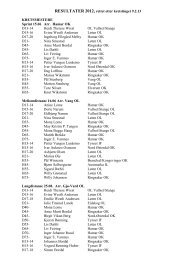
Rules for the Orienteering event in - International Orienteering ...
Rules for the Orienteering event in - International Orienteering ...
Rules for the Orienteering event in - International Orienteering ...

Create successful ePaper yourself
Turn your PDF publications into a flip-book with our unique Google optimized e-Paper software.
3.5.3 The control flagThe control equipment must be <strong>in</strong> accordance with <strong>the</strong> rules <strong>for</strong> IOF <strong>event</strong>s.As far as possible, a control flag should be placed <strong>in</strong> such a manner thatcompetitors first see it only when <strong>the</strong>y have reached <strong>the</strong> described controlfeature. For fairness, <strong>the</strong> visibility of <strong>the</strong> control should be <strong>the</strong> same whe<strong>the</strong>ror not <strong>the</strong>re is a competitor at <strong>the</strong> control site. On no account should <strong>the</strong>control flag be hidden: when competitors reach <strong>the</strong> control <strong>the</strong>y should nothave to search <strong>for</strong> <strong>the</strong> flag.3.5.4 Fairness of control sitesIt is necessary to choose control sites with great care and notably to avoid <strong>the</strong>‘acute angle’ effect where <strong>in</strong>com<strong>in</strong>g competitors can be led <strong>in</strong>to <strong>the</strong> controlby outgo<strong>in</strong>g runners.3.5.5 Proximity of controlsControls on different courses placed too close to one ano<strong>the</strong>r can misleadrunners who have navigated correctly to <strong>the</strong> control site. Accord<strong>in</strong>g to Rule19.4, controls shall not be sited with<strong>in</strong> 30 metres of each o<strong>the</strong>r (15 metres <strong>for</strong>map scales 1:5000 or 1:4000). Only when <strong>the</strong> control features are dist<strong>in</strong>ctlydifferent <strong>in</strong> <strong>the</strong> terra<strong>in</strong> as well as on <strong>the</strong> map, should controls be placed closerthan 60 metres (30 metres <strong>for</strong> map scales 1:5000 or 1:4000).3.5.6 The control descriptionThe position of <strong>the</strong> control with respect to <strong>the</strong> feature shown on <strong>the</strong> map isdef<strong>in</strong>ed by <strong>the</strong> control description.The exact control feature on <strong>the</strong> ground, and <strong>the</strong> po<strong>in</strong>t marked on <strong>the</strong> map,must be <strong>in</strong>disputable. Controls which cannot be clearly and easily def<strong>in</strong>ed by<strong>the</strong> IOF control symbols are usually not suitable and should be avoided.3.6 The f<strong>in</strong>ishAt least <strong>the</strong> last part of <strong>the</strong> route to <strong>the</strong> f<strong>in</strong>ish l<strong>in</strong>e should be a compulsory markedroute.3.7 The elements of map-read<strong>in</strong>gOn a good orienteer<strong>in</strong>g course, competitors are <strong>for</strong>ced to concentrate on navigationthroughout <strong>the</strong> race. Sections requir<strong>in</strong>g no map-read<strong>in</strong>g or attention to navigationshould be avoided unless <strong>the</strong>y result from particularly good route choices.3.8 Route choicesAlternative routes <strong>for</strong>ce competitors to use <strong>the</strong> map to assess <strong>the</strong> terra<strong>in</strong> and to drawconclusions from it. Route choices make competitors th<strong>in</strong>k <strong>in</strong>dependently and willsplit up <strong>the</strong> field, thus m<strong>in</strong>imis<strong>in</strong>g ‘follow<strong>in</strong>g’.3.9 The degree of difficultyFor any terra<strong>in</strong> and map, a course planner can plan courses with a wide range ofdifficulty. The degree of difficulty of <strong>the</strong> legs can be varied by mak<strong>in</strong>g <strong>the</strong>m followl<strong>in</strong>e features more or less closely.Competitors should be able to assess <strong>the</strong> degree of difficulty of <strong>the</strong> approach to acontrol from <strong>the</strong> <strong>in</strong><strong>for</strong>mation available on <strong>the</strong> map, and so choose <strong>the</strong> appropriatetechnique.Attention should be paid to <strong>the</strong> competitors’ expected skill, experience and ability toread or understand <strong>the</strong> f<strong>in</strong>e detail of <strong>the</strong> map. It is particularly important to get <strong>the</strong>level of difficulty right when plann<strong>in</strong>g courses <strong>for</strong> novices and children.3.10 Competition typesCourse plann<strong>in</strong>g must account <strong>for</strong> specific requirements of <strong>the</strong> type of competitionPage 32 IOF Foot <strong>Orienteer<strong>in</strong>g</strong> Competition <strong>Rules</strong> 2013