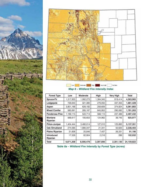
Map 8 – Wildland Fire Intensity Index<strong>Forest</strong> Type Low Moderate High Very High TotalSpruce-Fir 1,317,933 1,062,273 1,364,345 819,414 4,563,965Lodgepole 726,643 321,380 276,050 337,355 1,661,428Aspen 3,801,168 626,182 259,609 374,924 5,061,883Mixed Conifer 560,061 285,167 645,953 290,082 1,781,263Ponderosa Pine 1,169,115 522,714 568,113 237,489 2,497,432Montane568,617 193,653 124,962 38,745 925,977RiparianPiñon-Juniper 1,404,444 3,480,014 127,010 125,883 5,137,351Oak Shrubland 274,095 1,990,347 21,341 50,620 2,336,403Plains Riparian 31,606 25,846 7,407 26,331 91,190Introduced17,526 82,904 2,216 286 102,932RiparianTotal 9,871,208 8,590,478 3,397,006 2,301,130 24,159,822Table 8a – Wildland Fire Intensity by <strong>Forest</strong> Type (acres)30
Owner Low Moderate High Very High TotalUSFS 5,280,057 2,307,319 2,250,772 1,452,260 11,290,408BLM 1,253,727 2,497,214 292,158 207,293 4,250,392NPS 121,213 155,075 67,342 44,516 388,146USFWS 4,514 4,818 812 1,868 12,012DOD 6,337 40,652 1,572 530 49,090Federal-Other 2,906 3,588 242 251 6,988State 205,547 246,158 68,199 46,441 566,346Tribal 216,527 155,285 14,965 15,483 402,259Local Govt. 61,329 36,987 33,231 22,757 154,304Private 2,718,381 3,142,656 667,532 509,589 7,038,158Total 9,870,538 8,589,752 3,396,824 2,300,988 24,158,103Table 8b – Wildfire Intensity by <strong>Forest</strong> Ownership/Management (acres)Data Gaps• Need consistent fi re reporting data for all jurisdictions across the state.• Need updated LANDFIRE data on the current condition of <strong>Colorado</strong>’slodgepole pine forests.• Need a fuel model to help predict fi re behavior in the canopy of deadlodgepole pine forests.• Need a fi re susceptibility analysis for the Eastern Plains.Identify, Manage and Reduce Threats to <strong>Forest</strong> andEcosystem HealthIn addition to fi re, insects and disease, invasive species and climate changealso can cause unwanted impacts in <strong>Colorado</strong>’s forests. Although manyinsects and diseases are native to the state, underlying forest conditionscombined with climatic factors can cause them to operate at an intensity orscale that causes concern. Noxious weeds, such as tamarisk, cheat grassor meadow knapweed, however, are not native to <strong>Colorado</strong>’s forests andtheir presence serves to displace native species, alter hydrologic regimes,increase wildfi re risk and cause other damage within the ecosystem. Althoughthe extent of future climate change impacts is unknown, current trendsindicate the possibility for increased susceptibility to fi re, insects and disease,decreased forest cover at lower elevations and loss of habitat for some forestdependentspecies.Insect and Disease Overview: A number of insects and diseases regularlyimpact the condition of <strong>Colorado</strong>’s forests. Some are exotic, or introduced,but most are native and always present at endemic levels.Natural cycles of insect and disease activity are an important component ofa functioning forest ecosystem because they contribute to the diversity ofsizes, age classes and species types across the forest landscape. <strong>Forest</strong>insects also provide food for wildlife and their activities can result in nesting,roosting and hunting sites for birds and other animals. They also can createoccasional small openings that increase growth of understory grasses andforbs. Insects of primary concern in <strong>Colorado</strong> include the mountain pinebeetle, spruce beetle, piñon ips beetle, western spruce budworm and balsambark beetle. Diseases of concern include dwarf mistletoe and armillaria root31
- Page 1 and 2: Colorado Statewide ForestResource A
- Page 3: Table of ContentsI. Executive Summa
- Page 6 and 7: II.BackgroundThe Colorado Statewide
- Page 8 and 9: National Guidance for Statewide For
- Page 10 and 11: III. Overview of Colorado’s Fores
- Page 12 and 13: Spruce-Fir 9Spruce-fi r is among th
- Page 14 and 15: Mixed Conifer 14The mixed conifer f
- Page 16 and 17: Oak ShrublandsOak shrublands cover
- Page 18 and 19: Windbreaks, shelterbelts and their
- Page 20 and 21: Owner Spruce-Fir Lodgepole Aspen Mi
- Page 22 and 23: forest management costs per acre ha
- Page 24 and 25: include standard ownership data and
- Page 26 and 27: The second metric is an estimate of
- Page 28 and 29: Map 4 - Colorado Forest Legacy Area
- Page 30 and 31: NATIONAL THEME: Protect Forests fro
- Page 32 and 33: Map 7 - Wildland Fire Susceptibilit
- Page 36 and 37: ot (CSFS 2001 and 2002). Some insec
- Page 38 and 39: Map 10 - Insect and Disease Mitigat
- Page 40 and 41: is legally mandated, as well as dal
- Page 42 and 43: change, including species extinctio
- Page 44 and 45: transport of materi als that can ad
- Page 46 and 47: Map 15 - Post-Fire Erosion RiskMap
- Page 48 and 49: environment, many homes and other s
- Page 50 and 51: Owner 0.5 mile 1 mile 2 mile TotalU
- Page 52 and 53: Map 18 - Wildland-Urban Interface w
- Page 54 and 55: Map 20 - Wildland-Urban Interface w
- Page 56 and 57: They also are important partners in
- Page 58 and 59: Forest TypeAcres for Wood Products
- Page 60 and 61: of fragmentation to help forest man
- Page 62 and 63: Forest Type Low Moderate High Very
- Page 64 and 65: Map 25 - Important Habitat for Econ
- Page 66 and 67: ACRESImp. Habitat for Econ.Imp. Spe
- Page 68 and 69: Forest Type Low Moderate High Very
- Page 70 and 71: Map 28 - Community Forestry Opportu
- Page 72 and 73: Enhance Public Benefits from Trees
- Page 78 and 79: VI. ReferencesAlexander, K. [Intern
- Page 80 and 81: Neely, B., Comer, P., Moritz, C., L
- Page 82 and 83: VII. Statewide Assessment Steering
- Page 84 and 85:
APPENDIX A - Colorado Statewide For
- Page 86 and 87:
• Identify and conserve high prio
- Page 88 and 89:
assessments and resource strategies
- Page 90 and 91:
National Theme: Protect Forests fro
- Page 92 and 93:
Protect, conserve, and enhance wild
- Page 94:
States are encouraged to draw from