- Page 1 and 2: JACKSONVILLE HARBOR NAVIGATION STUD
- Page 3 and 4: EXECUTIVE SUMMARY INTEGRATED GENERA
- Page 5 and 6: FIGURE 1: JACKSONVILLE HARBOR STUDY
- Page 7 and 8: Coordination with Agencies and the
- Page 9 and 10: DRAFTINTEGRATED GENERAL REEVALUATIO
- Page 11 and 12: 4.6 DECISIONS TO BE MADE...........
- Page 13 and 14: 7.3.12 Invasive and Exotic Species
- Page 15 and 16: APPENDICES APPENDIX A - ENGINEERING
- Page 17 and 18: Table 37: Cost Sharing Table NED Pl
- Page 19 and 20: Figure 33: View of typical altitude
- Page 21 and 22: 1.0 STUDY INFORMATION*1.1 INTRODUCT
- Page 23 and 24: 1.5 HISTORY OF THE INVESTIGATIONThe
- Page 25 and 26: study was needed for authorization
- Page 27 and 28: 1.7 PLANNING PROCESS AND REPORT ORG
- Page 29 and 30: The local watersheds of the LSJR en
- Page 31 and 32: River MileMiles · App'Jios to both
- Page 33 and 34: Basin Name- Lower St. Johns River-
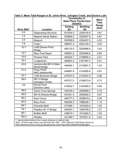
- Page 35: 2.2.3 Tides and SalinityThe St. Joh
- Page 39 and 40: 2.2.5 Sea Level RiseThroughout geol
- Page 41 and 42: groundwater (Sucsy et al., 2012; SJ
- Page 43 and 44: to applicable standards for the mai
- Page 45 and 46: Restoration Strategy” in May 2003
- Page 47 and 48: LegendProject CenterlineC.: Origina
- Page 49 and 50: LegendProject Centerlinelimucuan Pr
- Page 51 and 52: Preserve. An ongoing priority of th
- Page 53 and 54: available at http://www.coj.net/dep
- Page 55 and 56: the Federal Insecticide, Fungicide,
- Page 57 and 58: From the early Colonial period onwa
- Page 59 and 60: •Retail trade - 12.3%;•Transpor
- Page 61 and 62: ecognized populations or management
- Page 63 and 64: 2.3.2.3 Wood StorkWood storks (Myct
- Page 65 and 66: FIGURE 13: WOOD STORK NESTING COLON
- Page 67 and 68: loggerheads. All three takes occurr
- Page 69 and 70: and the number of nests across the
- Page 71 and 72: waters (20 m) of the continental sh
- Page 73 and 74: FIGURE 14: NORTH ATLANTIC RIGHT WHA
- Page 75 and 76: 2.3.3 Essential Fish HabitatThe pro
- Page 77 and 78: Table 10: Prey species that May Occ
- Page 79 and 80: Dial Cordy (2011) described the est
- Page 81 and 82: *(adapted from American Society of
- Page 83 and 84: Table 13: Records of Bird Species f
- Page 85 and 86: 2006-20101994 NE Bartram 2006FL 1
- Page 87 and 88:
Amphibians and ReptilesSouthern Bla
- Page 89 and 90:
2.3.8 Other Wildlife ResourcesFresh
- Page 91 and 92:
2.3.10 Submerged Aquatic Vegetation
- Page 93 and 94:
the Tamarix spp. (salt cedar) and t
- Page 95 and 96:
Common Name Scientific Name Number
- Page 97 and 98:
emove air potatoes from several sit
- Page 99 and 100:
Table 16: Non-native aquatic specie
- Page 101 and 102:
COMMON SCIENTIFIC HABITAT PROBABLE
- Page 103 and 104:
COMMON SCIENTIFIC HABITATPROBABLEDA
- Page 105 and 106:
2.3.14 RecreationRecreational boat
- Page 107 and 108:
Table 17: Port FacilitiesGeneral Na
- Page 109 and 110:
Coal, petroleum products, food & fa
- Page 111 and 112:
Rotterdam, the Netherlands. MOL ter
- Page 113 and 114:
Route GroupFE-ECUS-PAN FE-ECUS-SUEZ
- Page 115 and 116:
Total # Calls 2484 2681 2681 2430 2
- Page 117 and 118:
compared to those of the City of Ja
- Page 119 and 120:
Table 22: Demographic SummaryCensus
- Page 121 and 122:
3.0 FUTURE WITHOUT-PROJECT CONDITIO
- Page 123 and 124:
The future without project conditio
- Page 125 and 126:
• Harbor channel maintenance will
- Page 127 and 128:
construction (Knuuti, 2002)). For e
- Page 129 and 130:
deepening at time of construction b
- Page 131 and 132:
concerns about future expansion of
- Page 133 and 134:
2. Develop an alternative that is e
- Page 135 and 136:
• Identify the plan that most eff
- Page 137 and 138:
In accordance with this policy, alt
- Page 139 and 140:
FIGURE 25: STRUCTURAL MEASURES CUTS
- Page 141 and 142:
Table 29: Structural Measures elimi
- Page 143 and 144:
ERDC ship simulation which took pla
- Page 145 and 146:
Table 31: Comparison of Final Array
- Page 147 and 148:
5.6.1 Deviation from the NED Plan:
- Page 149 and 150:
5.6.1.3 Incremental Costs and Benef
- Page 151 and 152:
ALTERNATIVE ENVIRONMENTALFACTOR44-f
- Page 153 and 154:
ALTERNATIVE ENVIRONMENTALFACTOR44-f
- Page 155 and 156:
ALTERNATIVE ENVIRONMENTALFACTOR44-f
- Page 157 and 158:
An interagency assessment team was
- Page 159 and 160:
Table 35: Schedule for Construction
- Page 161 and 162:
The effect of tides on the river is
- Page 163 and 164:
chisels or spuds onto the rock, cau
- Page 165 and 166:
FIGURE 27: TYPICAL STEMMED HOLE FOR
- Page 167 and 168:
To estimate the maximum poundage of
- Page 169 and 170:
FIGURE 31: BLAST ZONE RADII AND EQU
- Page 171 and 172:
FIGURE 32: TYPICAL OBSERVER HELICOP
- Page 173 and 174:
contractors utilize a small, unconf
- Page 175 and 176:
comfort and the potential damage re
- Page 177 and 178:
• ideal drill pattern for typical
- Page 179 and 180:
ate the technical portion of a cont
- Page 181 and 182:
explored during a subsequent Value
- Page 183 and 184:
6.6 SUMMARY OF ACCOUNTSAs stated in
- Page 185 and 186:
percent Federal responsibility. Tab
- Page 187 and 188:
Table 37: Cost Sharing Table NED Pl
- Page 189 and 190:
The USACE Environmental Operating P