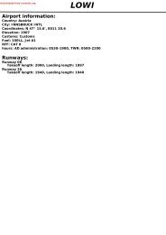
1 LIEO OLBIA/Costa Smeralda
1 LIEO OLBIA/Costa Smeralda
1 LIEO OLBIA/Costa Smeralda
- No tags were found...

You also want an ePaper? Increase the reach of your titles
YUMPU automatically turns print PDFs into web optimized ePapers that Google loves.
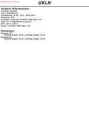
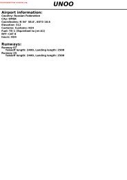
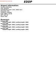
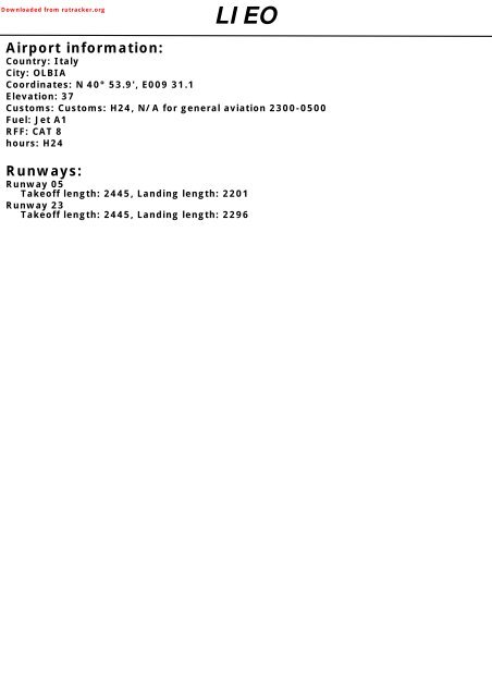
Downloaded from rutracker.org<strong>LIEO</strong>Airport information:Country: ItalyCity: <strong>OLBIA</strong>Coordinates: N 40° 53.9', E009 31.1Elevation: 37Customs: Customs: H24, N/A for general aviation 2300-0500Fuel: Jet A1RFF: CAT 8hours: H24Runways:Runway 05Takeoff length: 2445, Landing length: 2201Runway 23Takeoff length: 2445, Landing length: 2296
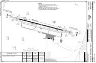
If you like to use this charts, please, buy a subscription for nDAC.For rutracker.orgAERODROME10 - 101 MAY 13Olbia TWR ATIS118.975 113.9121.950AD Elev 37 ARP: N40 53.9 E009 31.1 RFF: CAT 8 AD HR: H24<strong>Costa</strong> <strong>Smeralda</strong>Italy - <strong>LIEO</strong> / OLB<strong>OLBIA</strong>E009 30 E009 311EDTHR CoordinatesRWY 05 N40 53.6 E009 30.5RWY 23 N40 54.2 E009 31.7GA TerminalNDB SMEApron 2HH1F9HSE05054°FireStationCargoTerminalGG1F7F F8DFELEV 36TerminalTWRMELEV 36Apron 1HangarLC2445x45m8022x148ftCApron 3HoldingBay 23 AFBELEV 28234°ELEV 20Intersection TORARWY 05C 849m / 2785ftD 1599m / 5246ftRWY 23B 2078m / 6817ftC 1340m / 4396ftD B0 500 1000mN0 1000 2000 3000 4000ft23N4054VOR/DME SMERWY Slope TORA m/ ft LDA m/ ft ALS REDL RCLL Additional05 - 0.2 2445 / 8022 2201 / 7221 VRB A H 30m P 3.5°L/R (49)23 +0.2 2445 / 8022 2296 / 7533 VRB A 1 H 30m P 3°L/R (52)1 420m.EU OPSRWY05/23TAKE OFF MINIMAFacilitiesRCL (day only) or RCL + REDLNIL (day only)A B C400m500mRVRD400m500mNavtech - lieo01laorg010 - 1Change: COM, Int TORATHIS CHART IS A PART OF NAVIGRAPH CHARTS AND IS INTENDED FOR FLIGHT SIMULATION USE ONLY
If you like to use this charts, please, buy a subscription for nDAC.For rutracker.org10 - 2AERODROME APRON 1Olbia TWR118.975121.950ATIS113.910 - 201 MAY 13Hangar<strong>Costa</strong> <strong>Smeralda</strong>Italy - <strong>LIEO</strong> / OLB<strong>OLBIA</strong>Apron 1ELEV 38Terminal118119Fire StationTWR10110210310410511727116 2523 2821 262422106L115107CargoTerminal114109108FC113112110M111FRWY 05/23Parking position coordinatesNavtech - lieo02laorg0101, 102103104, 105106107, 108109110111, 112113, 114N40 54.1 E009 30.9N40 54.1 E009 31.0N40 54.2 E009 31.0N40 54.1 E009 31.1N40 54.1 E009 31.0N40 54.0 E009 31.0N40 54.0 E009 30.9N40 54.0 E009 30.8N40 54.1 E009 30.8115 N40 54.1 E009 30.921, 22 N40 54.1 E009 31.123-27 N40 54.2 E009 31.228 N40 54.2 E009 31.1116 N40 54.3 E009 31.1117 N40 54.3 E009 31.2118 N40 54.4 E009 31.2119 N40 54.4 E009 31.3Change: COM, Stands, Stand coord, RenumberedTHIS CHART IS A PART OF NAVIGRAPH CHARTS AND IS INTENDED FOR FLIGHT SIMULATION USE ONLY
If you like to use this charts, please, buy a subscription for nDAC.For rutracker.orgGROUND APRON 2 / APRON 3Olbia TWR ATIS118.975 113.9121.950General AviationParking position coordinates201, 202,208, 209N40 53.7 E009 30.3216, 218220, 222203, 204 N40 53.7 E009 30.4224205-207N40 53.7 E009 30.2210-214215, 217 N40 53.8 E009 30.2219 ,221223N40 53.8 E009 30.3225, 226 N40 53.8 E009 30.410 - 301 MAY 13Apron 2ELEV 38217219T221215218213 216211214212209208210 207206202HT 205HSH1H201E220F9223<strong>Costa</strong> <strong>Smeralda</strong>222S203HS225224 226FGT204Italy - <strong>LIEO</strong> / OLBGS G1<strong>OLBIA</strong>F8RWY 05/23F710 - 3Navtech - lieo03gaorg0Parking position coordinates29, 30, 3731-36HB 233940-51N40 54.2 E009 31.4N40 54.2 E009 31.3N40 54.3 E009 31.4N40 54.3 E009 31.4N40 54.3 E009 31.5454443424641474048394951 50HB2337 FN323334353629 3031Apron 3ELEV 37BRWY 05/23AChange: COM, RenumberedTHIS CHART IS A PART OF NAVIGRAPH CHARTS AND IS INTENDED FOR FLIGHT SIMULATION USE ONLY
If you like to use this charts, please, buy a subscription for nDAC.For rutracker.org10 - 4GROUNDOlbia TWR118.975121.950Low Visibility ProceduresATIS113.910 - 401 MAY 131<strong>Costa</strong> <strong>Smeralda</strong>LEGENDArrival routesDeparture routesFollow-me PositionItaly - <strong>LIEO</strong> / OLB<strong>OLBIA</strong>GA TerminalApron 2HH1E1F9HSGFG1F8FireStationCargoTerminalF7DTWRFTerminalM1Apron 1Hangar18022x148ftHoldingBay 23054°234°L2445x45m /CApron 30523NFB1ANavtech - lieo04gaorg0Change: NewTHIS CHART IS A PART OF NAVIGRAPH CHARTS AND IS INTENDED FOR FLIGHT SIMULATION USE ONLY
If you like to use this charts, please, buy a subscription for nDAC.For rutracker.orgGENERAL10 - 5 01 MAY 13Italy - <strong>LIEO</strong> / OLB<strong>Costa</strong> <strong>Smeralda</strong> <strong>OLBIA</strong>lieo05gaorg0© Navtech -GENERAL1. SPEED1.1 Implementation of speed control for radarcontrolled ACFT, if not otherwise instructedby ATC, shall reduce speed to:- 250kt at FL100 or below;- 200kt starting the turn to intercept theLOC or the appropriate radial in caseof VOR RWY 23/05 final approach orthe NDB reading in case of NDB RWY23 final approach, or at a distanceof 12nm from RWY THR in case ofstraight-in approach.- 180kt completing the intercepting turnor at a distance of 8nm from RWYTHR;- 160kt at a distance of 4nm from RWYTHR.1.2 Olbia Radar may request pilots:- To adjust speed in a specific mannerduring the intermediate approach;- Speed adjustment of more than+/-20 kt, if ACFT is established on anintermediate or final approach, to aMNM distance of 4nm from RWY THR.2. NOISE ABATEMENT PROCEDURES2.1 Engine tests prohibited between 22-05.2.2 Use of APU limited to 60min before EBOTand 20min after ATA.2.3 Between 22-05 it is mandatory for landing touse the entire RWY to taxi to apron.3. TWY RESTRICTIONTWY N width is 13m/ 42ft.4. START-UPRequest start-up clearance 5min beforeready to start engines.5 APRON5.1 Follow-me available on request by pilots/ATC.5.2 APRON 1Pilots shall taxi with caution inside the apron1 area, due to portion of apron TWY andservice road not segregated, stands 110and 111 are available for CAT D ACFT,stands 118 and 119 are available forCAT C ACFT.5.3 APRON 2Preferential use of apron TWY-taxi routes:5.3.1 RWY 05 in use(a) DeparturesStand 219, 221, 223, 225:T, HT, HS, IHP H1Stand 211-216 and 218:T, HT, HS, IHP H1Stand 210 and 205:HT, HS, IHP H1Stand 203, 204 and 206-209:S, HS, IHP H1Stand 220, 222, 224, 226:S, HS, IHP H1Stand 217:T3, T, HT, HS, IHP H1 (Pushback)(b) ArrivalsStand 219, 221, 223, 225:G, GS, GT, TStand 211-216 and 218:G, GS, GT, TStand 210:G, GS, GT, TStand 203-209:G, GS, SStand 220, 222, 224, 226:G, GS, GT, TStand 217:G, GS, GT, T5.3.2 RWY 23 in use(a) DeparturesStand 219, 221, 223, 225:T, GT, GS, GStand 211-216 and 218:T, GT, GS, GStand 210 and 205:HS, S, GS, GStand 203, 204 and 206-209:S, GS, GStand 220, 222, 224, 226:S, GS, GStand 217:T3, T, GT, GS, G (Pushback)THIS Change: CHART 1.3, IS 5.2, A PART Renumbered OF NAVIGRAPH CHARTS AND IS INTENDED FOR FLIGHT SIMULATION USE ONLY10 - 5
If you like to use this charts, please, buy a subscription for nDAC.For rutracker.orgGENERAL10 - 6 01 MAY 13Italy - <strong>LIEO</strong> / OLB<strong>Costa</strong> <strong>Smeralda</strong> <strong>OLBIA</strong>10 - 6lieo06gaorg0(b) ArrivalsStand 219, 221, 223, 225:H, HS, HT, TStand 211-216 and 218:H, HS, HT, TStand 210:H, HS, HT, TStand 203-209:G, GS, SStand 220, 222, 224, 226:H, HS, HT, TStand 217:H, HS, HT, TStand 201 and 202 are available for CAT DACFT taxi in procedures only with follow-meservice. Taxi out on self-manoeuvring.5.4 APRON 3The movement of the ACFT inside theapron 3 area, will be one a time. In orderto ensure the safe handling, Follow-me/Marshall assistance is mandatory.5.4.1 Taxi-in/out procedures- Stands 110, 111 via TWY M- Stand 29-37 via TWY N- Stand 39-51 via Holding bay 23(a) DeparturesPilots shall report on the stand taxilaneN/Holding bay 23, ready for taxiing.(b) ArrivalsPilots shall wait for follow-me/marshalling service on the standtaxilane N/Holding bay RWY 23.6. COM FAILWhenever an ACFT, operating inmaneuvering area, experiences COM FAIL,it shall comply with the following:- Departing ACFT: continue strictly onassigned taxi route to the clearancelimit and wait for the arrival offollow-me vehicle in order to be guidedback to the stand.- Arriving ACFT: vacate the RWY andILS sensitive area, via appropriateTWY and wait on the first segment forthe arrival of follow-me vehicle in orderto be guided back to the stand.7. LOW VISIBILITY PROCEDURE7.1 Low visibility procedures will be applied toprecision approach and landing operationsat the following conditions;- RVR is 550m/1804ft or below.- Cloud base height is below 200ftaccording to the meteorological report.- When the rapid deterioration ofweather conditions recommends so.7.2 Pilots will be informed by ATC when LVPare in force.- RWY 05/23 is suitable for ILS CAT Iapproach and landing operations.- RWY 05 is available for operations withRVR equal or less than 1000m/3280ft.- No operations allowed with RVR lessthan 400m/1312ft.7.3 Ground Operations- TWY B, C and D are not available.- Departing ACFT RWY 05:ACFT shall enter the RWY via TWY Eand TWY H, In case of aborted takeoffthe RWY shall be vacated via TWY A.- Arriving ACFT RWY 05:ACFT shall vacate the RWY viaTWY A, report to the TWR when theRWY has been vacated and whenassigned stand has been reached.- Follow me assistance available onrequest and mandatory for all airtaxiing operations on the Apron 2.© Navtech -THIS Change: CHART New IS A PART OF NAVIGRAPH CHARTS AND IS INTENDED FOR FLIGHT SIMULATION USE ONLY
180360If you like to use this charts, please, buy a subscription for nDAC.For rutracker.orgSID RWY 05WEF 30 MAY 13RNAV (By ATC)Olbia TWR APP ATIS118.975 125.95 113.9121.95 122.875TA 6000 AD Elev 3730 - 1 01 MAY 13P-RNAV requiredOLBE5K034°OLBEK 5K<strong>Costa</strong> <strong>Smeralda</strong>BATO5KOLBEKFL100D27.3 SMEN41 15.5E009 51.2BATOX 5K25.5 056°Italy - <strong>LIEO</strong> / OLB<strong>OLBIA</strong>BATOXFL100N41 12.8E010 09.4POZZOFL90MAX 240ktN40 56.8E009 16.0<strong>Smeralda</strong>357 SMEPOZZO 5KPOZO5K10 054°EO6033600D10 SMEN40 59.1E009 40.930 - 1N40 53.6E009 30.1SUKU5K6000MAX 240kt<strong>Smeralda</strong>D113.9 SMEN40 53.4E009 30.1EO607FL100N40 41.5E009 27.818.812187°LABOM 5KLABO5KSUKUN 5K20.5 113°SUKUNFL100N40 45.0E009 54.740187°LABOMN40 22.9E009 24.360SME270520 5 10nmNavtech - lieo01daorg0Scale distortedMNM CLIMB GRADIENT: 7% to 3600.SID Routeing AltitudesINITIAL CLIMB Climb on 054° - EO603 - follow SID.EO603 MNM 3600BATOX 5K BATOX.BATOX MNM FL100LABOM 5K SME (MAX 240kt) - EO607 - LABOM.SME MNM 6000EO607 MNM FL100OLBEK 5K OLBEK.OLBEK MNM FL100POZZO 5K POZZO.POZZO MNM FL90SUKUN 5K SME (MAX 240kt) - SUKUN.SME MNM 6000SUKUN MNM FL100Change: NewTHIS CHART IS A PART OF NAVIGRAPH CHARTS AND IS INTENDED FOR FLIGHT SIMULATION USE ONLY
180360If you like to use this charts, please, buy a subscription for nDAC.For rutracker.orgSID RWY 23WEF 30 MAY 13RNAV (By ATC)Olbia TWR APP ATIS118.975 125.95 113.9121.95 122.875TA 6000 AD Elev 37EO601N41 06.7E009 34.630 - 201 MAY 13P-RNAV requiredOLBE5QOLBEK 5Q15.3<strong>Costa</strong> <strong>Smeralda</strong>27 076°OLBEKFL100Italy - <strong>LIEO</strong> / OLBD27.3 SMEN41 15.5E009 51.2BATOX 5QBATO5Q<strong>OLBIA</strong>BATOXFL100N41 12.8E010 09.430 - 2POZZO 5QFL90POZZON40 56.8E009 16.0MINKAFL90N40 49.2E008 51.3270°MINK5Q20.4MINKA 5QScale distortedPOZZO 5QPOZO5QEO60417.2 054°243°530010D10 SMEN40 49.0E009 18.2<strong>Smeralda</strong>357 SMEN40 53.6E009 30.1<strong>Smeralda</strong>D113.9 SMEN40 53.4E009 30.1200°38144°LABO5QLABOM 5QLABOM 5QEO602FL100N40 58.4E009 42.4SUKUN 5Q26.5SUKU5QSUKUNFL100N40 45.0E009 54.7Navtech - lieo02daorg0MNM CLIMB GRADIENT:LABOMN40 22.9E009 24.3Climb on 243° - EO604 - follow SID.POZZO - EO601 - BATOX.POZZO - EO601 - EO602 - LABOM.MINKA.POZZO - EO601 - OLBEK.POZZO.Scale distorted8.5% to 6000.POZZO - EO601 - SUKUN.5 10nmSID Routeing AltitudesINITIAL CLIMBBATOX 5QLABOM 5QMINKA 5QOLBEK 5QPOZZO 5QSUKUN 5QSMEEO604 MNM 5300BATOX MNM FL100EO602 MNM FL100MINKA MNM FL90OLBEK MNM FL100POZZO MNM FL90SUKUN MNM FL100Change: NewTHIS CHART IS A PART OF NAVIGRAPH CHARTS AND IS INTENDED FOR FLIGHT SIMULATION USE ONLY0604027052
180360If you like to use this charts, please, buy a subscription for nDAC.For rutracker.orgSID RWY 05Olbia TWR APP118.975 125.95121.95 122.875TA 6000 AD Elev 37<strong>Smeralda</strong>357 SMEN40 53.6E009 30.1<strong>Smeralda</strong>D113.9 SMEN40 53.4E009 30.1WEF 30 MAY 135000VOR SME EastD5 SMED4.6 ISMDME191°R011109.9 ISMN40 53.8E009 30.6ATIS113.9SME054°3600D10 SMED9.5 ISMR102113°SUKUN 5ASUKU5A30 - 3OLBEKFL100N41 15.5E009 51.2OLBE5AD12 SME ArcATC01 MAY 13034°OLBEK 5AMILISD113.8ALG054°BATOX 5AN41 02.0E009 46.46000BATO5AR067SUKU5B<strong>Costa</strong> <strong>Smeralda</strong>FL85D31 SMED30.5 ISMSUKUN 5BSUKUNFL100N40 45.0E009 54.75Italy - <strong>LIEO</strong> / OLB<strong>OLBIA</strong>BATOXN41 12.8E010 09.430 - 30 5 10nm60SME4027052MNM CLIMB GRADIENT: 6.9% to 3600.Navtech - lieo03daorg0SID Routeing AltitudesClimb on R054 SME to D10 SME/ D9.5 ISM Cross D10 SME/ D9.5 ISMINITIAL CLIMB- follow SID.MNM 3600BATOX 5AOLBEK 5ASUKUN 5ASUKUN 5B(ATC only)Climb on R054 SME - at D31 SME/ D30.5 ISMturn right - intcp R067 ALG - BATOX.Turn left - intcp R034 SME - OLBEK.Turn left - intcp 191°/R011 SME - at D5 SME/D4.6 ISM turn left - intcp R113 SME - SUKUN.Turn right - D12 SME arc. On crossing R102SME turn left - intcp R113 SME - SUKUN.D31 SME/ D30.5 ISM MNM FL85OLBEK MNM FL100D5 SME/D4.6 ISM MNM 5000SUKUN MNM FL100R102 SME MNM 6000SUKUN MNM FL100Change: COM, Dist, ISM DME, RenumberedTHIS CHART IS A PART OF NAVIGRAPH CHARTS AND IS INTENDED FOR FLIGHT SIMULATION USE ONLY
180360If you like to use this charts, please, buy a subscription for nDAC.For rutracker.orgSID RWY 05WEF 30 MAY 13TA 6000 AD Elev 37VOR SME WestOlbia TWR APP ATIS118.975 125.95 113.9121.95 122.875TEREZFL140FL110N41 20.0E009 02.230 - 401 MAY 13<strong>Costa</strong> <strong>Smeralda</strong>Italy - <strong>LIEO</strong> / OLB<strong>OLBIA</strong>TEREZ 5A/DTERE5A/D30 - 4335°AJOPOZZOFL85N40 56.7E009 16.00 5 10nmD114.8R153TEREZ 5A/5D:FL85TERE5DTERE5ATEREZ 5APOZO6A247°D52ALGTEREZ 5DPOZZO 6A286° ATC<strong>Smeralda</strong>D113.9 SMEN40 53.4E009 30.1R3406000191°R011SME<strong>Smeralda</strong>357 SMEN40 53.6E009 30.15500D3 SMED2.6 ISM054°DME109.9 ISMN40 53.8E009 30.6R0673600D10 SMED9.5 ISM60D113.8ALGSME4027052Navtech - lieo04daorg0MNM CLIMB GRADIENT: 6.9% to 3600.SID Routeing AltitudesINITIALCLIMBPOZZO 6ATEREZ 5ATEREZ 5D(ATC only)Climb on R054 SME to D10 SME/ D9.5 ISM- follow SID.Turn left - intcp 247°/R067 ALG - POZZO.Turn left - intcp 247°/R067 ALG - at R293 SME/R153 AJO turn right - intcp 335°/R155 AJO -TEREZ.Turn left - intcp 191°/R011 SME - at D3 SME/ D2.6ISM turn right - intcp R286 SME inbd to POZZO -at R153 AJO turn right - intcp 335°/R155 AJO -TEREZ.Cross D10 SME/ D9.5 ISMMNM 3600R340 SME MNM 6000POZZO MNM FL85R340 SME MNM 6000R293 SME/R153 AJO MNM FL85TEREZ MNM FL110-140D3 SME/ D2.6 ISM MNM 5500R286 SME/R153 AJO MNM FL85TEREZ MNM FL110-140Change: COM, Dist, ISM DME, RenumberedTHIS CHART IS A PART OF NAVIGRAPH CHARTS AND IS INTENDED FOR FLIGHT SIMULATION USE ONLY
R176180360If you like to use this charts, please, buy a subscription for nDAC.For rutracker.orgSID RWY 05WEF 30 MAY 13VOR SME SouthOlbia TWR APP ATIS118.975 125.95 113.9121.95 122.875TA 6000 AD Elev 3730 - 501 MAY 13<strong>Costa</strong> <strong>Smeralda</strong>Italy - <strong>LIEO</strong> / OLB<strong>OLBIA</strong>Navtech - lieo05daorg0MINKAFL90N40 49.2E008 51.3Scale distortedMINK5APOZZOFL85N40 56.7E009 16.0MINKA 5A0 5 10nmPOZZO 5D261°POZO5DD113.8ALGATC30KOLUSFL100D11 SMEN40 43.1E009 26.5FL100ATC286°D12 SMED12.4 ISMLABO5AD3 SMED2.6 ISMKOLU6AScaledistorted5500194°11191°LABOMN40 22.9E009 24.3<strong>Smeralda</strong>D113.9 SMEN40 53.4E009 30.1VAVAXMNM CLIMB GRADIENT: 6.9% to 3600.SID Routeing AltitudesINITIAL Climb on R054 SME. At D10 SME/ D9.5 ISM Cross D10 SME/ D9.5 ISMCLIMB - follow SID.MNM 3600KOLUS 6ALABOM 5AKOLUS 6A Turn left - intcp 191°/R011 SME - SME - intcp R194 D5 SME/ D4.6 ISM MNM 5000LABOM 5ASME - KOLUS.Turn left - intcp 191°/R011 SME - SME - intcp R187SME MNM 6000KOLUS MNM FL100D5 SME/ D4.6 ISM MNM 5000SME - LABOM.SME MNM 6000D12 SME/ D12.4 ISM MNM FL100LABOM 5B Turn right - join D12 SME Arc - when crossing R102/ D12 SME Arc MNM 6000(ATC only) R176 SME turn left - intcp R187 SME - LABOM. R176/ D12 SME Arc MNM FL100MINKA 5A Turn left - intcp 191°/R011 SME - SME - intcp R261 D5 SME/ D4.6 ISM MNM 5000(ATC only) SME - MINKA.SME MNM 6000MINKA MNM FL90POZZO 5D Turn left - intcp 191°/R011 SME inbd to SME - at D3 D3 SME/ D2.6 ISM MNM 5500(ATC only) SME/ D2.6 ISM turn right - intcp R286 SME - POZZO. POZZO MNM FL85VAVAX 5A Turn left - intcp 191°/R011 SME - SME - intcp R171 D5 SME/ D4.6 ISM MNM 5000SME - VAVAX.SME MNM 6000VAVAX MNM FL100Change: COM, Dist, ISM DME, RenumberedTHIS CHART IS A PART OF NAVIGRAPH CHARTS AND IS INTENDED FOR FLIGHT SIMULATION USE ONLY187°14 171°VAVAX 5AVAVA5AFL1005000D5 SMED4.6 ISME054°DME109.9 ISMN40 53.8E009 30.66000FL100N40 39.4E009 32.6SMER1023600D10 SMED9.5 ISMD12 SME ArcLABO5BLABOM 5BATC60004060 SME5227030 - 5
180360If you like to use this charts, please, buy a subscription for nDAC.For rutracker.org30 - 6SID RWY 23TA 6000 AD Elev 37TEREZVOR SME NorthOlbia TWR APP ATIS118.975 125.95 113.9121.95 122.875Scale distortedFL140FL110N41 20.0E009 02.2TEREZ 5BWEF 30 MAY 13TERE5BPOZZOFL85D11 SMEN40 56.7E009 16.0POZO6B30 - 6OLBE5B034°OLBEK 5B01 MAY 13OLBEKFL100N41 15.5E009 51.215 054°<strong>Costa</strong> <strong>Smeralda</strong>054°FL85D31 SMED30.5 ISMD113.8ALGBATOX 5BBATO5BMILISD15 SMED14.5 ISMN41 02.0E009 46.4Italy - <strong>LIEO</strong> / OLBBATOXD35 SMEN41 12.8E010 09.4<strong>OLBIA</strong>067°55700335°D15 SMED15.5 ISM043°POZZO 6BR155243°R286D5 SMED5.5 ISM<strong>Smeralda</strong>D113.9 SMEN40 53.6E009 30.1DME109.9 ISMN40 53.8E009 30.6D114.8AJOR223D11 SMED11.5 ISM0 5 10nm60SME4027052Navtech - lieo06daorg0MNM CLIMB GRADIENT: 6.3% until leaving 5700 (if unable to comply during HJ onlymaintain VMC until 5700).SID Routeing AltitudesINITIAL CLIMBBATOX 5BOLBEK 5BPOZZO 6BTEREZ 5BClimb on R243 SME - at D15 SME/D15.5 ISMturn left - intcp 043°/R223 SME - follow SID.SME - intcp R054 SME - intcp R067 ALG -BATOX.SME - intcp R034 SME - OLBEK.At D5 SME/ D5.5 ISM turn left - intcp R286 SME- POZZO.At D11 SME/ D11.5 ISM turn left - intcp 335°/R155AJO - POZZO - TEREZ.Cross D15 SME/D15.5 ISMMNM 5700D31 SME/D30.5 ISM MNM FL85OLBEK MNMPOZZO MNMPOZZO MNMTEREZ MNMFL100FL85FL110-140Change: COM, Dist, ISM DME, RenumberedTHIS CHART IS A PART OF NAVIGRAPH CHARTS AND IS INTENDED FOR FLIGHT SIMULATION USE ONLYFL85
180360D113.8 ALGIf you like to use this charts, please, buy a subscription for nDAC.For rutracker.orgNavtech - lieo07daorg0SID RWY 23TA 6000 AD Elev 37MINKAN40 49.2E008 51.3123 MINKA 5BKOLU6BVAVA5BSMER261MINK5B270R223LABOMN40 22.9E009 24.30 5 10nmVOR SME South, WestOlbia TWR APP ATIS118.975 125.95 113.9121.95 122.875FL90ScaledistortedKOLUS 6BVAVAX 5B60WEF 30 MAY 136000MINKA 5B4052043°LABO5DATCD20 SMED20.4 ISM<strong>Smeralda</strong>D113.9 SME083°D17 SME ArcLABO5C/DR1941187°243°01 MAY 132LABO5CKOLUSKOLUS 6B:VAVAXSUKU5C113°083°SUKU5DItaly - <strong>LIEO</strong> / OLBMNM CLIMB GRADIENT: (Except MINKA 5B) 6.3% to 5700 (if unable to comply during HJ onlymaintain VMC until 5700). MINKA 5B: 6.6% to 6000.SID Routeing AltitudesClimb on R243 SME - at D15 SME/ D15.5 ISM Cross D15 SME/ D15.5 ISMINITIAL- follow SID.MNM 5700 .CLIMBMINKA 5B: Cross D15 SME/ D15.5ISM MNM 6000.KOLUS 6B Turn left - intcp 043°/R223 SME - at D5 SME/D5.5 ISM turn right - intcp R194 SME - KOLUS.KOLUS MNM FL100LABOM 5C Turn left - intcp 043°/R223 SME- at D5 SME/ D20 SME/ D20.4 ISM MNM FL100D5.5 ISM turn right - intcp R187 SME - LABOM.LABOM 5D Turn left - D17 SME Arc - at R194 SME turn right D20 SME/ D20.4 ISM MNM FL100(ATC only) - intcp R187 SME - LABOM.MINKA 5B Turn right - intcp R261 SME - MINKA.MINKA MNM FL90(ATC only)SUKUN 5C Turn left - intcp 043°/R223 SME - at D5 SME/D5.5 ISM - turn right - intcp R113 SME - SUKUN.SUKUN MNM FL100SUKUN 5D Turn left - intcp R083 ALG - KOLUS - SUKUN. KOLUS MNM FL85SUKUN MNM FL100VAVAX 5B Turn left - intcp 043°/R223 SME - at D5 SME/D5.5 VAVAX MNM FL100ISM turn right - intcp R171 SME - VAVAX.Change: COM, Dist, ISM DME, RenumberedTHIS CHART IS A PART OF NAVIGRAPH CHARTS AND IS INTENDED FOR FLIGHT SIMULATION USE ONLY171°SUKUN 5D:D11 SMEN40 43.1E009 26.5N40 39.4E009 32.6<strong>Costa</strong> <strong>Smeralda</strong>N40 53.6E009 30.1<strong>Smeralda</strong>DME357 SME109.9 ISMN40 53.6E009 30.13N40 53.8D5 SMEE009 30.65700SUKUND5.5 ISMD15 SMEFL100D15.5 ISM D21 SMEN40 45.0E009 54.7LABOM 5DFL100LABOM 5C/D30 - 7FL100FL85LABOM 5CFL100SUKUN 5CSUKUN 5D<strong>OLBIA</strong>30 - 7
SUKU5E180360If you like to use this charts, please, buy a subscription for nDAC.For rutracker.orgWEF 30 MAY 1330 - 8SID RWY 05 NDB EastOlbia TWR APP ATIS118.975 125.95 113.9121.95 122.875TA 6000 AD Elev 3701 MAY 13<strong>Costa</strong> <strong>Smeralda</strong>Italy - <strong>LIEO</strong> / OLB<strong>OLBIA</strong>OLBEKFL100N41 15.5E009 51.2OLBE5EOLBEK 5E26 034°BATOXFL85D94/R067 ALGN41 12.8E010 09.430 - 86000191°214°056°BATOX 5EBATO5E<strong>Smeralda</strong>357 SMEN40 53.6E009 30.8056°3600SUKUN 5E113°D113.8ALGR083SUKUNFL100D76 ALGN40 45.0E009 54.70 5 10nm60SME4027052MNM CLIMB GRADIENT: 6.9% to 3600.Navtech - lieo08daorg0SID Routeing AltitudesINITIAL CLIMBBATOX 5EOLBEK 5ESUKUN 5EClimb on 056° from SME to 3600 - follow SID.Continue on 056° from SME - BATOX.Turn left - 034° from SME - OLBEKTurn left - 191°/011° from SME - SME - turn left- 113° from SME - SUKUN.BATOX MNM FL85OLBEK MNM FL100SME MNM 6000SUKUN MNM FL100Change: COM, RenumberedTHIS CHART IS A PART OF NAVIGRAPH CHARTS AND IS INTENDED FOR FLIGHT SIMULATION USE ONLY
180360If you like to use this charts, please, buy a subscription for nDAC.For rutracker.orgWEF 30 MAY 1330 - 9SID RWY 05 NDBNorthOlbia TWR APP ATIS118.975 125.95 113.9121.95 122.875TA 6000 AD Elev 3701 MAY 13<strong>Costa</strong> <strong>Smeralda</strong>Italy - <strong>LIEO</strong> / OLB<strong>OLBIA</strong>TEREZFL140FL110D26/R155 AJON41 20.0E009 02.2TERE5E/H335°POZZOFL85TEREZ 5E/HAJOD50/R067 ALGN40 56.8E009 16.0D114.8R153FL85TEREZ 5E:FL85TERE5ETEREZ 5EPOZO5EPOZZO 5E111°247°286°TERE5H160°TEREZ 5H6000191°056°6000113.8R067 ALG360030 - 9<strong>Smeralda</strong>357 SMEN40 53.6E009 30.80 5 10nm60SME4027052Navtech - lieo09daorg0MNM CLIMB GRADIENT: 6.9% to 3600.SID Routeing AltitudesINITIAL CLIMB Climb on 056° from SME to 3600 - follow SID.POZZO 5ETEREZ 5ETEREZ 5HTurn left - intcp 247°/R067 ALG - POZZO.Turn left - intcp 247°/R067 ALG - at 291°from SME/ R153 AJO - turn right - intcp335°/R155 AJO - TEREZ.Turn left - 191°/011° from SME - SME - turnright - 286° from SME - at R153 AJO turnright - intcp 335°/ R155 AJO - TEREZ.340° from SME MNM 6000POZZO MNM FL85340° from SME MNM 6000291° from SME/R153 AJO MNM FL85TEREZ MNM FL110-140SME MNM 6000286° from SME/R153 AJO MNM FL85TEREZ MNM FL110-140Change: COM, RenumberedTHIS CHART IS A PART OF NAVIGRAPH CHARTS AND IS INTENDED FOR FLIGHT SIMULATION USE ONLY
180360If you like to use this charts, please, buy a subscription for nDAC.For rutracker.orgWEF 30 MAY 1330 - 10SID RWY 05 NDBSouth, WestOlbia TWR APP ATIS118.975 125.95 113.9121.95 122.875TA 6000 AD Elev 3701 MAY 13<strong>Costa</strong> <strong>Smeralda</strong>Italy - <strong>LIEO</strong> / OLB<strong>OLBIA</strong>30 - 10Scale distortedMINKAFL90N40 49.1E008 51.3POZZOFL85D50/R067 ALGN40 56.8E009 16.0MINK5EMINKA 5ED113.8ALG260°286°ATC30R083KOLUSD55 ALGN40 43.1E009 26.5POZO5HPOZZO 5HFL100ATCKOLU5E194°KOLUS 5E31187°11LABOM 5ELABO5E191°056°6000<strong>Smeralda</strong>357 SMEN40 53.6E009 30.83600400 5 10nmScale distortedLABOMFL100N40 22.9E009 24.360SME27052MNM CLIMB GRADIENT: 6.9% to 3600.SID Routeing AltitudesINITIAL CLIMBClimb on 056° from SME to 3600 - turn left -191°/011° from SME - SME - follow SID.Cross SME MNM 6000KOLUS 5E194° from SME - KOLUS.KOLUS MNM FL100Navtech - lieo10daorg0LABOM 5EMINKA 5E(ATC only)POZZO 5H(ATC only)187° from SME - LABOM.260° from SME - MINKA.286° from SME - POZZO.LABOM MNM FL100MINKA MNM FL90POZZO MNM FL85Change: COM, RenumberedTHIS CHART IS A PART OF NAVIGRAPH CHARTS AND IS INTENDED FOR FLIGHT SIMULATION USE ONLY
180360If you like to use this charts, please, buy a subscription for nDAC.For rutracker.orgSID RWY 23 NDBTA 6000 AD Elev 37TERE5FD113.8ALG1TEREZ335°R067335°POZZO285°NorthOlbia TWR APP ATIS118.975 125.95 113.9121.95 122.875Scale distortedTEREZ 5FFL140FL110D29 AJON41 20.0E009 02.25700WEF 30 MAY 13FL85D50 ALGN40 56.8E009 16.0POZO5FPOZZO 5F242°105°30 - 11034°<strong>Smeralda</strong>357 SME01 MAY 13OLBE5FOLBEKFL100N41 15.5E009 51.2OLBEK 5F056°<strong>Costa</strong> <strong>Smeralda</strong>BATOX 5FBATO5FItaly - <strong>LIEO</strong> / OLBBATOXFL85D94 ALGN41 12.8E010 09.4<strong>OLBIA</strong>1 TEREZ 5F:Do not start turn beforepassing R155 AJO andnot later than D46 ALG.30 - 11024°N40 53.6E009 30.8R155AJOD114.84060SME2700 5 10nm52MNM CLIMB GRADIENT: 6.3% to 5700.SID Routeing AltitudesINITIAL CLIMBClimb on 242° from SME to 5700 - turn left 1- follow SID.Navtech - lieo11daorg0BATOX 5FOLBEK 5FPOZZO 5FTEREZ 5F024°/204° from SME - SME - 056° from SME - BATOX.024°/204° from SME - SME - 034° from SME - OLBEK.024°/204° from SME - SME - turn left - 285° from SME -POZZO.POZZO - intcp 335°/R155 AJO - TEREZ.BATOX MNM FL85OLBEK MNM FL100POZZO MNM FL85POZZO MNMTEREZ MNMFL85FL110-140Change: COM, RenumberedTHIS CHART IS A PART OF NAVIGRAPH CHARTS AND IS INTENDED FOR FLIGHT SIMULATION USE ONLY
180360If you like to use this charts, please, buy a subscription for nDAC.For rutracker.orgWEF 30 MAY 1330 - 12SID RWY 23 NDBSouth, WestOlbia TWR APP ATIS118.975 125.95 113.9121.95 122.875TA 6000 AD Elev 3701 MAY 13<strong>Costa</strong> <strong>Smeralda</strong>Italy - <strong>LIEO</strong> / OLB<strong>OLBIA</strong><strong>Smeralda</strong>357 SMEN40 53.6E009 30.830 - 12MINKAFL90N40 49.2E008 51.3Scaledistorted1KOLU5F260°MINKA 5FMINK5FKOLUS 5F5700D113.8ALGATCR0830 5 10nm080°KOLUSKOLUS 5FFL100SUKUN 5GFL85D55 ALGN40 43.1E009 26.5MINKA 5F6000064°LABO5F242°LABOM 5F024°187°1194° 014°293°Scale distortedLABOMFL100N40 22.9E009 24.3083°SUKUN 5GSUKU5GSUKU5FSUKUN 5F113°SUKUNFL100D76 ALGN40 45.0E009 54.760SME4027052Navtech - lieo12daorg0MNM CLIMB GRADIENT: 6.3% to 5700 . MINKA 5F: 6.6% to 6000 .SID Routeing AltitudesINITIAL CLIMB(Except MINKA 5F) Climb on 242° from SME to 5700 -turn left - follow SID.KOLUS 5F Turn left - 024°/204° from SME - SME - turn right - 194° KOLUS MNM FL100from SME - KOLUS.LABOM 5F Turn left - 024°/204° from SME- SME - turn right - 187° LABOM MNM FL100from SME - LABOM.MINKA 5F(ATC only)SUKUN 5FSUKUN 5GClimb on 242° from SME to 6000 - turn right -MINKA MNM FL90260° from SME - MINKA.Turn left - 024°/204° from SME - SME - turn right - 113°from SME - SUKUN.Turn left on 064° - intcp R083 ALG - KOLUS -SUKUN.SUKUN MNM FL100KOLUS MNM FL85SUKUN MNM FL100Change: COM, RenumberedTHIS CHART IS A PART OF NAVIGRAPH CHARTS AND IS INTENDED FOR FLIGHT SIMULATION USE ONLY
180360If you like to use this charts, please, buy a subscription for nDAC.For rutracker.orgWEF 30 MAY 13STAR RWY 0540 - 1 01 MAY 13RNAV ILS From East (By ATC)Olbia APP TWR ATIS125.95 118.975 113.9122.875 121.95P-RNAV requiredTL ATC AD Elev 37 SPEEDMAX 250kt below FL100<strong>Costa</strong> <strong>Smeralda</strong>Italy - <strong>LIEO</strong> / OLB<strong>OLBIA</strong>1GITRI4D25SME5SENAL264°MAX 210kt216°6000084°MAX 200ktR2163000036°R084D34SMEGOLMU62 BATOX 1Z, GITRI 1Z, OLBEK 1Z,SUKUN 1Z: 50007BATOX 1Z, GITRI 1Z, OLBEK 1Z,SUKUN 1Z: MAX 200ktBATOX 1W, GITRI 1W, OLBEK 1W,SUKUN 1W: MAX 210ktOLBE1W/1ZOLBEK 1W/1Z25.7182°6000OLBEKN41 15.5E009 51.2BATO1W/1ZBATOXN41 12.8E010 09.4212°27.4BATOX 1W/1Z6000Navtech - lieo01aaorg0SENAL 5 6D15 SMEN40 44.7OBIMI E009 13.9N40 41.9E009 08.435 054°324°50007R234350005.437224°054°3800324°60006000234°D20SME2GOLMU 4D21.4 SMEN40 36.2E009 13.7EO507 7N40 47.9E009 19.6EO508MAX 200ktN40 42.3E009 16.1241°76000EO502N40 39.8E009 18.4<strong>Smeralda</strong>D113.9 SMEN40 53.4E009 30.1KOLUSN40 43.1E009 26.5248°318.7OKIDON40 49.8E009 49.4BATOX 1WGITRI 1WOLBEK 1WSUKUN 1WSUKU1W/1ZSUKUN 1W/1Z264°21.560000 5 10nmGITR1W/1ZGITRI 1W/1Z249°16.36000SUKUNN40 45.0E009 54.760SMEGITRI 1D30 SMEN40 55.7E010 09.5402705240 - 1Change: NewTHIS CHART IS A PART OF NAVIGRAPH CHARTS AND IS INTENDED FOR FLIGHT SIMULATION USE ONLY
180360If you like to use this charts, please, buy a subscription for nDAC.For rutracker.orgWEF 30 MAY 13STAR RWY 0540 - 2 01 MAY 13RNAV ILS From West (By ATC)<strong>Costa</strong> <strong>Smeralda</strong>Olbia APP TWR ATIS125.95 118.975 113.9 P-RNAV required122.875 121.95SPEEDTL ATC AD Elev 37MAX 250kt below FL1001BEXIBItaly - <strong>LIEO</strong> / OLB<strong>OLBIA</strong>Scale distortedCORSIN41 20.0E008 48.7R253073°6000MAX 200kt253°D25SMEOLBEKN41 15.5E009 51.227.4 160°FL90CORS1ZCORSI 1ZOLBE1Q46OLBEK 1Q232°600040 - 2Navtech - lieo02aaorg0MINKAN40 49.2E008 51.3MINK1Z5 098° 4EO503N40 48.3E008 57.8BOLO1Z6000MINKA 1Z6.7FL90 6000BOLOT 1ZBOLOTEO501N40 54.0E009 00.3OBIMIN40 41.9E009 08.42 GOLMUD21.4 SMEN40 36.2E009 13.7EO504N40 33.5E009 10.1BEXIB 1D21.2 SMEN40 47.7E009 03.15 054°324° 717.4 045° 3.9FL90N40 21.4E008 53.67 144°5000600060005.47.43800EO506N40 29.9E009 18.7SENAL 3D15 SMEMAX 210ktN40 44.7E009 13.9328°FL80LABOM8.4N40 22.9E009 24.3EO507N40 47.9E009 19.6LABOM 1Z<strong>Smeralda</strong>D113.9 SMEN40 53.4E009 30.12D25SME30 5216°MAX 200ktR216036°SENALR234SME054°GOLMU234°D20SMEChange: NewTHIS CHART IS A PART OF NAVIGRAPH CHARTS AND IS INTENDED FOR FLIGHT SIMULATION USE ONLYLABO1Z6060004010nm600027052
180360If you like to use this charts, please, buy a subscription for nDAC.For rutracker.orgSTAR RWY 23Olbia APP TWR ATIS125.95 118.975 113.9122.875 121.95TL ATC AD Elev 37Scale distortedCORSIN41 20.0E008 48.7FL9027.1 158°MINKAN40 49.2E008 51.3WEF 30 MAY 13CORSI 1XMINK1XCORS1X6000RNAV ILS From East (By ATC)P-RNAV required27.4 130°FL9013.8CORS1YEO402N40 54.8E009 01.8140 - 3MILISSPEEDMAX 250kt below FL100EO40701 MAY 13<strong>Smeralda</strong>D113.9 SMEN40 53.4E009 30.1234°054°CORSI 1Y4000N41 02.1E009 16.3078°R054D19SME<strong>Costa</strong> <strong>Smeralda</strong>2EO408R234N41 04.3E009 30.810 10.35000 3000EO411MAX 210ktN40 59.5E009 41.7OBIMI054°Italy - <strong>LIEO</strong> / OLB<strong>OLBIA</strong>EO409N41 06.1E009 42.65 144°15.4 054°40006000234°D24SME4.3234°MILIS 1D15 SMEN41 02.0E009 46.4324°30005EO406N40 57.9E009 50.140 - 3MINKA 1X6.2 8.7118°FL90 6000EO401N40 46.1E008 58.52 OBIMID20 SMEN40 41.9E009 08.45 085°6000EO403N40 42.3E009 15.2EO412N40 33.5E009 28.015.4 063°5000165000EO404N40 49.1E009 33.4Navtech - lieo03aaorg0BOLO1XFL90BOLOT 1X23.4 028°BOLOTN40 21.4E008 53.6LABOMLABO1XN40 22.9E009 24.30 5Change: NewTHIS CHART IS A PART OF NAVIGRAPH CHARTS AND IS INTENDED FOR FLIGHT SIMULATION USE ONLYLABOM 1X11 014°FL9060SME4010nm27052
180360If you like to use this charts, please, buy a subscription for nDAC.For rutracker.orgWEF 30 MAY 13STAR RWY 23Olbia APP TWR ATIS125.95 118.975 113.9122.875 121.95TL ATC AD Elev 3740 - 4 01 MAY 13RNAV ILS From West (By ATC)<strong>Costa</strong> <strong>Smeralda</strong>P-RNAV requiredSPEEDMAX 250kt below FL100Italy - <strong>LIEO</strong> / OLB<strong>OLBIA</strong>OLBE1X214°11.5OLBEK 1X3000OLBEKN41 15.5E009 51.2BATOXN41 12.8E010 09.440 - 433EO411N40 59.5E009 41.7EO409N41 06.1E009 42.6GITRI 1X, OLBEK 1X,SUKUN 1X: MAX 210kt5 144°4.3234°EO406N40 57.9E009 50.1MILIS 1D15 SMEN41 02.0E009 46.4324°5238°20.5267°278°PIDU1X275°26.514.827.3ABID1XGITR1XPIDULABIDU2GITRIN40 55.7E010 09.5344°SUKU1XBATO1XBATOX 1X3000PIDUL 1X30003000ABIDU 1X3000GITRI 1XScale distortedN41 02.9E010 21.3N40 59.3E010 22.2SUKUN 1X13.3<strong>Smeralda</strong>D113.9 SME3000N40 53.4E009 30.1SUKUNN40 45.0E009 54.7Navtech - lieo04aaorg01MILIS234°4000054°R054D19SME2GITRI3000084°264°MAX 210ktR084D34SME60 SME40270520 5 10nmChange: NewTHIS CHART IS A PART OF NAVIGRAPH CHARTS AND IS INTENDED FOR FLIGHT SIMULATION USE ONLY
180360If you like to use this charts, please, buy a subscription for nDAC.For rutracker.orgWEF 30 MAY 1340 - 5STAR VOR From EastOlbia APP TWR ATIS125.95 118.975 113.9122.875 121.95TL ATC AD Elev 3701 MAY 13SPEEDMAX 250kt below FL100<strong>Costa</strong> <strong>Smeralda</strong>Italy - <strong>LIEO</strong> / OLB<strong>OLBIA</strong>Navtech - lieo05aaorg03MILIS029°VAVA1A4041°4<strong>Smeralda</strong>D113.9 SMEN40 53.4E009 30.15000RWY 23VAVAX 1A5000RWY 056000351°14209°234°4000054°221°<strong>Smeralda</strong>D113.9 SMED19SME234°VAVAXN40 39.4E009 32.6MILIS 3D15 SMEN41 02.0E009 46.415BATOX 1A279°OLBE1A293°SUKU1A1927OLBEK 1A214°ATC20.5SUKUN 1AOLBE1CR060GITRI 1A50005000OLBEK 1C5000ATC194°14EKRO1ASUKU2B40004000EKROB 1ASUKUN 2BD19SMEATCD17 SME ArcA CTOLBEKN41 15.5E009 51.2OLBEK 1BR049099°OLBE1BD25 SME Arc4000GITRI 2BBATOXN41 12.8E010 09.4D89 ALG (D113.8)D31 SME234° 16D19SMEEKRO1BEKROB 1B5000279°0 5 10nm150001 BATOX 1B:to MILIS2 GITRI 2B:to MILISEKROBD19 SMEN40 50.0E009 54.7D23SMESUKUNN40 45.0E009 54.740004000265°GITRID30 SMEN40 55.7E010 09.5GITR1A/2B3060247°GITRI 1A/2B50002SME5FL90BATOX 1A/BBATO1A/B402705240 - 5Change: COM, RenumberedTHIS CHART IS A PART OF NAVIGRAPH CHARTS AND IS INTENDED FOR FLIGHT SIMULATION USE ONLY
180360If you like to use this charts, please, buy a subscription for nDAC.For rutracker.orgWEF 30 MAY 1340 - 6 01 MAY 13STAR VOR From WestOlbia APP TWR ATIS125.95 118.975 113.9 SPEED122.875 121.95MAX 250kt below FL100TL ATC AD Elev 37CORSI CORSI<strong>Costa</strong> <strong>Smeralda</strong>1 RWY 05Italy - <strong>LIEO</strong> / OLB<strong>OLBIA</strong>CORSI 1H/1JCORS1H/1J041°6000221°175°FL90CORSI 1GATCCORS1G<strong>Smeralda</strong>D113.9 SME41 129°FL90R294D114.8AJO111°D24SMED12 SMED12 ISM140 - 6MINK3A/2BMINKA 3A/2B17176°R175ATCMINKAN40 49.2E008 51.3ATC30 081°FL80R2406000ATC10D22 SME Arc6000R239054°D30 SMED30.5 ISMR291MINK1CPOZZON40 56.8E009 16.0MINKA 1COBIMIN40 41.9E009 08.4R229SENALD15 SMEN40 44.7E009 13.95LABO1B/C6000234°D20SMED22 SME ArcLABOM 2B/C6000POZO2A11 106°FL90D7 SMED7.3 ISMD7 SMED7.4 ISM155000POZZO 2A054°50005000D7 SMED7.5 ISM<strong>Smeralda</strong>D113.9 SMELABO1AN40 53.4E009 30.15000LABOM 1A24029°50005000DME109.9 ISMN40 53.8E009 30.6209°RWY 23D15 SMED15.4 ISMFL80 FL80Navtech - lieo06aaorg0BOLO3A/2BBOLOT 3A/2B356°15BOLOTATCR2290 5 10nmLABOMD24SMEChange: COM, RenumberedTHIS CHART IS A PART OF NAVIGRAPH CHARTS AND IS INTENDED FOR FLIGHT SIMULATION USE ONLY7 007°FL10060SME4027052
180360If you like to use this charts, please, buy a subscription for nDAC.For rutracker.orgWEF 30 MAY 1340 - 7 01 MAY 13STAR NDB From EastOlbia APP TWR ATIS125.95 118.975 113.9122.875 121.95TL ATC AD Elev 37SPEEDMAX 250kt below FL100<strong>Costa</strong> <strong>Smeralda</strong>Italy - <strong>LIEO</strong> / OLB<strong>OLBIA</strong>27214°OLBE1D5000OLBEK 1DOLBEKN41 15.5E009 51.2BATO1DBATOX 1DBATOXN41 12.8E010 09.4236°35500040 - 7<strong>Smeralda</strong>357 SME029°N40 53.6E009 30.15000209°279°ATC195000EKRO1DEKROB 1D265°305000GITR1DGITRI 1DEKROBN40 50.0E009 54.7GITRIN40 55.7E010 09.5293°20.5SUKUN 1DSUKU1D5000Navtech - lieo07aaorg0SUKUNN40 45.0E009 54.70 5 10nm60SME4027052Change: COM, RenumberedTHIS CHART IS A PART OF NAVIGRAPH CHARTS AND IS INTENDED FOR FLIGHT SIMULATION USE ONLY
ATC180360If you like to use this charts, please, buy a subscription for nDAC.For rutracker.orgWEF 30 MAY 13 40 - 8 01 MAY 13STAR NDB From WestOlbia APP TWR ATIS125.95 118.975 113.9 SPEED122.875 121.95MAX 250kt below FL100TL ATC AD Elev 37CORSI CORSI<strong>Costa</strong> <strong>Smeralda</strong>Italy - <strong>LIEO</strong> / OLB<strong>OLBIA</strong>CORSI 1LFL9014 175°CORS1LCORSI 1KCORS1K41 129°FL9040 - 8D114.8R175AJO110°MINKAN40 49.2E008 51.3MINK1EMINKA 1E105°ATCPOZZON40 56.8E009 16.030 080°FL80D12 SMED12 ISMPOZO1D11 105°FL905000POZZO 1DD7 SMED7.3 ISMD7 SMED7.4 ISM<strong>Smeralda</strong>D113.9 SMEN40 53.4E009 30.1500050005000029°5000<strong>Smeralda</strong>357 SMEN40 53.6E009 30.1DME109.9 ISMN40 53.8E009 30.6209°15D7 SMED7.5 ISM5000ATC176°FL80 FL80MINKA 2DMINK2D5060°ATC10 053°6000OBIMIN40 41.9E009 08.4SENALN40 44.7E009 13.9D15 SMED15.4 ISMD30 SMED 30.5 ISM007°31FL100Navtech - lieo08aaorg0356°40NDB60 SME0 5 10nm52BOLOTLABOMChange: COM, RenumberedTHIS CHART IS A PART OF NAVIGRAPH CHARTS AND IS INTENDED FOR FLIGHT SIMULATION USE ONLYBOLO2DBOLOT 2D15ATC049°LABO1DLABOM 1D270
180360If you like to use this charts, please, buy a subscription for nDAC.For rutracker.orgWEF 30 MAY 13ILS V RWY 0550 - 1 01 MAY 13Olbia APP TWR ATIS125.95 118.975 113.9122.875 121.95ILS/DME 109.9 ISM FAT 054° DTHR Elev 36 AD Elev 37 TL ATC TA 6000<strong>Costa</strong> <strong>Smeralda</strong>Italy - <strong>LIEO</strong> / OLB<strong>OLBIA</strong>PANS OPS100030002000E009 10 E009 20 E009 30DME required2428 2434 <strong>Smeralda</strong>Procedure used only in case357 SME1E of VOR SME unavailability47927621527393586469244614000ILS/DME109.9 ISMD15ISM11023037EO507D10.2 ISM054°35333000D15ISMWind farm hazardMAX Elev 3682D7ISM2661D5ISM20112000221°D3ISM1581111091041°3336000MAX 210ktMAX 140kt210010nm221°D0.7ISM221°228°1000055°PAPI mandatory at night31823000D16 ISM10501278200040NDB60SME2705227027171037N4090650N404050 - 15000D15 ISM054°EO507D10.2 ISM38001140D7 D5 D3MAPt D1 ISMISM ISM ISM SME60002630 1890ILS: 290SME climbing to 6000 .D0.7 Climb on 055° fromISM SME . Cross D16 ISMMNM 3000 , turn right to1221°3.5°lieo01iaip00EU OPSNavtech -nm 17 16 15 14 13 12 11ACFT ILS+DME LOC+DMEA(274)600m 640 (603)B320 (284) 1500m650mC 330 (294)650m 640 (603)D340 (304)700m2100mGS 80 100 120ROD 3.5° 500 620 750FAF-MAPt 6:54 5:31 4:36310 90010 9 8 7 6 5 4 3 2Circling a a NA Northwest of RWY.(863) NA during HN.1.5km NA in IMC.900 (863)1.6km1600 (1563)2.4km1960 (1923)3.6km1609903:271408703:5710DME 3.5°ISM ALTTCH 49LDA 2201x457221x147ftP 3.5°L/R (49)Change: COM, NOTE, Dist, ALT, AreaTHIS CHART IS A PART OF NAVIGRAPH CHARTS AND IS INTENDED FOR FLIGHT SIMULATION USE ONLY98765431.73380301026302260189015201140640FALS
180360If you like to use this charts, please, buy a subscription for nDAC.For rutracker.orgPANS OPS50 - 2lieo02iaip00EU OPSNavtech -ILS Z RWY 05Olbia APP TWR ATIS125.95 118.975 113.9122.875 121.95ILS/DME 109.9 ISM FAT 054° DTHR Elev 36 AD Elev 37 TL ATC TA 60001000OBIMID20.5 ISMD20 SME35861102SENALD15.5 ISMD15 SME054°234°EO507D10.2 ISMD9.7 SMED15.5 ISMD15 SME3533Wind farm hazardMAX Elev 3682OBIMI SENAL EO507 D7 ISM D5 ISM D3 ISMMAPt D1 ISMD20 SME D15 SME D10.2 ISM D6.5 SME D4.5 SME D2.5 SME SMED20.5 ISM D15.5 ISM D9.7 SMEClimb on R054 SME .Cross D19 SME / D18.56000 60001 6000ISM MNM 2500, turn right5000D0.7ISMand follow D21 SME /3800D20.5 ISM Arc to EKROBILS:climbing to 5000.nm3000200021204000D20.5 ISMD20 SMEWEF 30 MAY 13234°16109.9 ISM15ILS/DME054°111030009876SME3.5°501 MAY 1320112000411581EKROBD18.7 ISMD19 SME32<strong>Smeralda</strong>D113.9 SME1278PAPI mandatory at night1<strong>Costa</strong> <strong>Smeralda</strong>E009 10 E009 20 2434E009 30DME required24281 MAX 210kt 221°4791EMAX 140kt 228°2762152739D3 ISMD2.5 SME4692D5 ISM333D0.74461D4.5 SMED7 ISMISMD6.5 SME110960003037054°26306050 - 22661189040520Italy - <strong>LIEO</strong> / OLB10003182<strong>OLBIA</strong>10501037200027179065040LDA 2201x457221x147ftP 3.5°L/R (49)Change: Completely revised, RenumberedTHIS CHART IS A PART OF NAVIGRAPH CHARTS AND IS INTENDED FOR FLIGHT SIMULATION USE ONLY270221°1140R099SME221°290041°2100099°6000279°5000ACFT ILS+DME LOC+DME Circling a a NA Northwest of RWY.A310 (274)900 (863) NA during HN.600m 640 (603) 1.5km NA in IMC.9(284) 1500m(863)B320900650m1.6km8C 330 (294)1600 (1563)7650m 640 (603) 2.4km6(304)D340 2100m 1960 (1923)700m3.6km5GS 80 100 120 140 1604ROD 3.5° 500 620 750 870 9903FAF-MAPt 6:54 5:31 4:36 3:57 3:271.710nm221°R094SME2500D21 SMEArcD22.7 ISMD23 SMEDME 3.5°ISM ALT3380301026302260189015201140640D19 SMED18.5 ISMD20.5 ISM ArcN40N40TCH 49FALS
180360If you like to use this charts, please, buy a subscription for nDAC.For rutracker.orgPANS OPSNavtech -ILS RWY 23Olbia APP TWR ATIS125.95 118.975 113.9122.875 121.95ILS/DME 111.3 IOL FAT 234° DTHR Elev 20 AD Elev 37 TL ATC TA 600010001E18521552333210021321378276215<strong>Smeralda</strong>D113.9 SMEMAPtWEF 30 MAY 13Climb on 234°, atSME turn left(MAX 185kt) to 067°.Intcp R099 SMEand proceed toEKROB climbing to5000 .E009 30 E009 40 E009 50029°D2 IOL/D3.3 SME15000MAX 210kt 042°MAX 140kt 048°387653067°1278100020002717103710nmD13.7 IOLD15 SME13641EO411D9.4 IOLD4 IOL D10.7 SMED5.3 SMED2 IOL1800D3.3 SMED0.7 IOL1853D2 SME5081050209°5000SME042°099°01 MAY 131MILISD13.7 IOLD15 SMEEKROBD18.1 IOLD19 SME0050D11.2 IOL MILISD12.5 SME D13.7 IOLD15 SMETCH 510 1 2 3 4 5 6 7 8 9 10 11 12 13 14 15 nmACFT ILS+DME 5.0% ILS+DME 2.5% LOC+DME Circling aDME 3.0° LDA 2296x45IOL ALT 7532x147ftA370 (350) 650 (630)900 (863)1500m 1500m 680 (660) 1.5kmP 3°L/R (52)9 2900(360)(640) 1500m(863)B3806609001500m 1500m1.6km8 2570(650)(1563)C390 (370) 67016007 22601700m 2400m 680 (660) 2.4km6 1940(380)(660)(1923)D4006802400m 19601700m 2400m3.6km5 1620GS 80 100 120 140 160 a NA Northwest of RWY.4 1300ROD 3.0° 430 530 640 740 850 NA during HN.3 980NA in IMC.FAF-MAPt 5:29 4:23 3:39 3:08 2:442.1 680 420Change: Completely revised, RenumberedTHIS CHART IS A PART OF NAVIGRAPH CHARTS AND IS INTENDED FOR FLIGHT SIMULATION USE ONLYlieo03iaip00EU OPS3°270D2 IOL D4 IOLD3.3 SME D5.3 SMED0.7 IOLD2 SMEILS:50 - 3111540906 60 SME52250042°1300234°D11.2 IOLD12.5 SMEILS/DME111.3 IOL099°234°<strong>Costa</strong> <strong>Smeralda</strong>099°054°EO0411D9.4 IOLD10.7 SME4000234°279°5000Italy - <strong>LIEO</strong> / OLBD22.1 IOLD23 SME<strong>OLBIA</strong>DME required3000D17.7 IOLD19 SMEDME 3.0°SME ALT10 28109 24908 21707 18606 15405 12204 900N41N404000SALS50 - 3
180360If you like to use this charts, please, buy a subscription for nDAC.For rutracker.orgPANS OPS50 - 4VOR RWY 05Olbia APP TWR ATIS125.95 118.975 113.9122.875 121.95VOR/DME 113.9 SME FAT 054° DTHR Elev 36 AD Elev 37 TL ATC TA 600010003000OBIMID20.5 ISMD20 SMEE009 10 E009 20 E009 30DME required 2428 24341E1 MAX 210kt 221°DMEMAX140kt 228°276109.9 ISM2152739D4 ISMD3.5 SME4692D5.5 ISM3334461D5 SME2000SENALD15.5 ISMD15 SME35864000054°D20.5 ISMD20 SMEWEF 30 MAY 1360001102234°3037D7.5 ISMD7 SMED10.5 ISMD10 SME3000054°50 - 4266115812011 1D15.5 ISMD15 SME3533Wind farm hazardMAX Elev 368260SME01 MAY 1320004052270221°EKROBD18.7 ISMD19 SME<strong>Smeralda</strong>D113.9 SME105011091278PAPI mandatory at nightR099SME<strong>Costa</strong> <strong>Smeralda</strong>041°2100099°600010nm279°5000Italy - <strong>LIEO</strong> / OLB221°10003182R094SME<strong>OLBIA</strong>20002717D21 SMEArcD22.7 ISMD23 SME2500D19 SMED18.5 ISMD20.5 ISM Arc1037N4090650N40406000D20.5 ISMD20 SMEOBIMID15.5 ISM D10.5 ISMD15 SME D10 SMESENAL234°50006000054°3950D7.5 ISMD7 SME2830D5.5 ISM D4 ISMD5 SME D3.5 SME3.5°2090221°15301SME6000MAPt D1 SME/ D1.5 ISMClimb on R054 SME .Cross D19 SME / D18.5ISM MNM 2500, turn rightand follow D21 SME /D20.5 ISM Arc to EKROBclimbing to 5000.lieo04iaip00Navtech -nm 21 20 16 15 11 10 9 8 7 6 5 4 3 2 1 0ACFT VOR+DME Circling a a NA Northwest of RWY. DME 3.5° DME 3.5° LDA 2201x45ISM ALT SME ALT 7221x147ftA900 (863) NA during HN.850 (813) 1.5km NA in IMC.P 3.5°L/R (49)9 3500 8 3210(863)1500m 900B1.6km8 3100 7 2830(1563)C16007 2640 6 2460850 (813) 2.4km6 2270 5D 2400m 19602090(1923)3.6km5 1900 4 1720GS 80 100 120 140 1604 1520 3 1350ROD 3.5° 500 620 750 870 9903 1140 2 980FAF-MAPt 6:45 5:24 4:30 3:51 3:232.2 850 1.7 850Change: Completely revised, RenumberedTHIS CHART IS A PART OF NAVIGRAPH CHARTS AND IS INTENDED FOR FLIGHT SIMULATION USE ONLYEU OPSFALS
180360If you like to use this charts, please, buy a subscription for nDAC.For rutracker.orgPANS OPSlieo05iaip00EU OPSNavtech -VOR Z RWY 23Olbia APP TWR ATIS125.95 118.975 113.9122.875 121.95VOR/DME 113.9 SME FAT 234° DTHR Elev 20 AD Elev 37 TL ATC TA 600018521552<strong>Smeralda</strong>D113.9 SME1000MAPt1E3332100E009 30 E009 40 E009 501 037°: MAX 210kt045°: MAX 140ktDME required2133276029°1378215D2.5 ISM/ D3 SMEClimb on 234°, atSME turn left(MAX 185kt) to 067°.Intercept R099SME and proceed toEKROB climbing to5000 .ACFTABCDGSROD 3.0°FAF-MAPtWEF 30 MAY 13VOR+DME850(830)1500m850(830)2400m804303:4550001005403:0038765313651209°500010nm037°1278DME109.9 ISM1050067°10002000SMED10.5 ISMD11 SME2717VOR+DME a14001206402:30(1380)5000m1407502:081608601:481037099°90650 - 51D7.5 ISMD8 SME1854111560037°01 MAY 13MILISD15 SMED14.5 ISM1804518<strong>Costa</strong> <strong>Smeralda</strong>EKROBD18.7 ISMD19 SMEItaly - <strong>LIEO</strong> / OLBD22.7 ISMD23 SMED10.5 ISM D14.5 ISMD15 SMED11 SME MILISChange: Completely revised, RenumberedTHIS CHART IS A PART OF NAVIGRAPH CHARTS AND IS INTENDED FOR FLIGHT SIMULATION USE ONLYSME3°234°D10.5 ISMD11 SME4052270099°D7.5 ISMD8 SME2150099°4000054°279°5000234°3000234°<strong>OLBIA</strong>D18.5 ISMD19 SMEDME 3.0° N41ISM ALT 009 26308 23107 19906 16705 13504 10403.4 850420N405040000 1 2 3 4 5 6 7 8 9 10 11 12 13 14 15 nmCircling b Circling a bDME 3.0°LDA 2296x451400 (1363)SME ALT7532x147ft1.5km 1420 (1380)P 3°L/R (52)9 24701400 (1363) 5.0km1.6km8 21501600 (1563) 1600 (1563)7 18302.4km 5.0km6 15101960 (1923) 1960 (1923)3.6km 5.0km5 1190a MAPt defined by timing.4 870b NA Northwest of RWY.NA during HN. NA in IMC.SALS50 - 5
180360If you like to use this charts, please, buy a subscription for nDAC.For rutracker.orgVOR X RWY 23WEF 30 MAY 13 50 - 601 MAY 13<strong>Costa</strong> <strong>Smeralda</strong>Olbia APP TWR ATIS125.95 118.975 113.9122.875 121.95VOR 113.9 SME FAT 234° DTHR Elev 20 AD Elev 37 TL ATC TA 6000E009 30 E009 40 E009 50Italy - <strong>LIEO</strong> / OLB<strong>OLBIA</strong>1E21331MAX 210kt 037° 3minMAX 140kt 045° 4minPANS OPS50 - 62434479<strong>Smeralda</strong>D113.9 SME3332100100018521552 13781365029°200021527625000387653209°037°11050067°1278100027171037906111510nm18541804099°234°2 In case of turbulenceMNM omnidirectionalentry at 5500300060SME4052N4100N4050270MAPt SMEClimb on 234°, at SMEturn left (MAX 185kt)to 067°. Intercept R099SME . At 3000 turnleft to SME climbing to5000 .25000SME1037°3min234°2300lieo06iaip00EU OPSNavtech -ACFTABCDab1400VOR(1380)5000mVOR b Circling a1400(1380)5000m1420(1380)5.0km16001960(1563)5.0km(1923)5.0kmNA Northwest of RWY. NA during HN. NA in IMC.Non-CDFA0 1 2 3 4 5 6 7 8 9 10 11 12 nmLDA 2296x457532x147ftP 3°L/R (52)Change: COM, RenumberedTHIS CHART IS A PART OF NAVIGRAPH CHARTS AND IS INTENDED FOR FLIGHT SIMULATION USE ONLY420SALS
180360If you like to use this charts, please, buy a subscription for nDAC.For rutracker.orgWEF 30 MAY 13NDB Z RWY 2350 - 7 01 MAY 13<strong>Costa</strong> <strong>Smeralda</strong>Olbia APP TWR ATIS125.95 118.975 113.9122.875 121.95NDB 357 SME FAT 237° DTHR Elev 20 AD Elev 37 TL ATC TA 6000E009 30 E009 40 E009 50Italy - <strong>LIEO</strong> / OLB<strong>OLBIA</strong>PANS OPS1E2434DME109.9 ISM479<strong>Smeralda</strong>357 SME<strong>Smeralda</strong>D113.9 SME1000213318521552 137813653332100029°200021527650002387653209°039°1284°1050067°1278DME required1000D10.5 ISMD11 SME27171037906111510nm237°D7.5 ISMD8 SME18541804104°12 In case of turbulenceMNM omnidirectionalentry at 5500D10.5 ISMD11 SMEMAX 210kt: 039°MAX 140kt: 048°30006040NDBSME52N4100N405027050 - 7MAPt D3 SME/ D2.5 ISMClimb on 237°, at SMEturn left to 067°. (MAX 185kt)Intercept 104° from SME .At 3000 turn left to SMEclimbing to 5000 .25000SME3°1039°237°D7.5 ISMD8 SME2150D10.5 ISMD11 SME3000lieo07iaip00EU OPSNavtech -ACFTABCDGSROD 3.0°FAF-MAPtNDB+DME Circling a1120 (1080)1100 (1080) 1.5km1500m 1120 (1081)1.6km1600 (1563)1100 (1080) 2.4km2400m 1960 (1923)3.6km80 100 120430 540 6403:45 3:00 2:301407502:08a1608601:480 1 2 3 4 5 6 7 8 9 10 11 12 13 nmDME 3.0° DME 3.0° LDA 2296x45ISM ALT SME ALT 7532x147ft9 2630 9 2470P 3°L/R (52)8 2310 8 21507 1990 7 18306 1670 6 15105 1360 5 11904 1140 4 870NA Northwest of RWY.NA during HN.NA in IMC.Change: COM, RenumberedTHIS CHART IS A PART OF NAVIGRAPH CHARTS AND IS INTENDED FOR FLIGHT SIMULATION USE ONLY420SALS
180360If you like to use this charts, please, buy a subscription for nDAC.For rutracker.orgWEF 30 MAY 13NDB Y RWY 2350 - 8 01 MAY 13<strong>Costa</strong> <strong>Smeralda</strong>Olbia APP TWR ATIS125.95 118.975 113.9122.875 121.95NDB 357 SME FAT 237° DTHR Elev 20 AD Elev 37 TL ATC TA 6000E009 30 E009 40 E009 50Italy - <strong>LIEO</strong> / OLB<strong>OLBIA</strong>1E21331MAX 210kt 040° 3minMAX 140kt 049° 4minPANS OPS50 - 82434479<strong>Smeralda</strong>357 SME3332100100018521552 13781365029°200021527650002387653209°040°11050067°1278100027171037906111510nm18541804104°237°2 In case of turbulenceMNM omnidirectionalentry at 5500300060SME4052N4100N4050270MAPt SMEClimb on 237°, at SMEturn left to 067°. (MAX 185kt)Intercept 104° from SMEAt 3000 turn left toSME climbing to 5000 .50002SME13min040°237°2750lieo08iaip00EU OPSNavtech -ACFTABCDab1450NDB(1430)5000mNDB1450b(1430)5000mCircling a1470(1430)5.0km16001960(1563)5.0km(1923)5.0kmNA Northwest of RWY. NA during HN. NA in IMC.Non-CDFA.0 1 2 3 4 5 6 7 8 9 10 11 12 nmLDA 2296x457532x147ftP 3°L/R (52)420Change: COM, RenumberedTHIS CHART IS A PART OF NAVIGRAPH CHARTS AND IS INTENDED FOR FLIGHT SIMULATION USE ONLYSALS