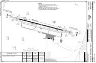
UK AIP (7 May 09) AD 2-EGPA-1-1 Civil Aviation Authority AMDT 5/09
UK AIP (7 May 09) AD 2-EGPA-1-1 Civil Aviation Authority AMDT 5/09
UK AIP (7 May 09) AD 2-EGPA-1-1 Civil Aviation Authority AMDT 5/09

You also want an ePaper? Increase the reach of your titles
YUMPU automatically turns print PDFs into web optimized ePapers that Google loves.
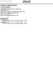
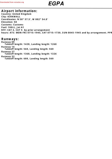
Downloaded from rutracker.org<strong>EGPA</strong>Airport information:Country: United KingdomCity: KIRKWALLCoordinates: N 58° 57.5', W 002° 54.0'Elevation: 58Customs: CustomsFuel: 100LL, Jet A1RFF: CAT 4, CAT 5 by prior arrangementhours: ATS: MON-FRI 0715-1945, SAT 0715-1730, SUN 0845-1945 and by arrangement. PPRRunways:Runway <strong>09</strong>Takeoff length: 1428, Landing length: 1268Runway 14Takeoff length: 560, Landing length: 560Runway 27Takeoff length: 1368, Landing length: 1326Runway 32Takeoff length: 680, Landing length: 560
If you like to use this charts, please, buy a subscription for nDAC.For rutracker.orgILS RWY 27 CAT A/B/CKirkwall APP/TWR ATIS118.3 108.650 - 230 NOV 11United Kingdom - <strong>EGPA</strong> / KOIKIRKWALLPANS OPSILS/DME 110.1 IKIR FAT 272° DTHR Elev 39 <strong>AD</strong> Elev 58 TL ATC TA 3000W003 20 W003 104W8832 WarningACFT to remain within11.6nm to the east of <strong>AD</strong>when D8<strong>09</strong> (North) andD8<strong>09</strong> (Central) are active.5191578253131065395510nm736D3 IKIRD3 KWL620643686Later of2000W003 00W002 50 W002 40 W002 30834DIRECT ARRIVALS IAFDCT ARRSee 10-2D8.8 IKIR2600D9 KWLD10.8 IKIR335 DME requiredD11 KWLKirkwall395 KW725825IAFD8.8 IKIRD9 KWL190346298R197KirkwallD108.6 KWL2022600263270°279IAF223NDB KWin lieu ofD8 IKIR 1D8.2 KWL064°CAT A/B:080°R0468.8D5 IKIRD5.2 KWL286may be usedVOR KWLR1041900D3 IKIRD3.2 KWL1900IKIR/D9 KWL Arc226°D8.8 IKIR/D9 KWL Arc2R080272°ILS/DME110.1 IKIRN5900D8<strong>09</strong> (North)Moray Firth55000NOTAMN585050 - 2LOC reduced coverageof + - 10° at 18nm and + - 35°at 10nm due to terrain.1 CAT A/B: D7.5 IKIR / D7.7 KWL017°388DCT ARR2600D10.8 IKIRD11 KWL180 36026 KWL 19D8<strong>09</strong> (Central)Moray Firth55000NOTAMegpa02iaip00EU OPSNavtech -MAPtD0.5 IKIR / D0.7 KWLClimb on 272° to 2000or D3 IKIR / D3 KWLwhichever later, turn leftclimbing to 2600to KWL .TCH 41ACFT ILS+DME LOC+DMEABCD240 380(200)750mNA(341)1200mNA100 120600 7202600GSROD 3.5°8048084016<strong>09</strong>60FAF-MAPt 3:23 2:42 2:15 1:56 1:41KWL064°D3 IKIRD3.2 KWLCAT A/B: 080°D5 IKIRD5.2 KWLD8 IKIR 1D8.2 KWLChange: New spec.THIS CHART IS A PART OF NAVIGRAPH CHARTS AND IS INTENDED FOR FLIGHT SIMULATION USE ONLYLOC:900a South of RWY <strong>09</strong>/27.3.5°272°1900SeeChartIKIR reads D0 at DTHR.KWL reads D0.2 at DTHR.0 1 2 3 4 5 6 7 8 9 10 11 12 13 nmCircling Circling aDME 3.5° DME 3.5° LDA 1326x46650 (592) 650 (592)IKIR ALT KWL ALT 4350x150ft1.5km 1.5kmP 3.5° (47)5 1900 5.2 1900650 (592) 650 (592)1.6km 1.6km4 1530 5 1830G1250 (1192) 750 (692)3 1160 4 14602.4km 2.4km2 780 3 1<strong>09</strong>0NA NA1 410 2 7101400.7 380 0.9 380450IALS
If you like to use this charts, please, buy a subscription for nDAC.For rutracker.orgVOR RWY <strong>09</strong> CAT A/B/CKirkwall APP/TWR ATIS118.3 108.650 - 330 NOV 11United Kingdom - <strong>EGPA</strong> / KOIKIRKWALLPANS OPSegpa03iaip00EU OPSNavtech -VOR/DME 108.6 KWL FAT 089° DTHR Elev 38 <strong>AD</strong> Elev 58 TL ATC TA 3000W003 20 W003 104WDME required519157813101 CAT A/B: 116°2 CAT A/B: D9 KWL / D8.5 IORK3 ALTN PROCEDURE: 270°SeeChart25365395522400883D6.8 KWLD6.3 IORK620R279D10 KWLD9.5 IORK089°643D3.5 KWLD3 IORK089°R258686CAT A/B:257°245°3D10 KWLD9.5 IORKD10.5 IORK/D11 KWL Arc2400KWL reads D0.5 at DTHR.IORK reads D0 at DTHR.2400W003 00 W002 50 W002 40 W002 30834D10.5 IORK/D11 KWL Arc7367252D6.8 KWLD6.3 IORK335DME8253.4°110.1 IORK190346R197DIRECT ARRIVALSSee 10-2298202223D3.5 KWLD3 IORK10002600270°2633123°1min388DCT ARRD13 KWLD12.5 IORK245°CAT A/B: 257°KirkwallD108.6 KWL1279 IAFD11 KWLD10.5 IORK2600KWLnm 12 11 10 9 8 7 6 5 4 3 2 1 0ACFT VOR+DME Circling Circling aA650 (592) 650 (592)550 (512) 1.5km 1.5kmB1500m 650 (592) 650 (592)1.6km 1.6kmC550 (512) 1250 (1192) 750 (692)1600m 2.4km 2.4kmD NA NA NAGS 80 100 120 140 160ROD 3.4° 490 610 730 850 980FAF-MAPt 4:21 3:29 2:54 2:29 2:10 a South of RWY <strong>09</strong>/27.R046D3 KWLD3 IORKDCT ARRD13 KWLIAF D12.5 IORKD11 KWLD10.5 IORKD8<strong>09</strong> (North)Moray Firth55000NOTAMD8<strong>09</strong> (Central)Moray Firth55000NOTAMLDA 1268x464160x150ftP 3.5°R (42)Change: New spec.THIS CHART IS A PART OF NAVIGRAPH CHARTS AND IS INTENDED FOR FLIGHT SIMULATION USE ONLYIAF2862600Later of150026180 360KWL10nm19226°2600GN5900N5850MAPt D1 KWL / D0.5 IORKClimb on 089° to 1500 orD3 KWL / D3 IORK whicheverlater, turn left climbing to 2600to KWL .NotePilots should take account of climbperformance to arrange their flightto reach KWL at .DME 3.4°KWL ALT6.8654321.824002110174013801010650550DME 3.4°IORK ALT6.3654321.3260024002290192015601190830550FALS50 - 3
If you like to use this charts, please, buy a subscription for nDAC.For rutracker.orgVOR RWY 27 CAT A/B/CKirkwall APP/TWR ATIS118.3 108.650 - 430 NOV 11United Kingdom - <strong>EGPA</strong> / KOIKIRKWALLPANS OPS50 - 4Navtech -VOR/DME 108.6 KWL FAT 274° DTHR Elev 39 <strong>AD</strong> Elev 58 TL ATC TA 3000W003 20 W003 10W003 00834W002 50 W002 40 W002 30883 FAT offset 2° north IAFD9 KWLDCT ARR1 CAT A/B: D7.7 KWL / D7.5 IKIR4WD8.8 IKIR2600643335736IAFD11 KWLD10.8 IKIR1DMEKirkwall D8.2 KWLD108.6 KWL110.1 IKIRD8 IKIR3253686519825N59Later ofD5.2 KWL002982000 725202190D5 IKIRD3 KWLD3 IKIR620286223346D8<strong>09</strong> (North)D3.2 KWLMoray Firth1578D3 IKIR55000NOTAMMAPt131010nm3 WarningACFT to remain within11.6nm to the east of <strong>AD</strong>when D8<strong>09</strong> (North) andD8<strong>09</strong> (Central) are active.KWL955Climb on 274° to 2000or D3 KWL / D3 IKIRwhichever later, turn leftclimbing to 2600 to KWL .KWL reads D0.2 at DTHR.IKIR reads D0 at DTHRIAFD9 KWLD8.8 IKIR2600017°R197KWL2600388DCT ARRD11 KWLD10.8 IKIR064°270°2632792600D3.2 KWLD3 IKIR2CAT A/B: 082°3.4°CAT A/B: 082°064°2DIRECT ARRIVALSSee 10-2R046R106D8.8 IKIR/D9 KWL ArcD5.2 KWLD5 IKIRD8.2 KWLD8 IKIR274°1R082D8<strong>09</strong> (Central)Moray Firth55000NOTAMSeeChartN58502 DME U/S: 2minCAT A/B: 3minChange: New spec.THIS CHART IS A PART OF NAVIGRAPH CHARTS AND IS INTENDED FOR FLIGHT SIMULATION USE ONLY900190026180 3608.8KWLI1900274°KIR/D9 KWL Arc19226°19000 1 2 3 4 5 6 7 8 9 10 11 12 13 nmACFT VOR+DME VOR VOR a Circling Circling b DME 3.4° DME 3.4° LDA 1326x46650 (592) 650 (592) IKIR ALT KWL ALT 4350x150ftA590 (551) 1.5km c 1.5km cP 3.5° (47)(411) (551)5 5.2450 5901900 19002300m 650 (592) 650 (592)B1500m 2100m1.6km c 1.6km c 4 1540 5 1830G(551) (1192) (692)C590 1250 7503 1180 4 14702500m 2.4km d 2.4km d2 820 3 1110D NA NA NA NA NA 1 450 2 750GS 80 100 120 140 160 c 2.1km after VOR1.2 450ROD 3.4° 480 600 720 840 960 2.3km after Non CDFA. a Non CDFA.FAF-MAPt 3:54 3:07 2:36 2:14 1:57 d 2.5km after Non CDFA. b South of RWY <strong>09</strong>/27. 450egpa04iaip00EU OPSIALS
If you like to use this charts, please, buy a subscription for nDAC.For rutracker.orgNDB RWY <strong>09</strong> CAT A/B/CKirkwall APP/TWR ATIS118.3 108.650 - 530 NOV 11United Kingdom - <strong>EGPA</strong> / KOIKIRKWALLNDB 395 KW FAT <strong>09</strong>2° DTHR Elev 38 <strong>AD</strong> Elev 58 TL ATC TA 3000PANS OPSW003 20 W003 104W1578DME required5192539551310653620D10.5 ID3 IORKD3.5 KWLO8832400102°081°643CAT A/B:260°248°3D9.5 IORKD10 KWLW003 00 W002 50 W002 40 W002 30834D 10.5 I736686D6.3 IORKD6.8 KWL725<strong>09</strong>2°2400RK/D11 KWL Arc1 CAT A/B: 116°2 CAT A/B: D8.5 IORK/D9 KWL3 ALTN PROCEDURE: 270°ORK/D11 KWL ArcFAT offset 129m/ 423ft northKirkwall395 KW2IAF825190346335017°2982022600DME223270°263110.1 IORK123°1minKirkwallD108.6 KWL1279 IAFD10.5 IORKD11 KWL388DCT ARR2600D12.5 IORKD13 KWL286226°Later of1500D3 IORKD3 KWL26180 360KW10nm226°DCT ARR2600D12.5 IORKIAF D13 KWLD10.5 IORKD11 KWLDIRECT ARRIVALSSee 10-219N5900D8<strong>09</strong> (North)Moray Firth55000NOTAMN5850D8<strong>09</strong> (Central)Moray Firth55000NOTAM50 - 5egpa05iaip00EU OPSNavtech -SeeChartnm240011D9.5 IORKD10 KWL 210<strong>09</strong>2°KWL reads D0.5 at DTHR.IORK reads D0 at DTHR.98D6.3 IORK D3 IORKD6.8 KWL D3.5 KWL 3 KW7653.5°1000432248°CAT A/B: 260°102600ACFT NDB+DME Circling Circling aDME 3.5°650 (592) 650 (592)KWL ALTA570 (532) 1.5km 1.5km6.8 24001500m 650 (592) 650 (592)B1.6km 1.6km6 2110C570 (532) 1250 (1192) 750 (692)5 17401700m 2.4km 2.4km4 1380D NA NA NA3 1010GS 80 100 120 140 1602 650ROD 3.5° 490 610 730 850 9801.8 570FAF-MAPt 4:21 3:29 2:54 2:29 2:10 a South of RWY <strong>09</strong>/27.D0.5 IORK / D1 KWLClimb on <strong>09</strong>2° to 1500 orD3 IORK / D3 KWL whichever later,turn left climbing to 2600 to KW .NotePilots should take accountof climb performance to arrangetheir flight to reach KW at 2600 .LDA 1268x464160x150ftP 3.5°R (42)Change: New spec.THIS CHART IS A PART OF NAVIGRAPH CHARTS AND IS INTENDED FOR FLIGHT SIMULATION USE ONLYMAPtDME 3.5°IORK ALT6.3654321.324002290192015601190830570GFALS
If you like to use this charts, please, buy a subscription for nDAC.For rutracker.orgNDB RWY 27Kirkwall APP/TWR ATIS118.3 108.650 - 6NDB/DME CAT A/B/C30 NOV 11United Kingdom - <strong>EGPA</strong> / KOIKIRKWALLPANS OPSNDB 395 KW FAT 272° DTHR Elev 39 <strong>AD</strong> Elev 58 TL ATC TA 3000W003 20 W003 10W003 00W002 50 W002 40 W002 30834DCT ARR4W883IAFFAT offset 129m/ 423ft northD8.8 IKIR2600643 DME required D9 KWLD10.8 IKIRD11 KWL2736335WarningIAFACFT to remain withinDIRECT ARRIVALS11.6nm to the east of <strong>AD</strong>See 10-2Kirkwall D8 IKIR 1when D8<strong>09</strong> (North) and395 KW D8.2 KWLD8<strong>09</strong> (Central) are active. 686 DME2253110.1 IKIRN59519Later ofD5 IKIR002982000 725 825 202D5.2 KWL190D3 IKIRD3 KWL286620223346D3 IKIRD3.2 KWLD8<strong>09</strong> (North)IAF1578Moray Firth55000KirkwallNOTAM955D108.6 KWLIAF1310D8.8 IKIR 263D9 KWLN585065327910nm2600270°CAT A/B:066°080°19008.8272°I K IR/D9 KWL Arc1900L ArcWD8.8 IKIR/D9 K226°284°260°180 36050 - 6egpa06iaip00EU OPSNavtech -1 CAT A/B: D7.5 IKIR / D7.7 KWLMAPtD0.5 IKIR / D0.7 KWLClimb on 272° to 2000or D3 IKIR /D3 KWLwhichever later, turn leftclimbing to 2600 to KW .017°2600388DCT ARR2600D10.8 IKIRD11 KWLD3 IKIRKW D3.2 KWL066°CAT A/B: 080°ACFT NDB+DME Circling Circling a650 (592) 650 (592)A1.5km 1.5km450 (411) 650 (592) 650 (592)B1500m 1.6km 1.6kmC1250 (1192) 750 (692)2.4km 2.4kmD NA NA NAGS 80 100 120 140 160ROD 3.4° 480 600 720 840 960FAF-MAPt 3:23 2:42 2:15 1:56 1:41 a South of RWY <strong>09</strong>/27.D5 IKIRD5.2 KWLD8 IKIR 1D8.2 KWL272°D8<strong>09</strong> (Central)Moray Firth55000NOTAMChange: New spec.THIS CHART IS A PART OF NAVIGRAPH CHARTS AND IS INTENDED FOR FLIGHT SIMULATION USE ONLY3.5°26900KW191900SeeChartKWL reads D0.2 at DTHR.IKIR reads D0 at DTHR.0 1 2 3 4 5 6 7 8 9 10 nmDME 3.4° DME 3.4° LDA 1326x46KWL ALT IKIR ALT 4350x150ft5.2 1900 5 1900P 3.5° (47)5 1830 4 15404 1470 3 1180G3 1100 2 8102 740 1 4501.2 450450IALS
If you like to use this charts, please, buy a subscription for nDAC.For rutracker.orgNDB RWY 27 CAT A/B/CKirkwall APP/TWR ATIS118.3 108.650 - 730 NOV 11United Kingdom - <strong>EGPA</strong> / KOIKIRKWALLNDB 395 KW FAT 272° DTHR Elev 39 <strong>AD</strong> Elev 58 TL ATC TA 3000W003 20 W003 10W003 00W002 50 W002 40 W002 30834883 FAT offset 129m/ 423ft north When D8<strong>09</strong> North is active this4Wprocedure is limited to MAX 110kt.643335736IAFPANS OPS25351915789551310653620200010nm686725Kirkwall395 KW8252982021903462600270°263279223063°CAT A/B:286080°272°1 WarningACFT to remain within11.6nm to the east of <strong>AD</strong>when D8<strong>09</strong> (North) andD8<strong>09</strong> (Central) are active.1N5900D8<strong>09</strong> (North)Moray Firth55000NOTAMN585038826180 360KW19D8<strong>09</strong> (Central)Moray Firth55000NOTAM50 - 7MAPt KWClimb on 272° to 2000turn left climbing to KWto .26002600KW2min063°CAT A/B: 080°, 3min272°1500egpa07iaip00EU OPSNavtech -ACFTABCDNDB600 (561)2200mNANDB a600(561)2400m600 (561)2600mNA0 1 2 3 4 5 6 7 8 9 10 11 12 13 nmCircling Circling b a Non CDFA.LDA 1326x46650 (592) 650 (592) b South of RWY <strong>09</strong>/27.4350x150ft2.2km c 2.2km ccP 3.5° (47)2.4km after Non CDFA.650 (592) 650 (592)cc d2.2km 2.2km 2.6km after Non CDFA.G1250 (1192) 750 (692)2.4km d 2.4km dNANAChange: New spec.THIS CHART IS A PART OF NAVIGRAPH CHARTS AND IS INTENDED FOR FLIGHT SIMULATION USE ONLY450IALSReverse side blank
If you like to use this charts, please, buy a subscription for nDAC.For rutracker.org53 - 1 30 NOV 11 United Kingdom - <strong>EGPA</strong> / KOIHELICOPTERKIRKWALLThe following Minima is for Public Transport Helicopters and conforms to JAR -OPS3 regulations.STRAIGHT-IN APPROACHR/W Procedure DA/ DH/ Full Inter Basic No ALSMDA MDH >=720 420-719 < 420QNH QFE RVR RVR RVR RVRft ft m m m m<strong>09</strong> ILS/DME 240 200 500 600 700 1000<strong>09</strong> LOC/DME 530 500 1000 1000 1000 1000<strong>09</strong> VOR/DME 550 520 1000 1000 1000 1000<strong>09</strong> NDB/DME 570 540 1000 1000 1000 100027 ILS/DME 240 200 N/A 600 700 100027 LOC/DME 380 350 N/A 1000 1000 100027 VOR/DME 450 420 N/A 1000 1000 100027 VOR 590 560 N/A 1000 1000 100027 NDB/DME 450 420 N/A 1000 1000 100027 NDB 600 570 N/A 1000 1000 1000Notes:CIRCLINGR/W Procedures MDA MDH VisQNH QFEft ft mAll procedures 650 600 800All procedures (1) 650 600 800Notes:(1) South of runway <strong>09</strong>/27.© Navtech -egpa01haorg0Reverse side blankTHIS Change: CHART New IS Spec. A PART OF NAVIGRAPH CHARTS AND IS INTENDED FOR FLIGHT SIMULATION USE ONLY