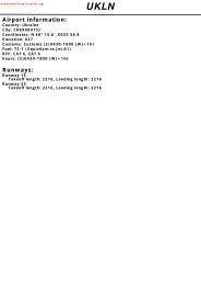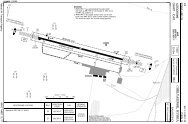
UK AIP (7 May 09) AD 2-EGPA-1-1 Civil Aviation Authority AMDT 5/09
UK AIP (7 May 09) AD 2-EGPA-1-1 Civil Aviation Authority AMDT 5/09
UK AIP (7 May 09) AD 2-EGPA-1-1 Civil Aviation Authority AMDT 5/09

You also want an ePaper? Increase the reach of your titles
YUMPU automatically turns print PDFs into web optimized ePapers that Google loves.
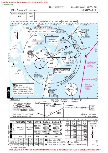
If you like to use this charts, please, buy a subscription for nDAC.For rutracker.orgVOR RWY 27 CAT A/B/CKirkwall APP/TWR ATIS118.3 108.650 - 430 NOV 11United Kingdom - <strong>EGPA</strong> / KOIKIRKWALLPANS OPS50 - 4Navtech -VOR/DME 108.6 KWL FAT 274° DTHR Elev 39 <strong>AD</strong> Elev 58 TL ATC TA 3000W003 20 W003 10W003 00834W002 50 W002 40 W002 30883 FAT offset 2° north IAFD9 KWLDCT ARR1 CAT A/B: D7.7 KWL / D7.5 IKIR4WD8.8 IKIR2600643335736IAFD11 KWLD10.8 IKIR1DMEKirkwall D8.2 KWLD108.6 KWL110.1 IKIRD8 IKIR3253686519825N59Later ofD5.2 KWL002982000 725202190D5 IKIRD3 KWLD3 IKIR620286223346D8<strong>09</strong> (North)D3.2 KWLMoray Firth1578D3 IKIR55000NOTAMMAPt131010nm3 WarningACFT to remain within11.6nm to the east of <strong>AD</strong>when D8<strong>09</strong> (North) andD8<strong>09</strong> (Central) are active.KWL955Climb on 274° to 2000or D3 KWL / D3 IKIRwhichever later, turn leftclimbing to 2600 to KWL .KWL reads D0.2 at DTHR.IKIR reads D0 at DTHRIAFD9 KWLD8.8 IKIR2600017°R197KWL2600388DCT ARRD11 KWLD10.8 IKIR064°270°2632792600D3.2 KWLD3 IKIR2CAT A/B: 082°3.4°CAT A/B: 082°064°2DIRECT ARRIVALSSee 10-2R046R106D8.8 IKIR/D9 KWL ArcD5.2 KWLD5 IKIRD8.2 KWLD8 IKIR274°1R082D8<strong>09</strong> (Central)Moray Firth55000NOTAMSeeChartN58502 DME U/S: 2minCAT A/B: 3minChange: New spec.THIS CHART IS A PART OF NAVIGRAPH CHARTS AND IS INTENDED FOR FLIGHT SIMULATION USE ONLY900190026180 3608.8KWLI1900274°KIR/D9 KWL Arc19226°19000 1 2 3 4 5 6 7 8 9 10 11 12 13 nmACFT VOR+DME VOR VOR a Circling Circling b DME 3.4° DME 3.4° LDA 1326x46650 (592) 650 (592) IKIR ALT KWL ALT 4350x150ftA590 (551) 1.5km c 1.5km cP 3.5° (47)(411) (551)5 5.2450 5901900 19002300m 650 (592) 650 (592)B1500m 2100m1.6km c 1.6km c 4 1540 5 1830G(551) (1192) (692)C590 1250 7503 1180 4 14702500m 2.4km d 2.4km d2 820 3 1110D NA NA NA NA NA 1 450 2 750GS 80 100 120 140 160 c 2.1km after VOR1.2 450ROD 3.4° 480 600 720 840 960 2.3km after Non CDFA. a Non CDFA.FAF-MAPt 3:54 3:07 2:36 2:14 1:57 d 2.5km after Non CDFA. b South of RWY <strong>09</strong>/27. 450egpa04iaip00EU OPSIALS