UK AIP (7 May 09) AD 2-EGPA-1-1 Civil Aviation Authority AMDT 5/09
UK AIP (7 May 09) AD 2-EGPA-1-1 Civil Aviation Authority AMDT 5/09
UK AIP (7 May 09) AD 2-EGPA-1-1 Civil Aviation Authority AMDT 5/09

You also want an ePaper? Increase the reach of your titles
YUMPU automatically turns print PDFs into web optimized ePapers that Google loves.
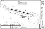
If you like to use this charts, please, buy a subscription for nDAC.For rutracker.orgNDB RWY <strong>09</strong> CAT A/B/CKirkwall APP/TWR ATIS118.3 108.650 - 530 NOV 11United Kingdom - <strong>EGPA</strong> / KOIKIRKWALLNDB 395 KW FAT <strong>09</strong>2° DTHR Elev 38 <strong>AD</strong> Elev 58 TL ATC TA 3000PANS OPSW003 20 W003 104W1578DME required5192539551310653620D10.5 ID3 IORKD3.5 KWLO8832400102°081°643CAT A/B:260°248°3D9.5 IORKD10 KWLW003 00 W002 50 W002 40 W002 30834D 10.5 I736686D6.3 IORKD6.8 KWL725<strong>09</strong>2°2400RK/D11 KWL Arc1 CAT A/B: 116°2 CAT A/B: D8.5 IORK/D9 KWL3 ALTN PROCEDURE: 270°ORK/D11 KWL ArcFAT offset 129m/ 423ft northKirkwall395 KW2IAF825190346335017°2982022600DME223270°263110.1 IORK123°1minKirkwallD108.6 KWL1279 IAFD10.5 IORKD11 KWL388DCT ARR2600D12.5 IORKD13 KWL286226°Later of1500D3 IORKD3 KWL26180 360KW10nm226°DCT ARR2600D12.5 IORKIAF D13 KWLD10.5 IORKD11 KWLDIRECT ARRIVALSSee 10-219N5900D8<strong>09</strong> (North)Moray Firth55000NOTAMN5850D8<strong>09</strong> (Central)Moray Firth55000NOTAM50 - 5egpa05iaip00EU OPSNavtech -SeeChartnm240011D9.5 IORKD10 KWL 210<strong>09</strong>2°KWL reads D0.5 at DTHR.IORK reads D0 at DTHR.98D6.3 IORK D3 IORKD6.8 KWL D3.5 KWL 3 KW7653.5°1000432248°CAT A/B: 260°102600ACFT NDB+DME Circling Circling aDME 3.5°650 (592) 650 (592)KWL ALTA570 (532) 1.5km 1.5km6.8 24001500m 650 (592) 650 (592)B1.6km 1.6km6 2110C570 (532) 1250 (1192) 750 (692)5 17401700m 2.4km 2.4km4 1380D NA NA NA3 1010GS 80 100 120 140 1602 650ROD 3.5° 490 610 730 850 9801.8 570FAF-MAPt 4:21 3:29 2:54 2:29 2:10 a South of RWY <strong>09</strong>/27.D0.5 IORK / D1 KWLClimb on <strong>09</strong>2° to 1500 orD3 IORK / D3 KWL whichever later,turn left climbing to 2600 to KW .NotePilots should take accountof climb performance to arrangetheir flight to reach KW at 2600 .LDA 1268x464160x150ftP 3.5°R (42)Change: New spec.THIS CHART IS A PART OF NAVIGRAPH CHARTS AND IS INTENDED FOR FLIGHT SIMULATION USE ONLYMAPtDME 3.5°IORK ALT6.3654321.324002290192015601190830570GFALS