UK AIP (7 May 09) AD 2-EGPA-1-1 Civil Aviation Authority AMDT 5/09
UK AIP (7 May 09) AD 2-EGPA-1-1 Civil Aviation Authority AMDT 5/09
UK AIP (7 May 09) AD 2-EGPA-1-1 Civil Aviation Authority AMDT 5/09

Create successful ePaper yourself
Turn your PDF publications into a flip-book with our unique Google optimized e-Paper software.
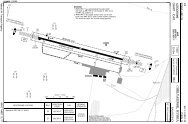
If you like to use this charts, please, buy a subscription for nDAC.For rutracker.orgNDB RWY 27 CAT A/B/CKirkwall APP/TWR ATIS118.3 108.650 - 730 NOV 11United Kingdom - <strong>EGPA</strong> / KOIKIRKWALLNDB 395 KW FAT 272° DTHR Elev 39 <strong>AD</strong> Elev 58 TL ATC TA 3000W003 20 W003 10W003 00W002 50 W002 40 W002 30834883 FAT offset 129m/ 423ft north When D8<strong>09</strong> North is active this4Wprocedure is limited to MAX 110kt.643335736IAFPANS OPS25351915789551310653620200010nm686725Kirkwall395 KW8252982021903462600270°263279223063°CAT A/B:286080°272°1 WarningACFT to remain within11.6nm to the east of <strong>AD</strong>when D8<strong>09</strong> (North) andD8<strong>09</strong> (Central) are active.1N5900D8<strong>09</strong> (North)Moray Firth55000NOTAMN585038826180 360KW19D8<strong>09</strong> (Central)Moray Firth55000NOTAM50 - 7MAPt KWClimb on 272° to 2000turn left climbing to KWto .26002600KW2min063°CAT A/B: 080°, 3min272°1500egpa07iaip00EU OPSNavtech -ACFTABCDNDB600 (561)2200mNANDB a600(561)2400m600 (561)2600mNA0 1 2 3 4 5 6 7 8 9 10 11 12 13 nmCircling Circling b a Non CDFA.LDA 1326x46650 (592) 650 (592) b South of RWY <strong>09</strong>/27.4350x150ft2.2km c 2.2km ccP 3.5° (47)2.4km after Non CDFA.650 (592) 650 (592)cc d2.2km 2.2km 2.6km after Non CDFA.G1250 (1192) 750 (692)2.4km d 2.4km dNANAChange: New spec.THIS CHART IS A PART OF NAVIGRAPH CHARTS AND IS INTENDED FOR FLIGHT SIMULATION USE ONLY450IALSReverse side blank