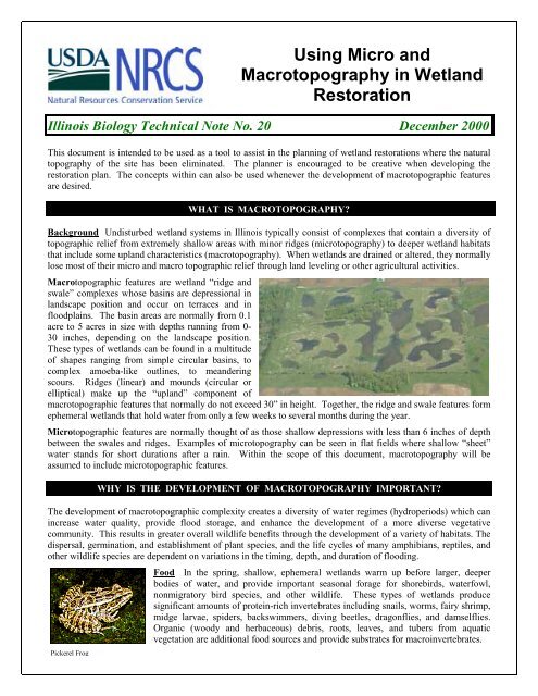
Using Micro and Macrotopography in Wetland Restoration
Using Micro and Macrotopography in Wetland Restoration
Using Micro and Macrotopography in Wetland Restoration

Create successful ePaper yourself
Turn your PDF publications into a flip-book with our unique Google optimized e-Paper software.
Succession <strong>and</strong> Long-term Management Succession of wetl<strong>and</strong>s is a natural process that can result <strong>in</strong>significant habitat changes over time. Primary changes <strong>in</strong>clude, for example, the development of aquaticmacrophytes, <strong>in</strong>vasion of wetl<strong>and</strong>s by trees <strong>and</strong> shrubs, <strong>and</strong> canopy closure over wetl<strong>and</strong>s embedded <strong>in</strong> forestedl<strong>and</strong>scapes. Such changes can alter the species composition of wetl<strong>and</strong>s over time by select<strong>in</strong>g for species thatfavor or can tolerate later successional stages. Early successional species will consequently be lost, therebylower<strong>in</strong>g diversity, <strong>and</strong> can only be restored by periodically revers<strong>in</strong>g succession. Plans to periodically (e.g.every 10-20 years) reverse the effects of succession <strong>in</strong> some portion of all wetl<strong>and</strong>s (e.g. 5-10% of the totalnumber per year) are important to consider. Natural processes that can reverse succession vary among regions<strong>and</strong> should mimic local regimes but may <strong>in</strong>clude flood<strong>in</strong>g, dry<strong>in</strong>g, <strong>and</strong> burn<strong>in</strong>g. Human disturbance regimes suchas mow<strong>in</strong>g, timber harvest, draw-downs, or even herbicides may be considered, but only with extreme cautionbecause of possible negative <strong>in</strong>direct effects.MACROTOPOGRAHIC BASINSThe macrotopograhic bas<strong>in</strong>s are described <strong>in</strong> abbreviated format as: shape/size/depth.Where:1) the shape is described below2) the size is <strong>in</strong> acres3) the depth is <strong>in</strong> feetFor example, a macrotopograhic bas<strong>in</strong> described as Oxbow/1.5/0.5-1.0-2.0:1) has shape #2 below,2) is 1.5 acres <strong>in</strong> size, <strong>and</strong>3) is composed of 3 depths (0.5’, 1.0’ <strong>and</strong> 2.0’)BASIN SHAPE DESCRIPTIONSBas<strong>in</strong>s should be irregular <strong>in</strong> shape. Irregular shapes <strong>in</strong>crease edge <strong>and</strong> provide additional cover for waterfowl<strong>and</strong> other wildlife utiliz<strong>in</strong>g the site.1) Shape: OvalDescription: Generally circular2) Shape: OxbowDescription: Kidney shaped with 2 lobes3) Shape: AmoebaDescription: Multiple lobes with r<strong>and</strong>om shape,high perimeter to surface area ratio4) Shape: Me<strong>and</strong>erDescription: Mimics an ab<strong>and</strong>oned stream channelme<strong>and</strong>er4
DEPTH DESCRIPTIONSAERIAL VIEWCROSS SECTIONWhen 1 depth is <strong>in</strong>dicated:• the bas<strong>in</strong> is primarily 1 depthWhen 2 depths are <strong>in</strong>dicated:• each depth composes approximately50% of the areaWhen 3 depths are <strong>in</strong>dicated:the depths compose approximately:• deepest depth = 20% of the area• middle depth = 30% of the area• shallowest depth = 50% of the areaHABITAT MOUNDSFill excavated from the macro-topograhic bas<strong>in</strong>s can be used to create multiple upl<strong>and</strong> habitat conditions based onthe height, shape, <strong>and</strong> location of habitat mounds. Variations <strong>in</strong> habitat mound design can provide escape areas,denn<strong>in</strong>g sites, nest<strong>in</strong>g opportunities, <strong>and</strong> plant diversity, as well as provid<strong>in</strong>g visual breaks with<strong>in</strong> the wetl<strong>and</strong>complex. All side slopes for mounds should have a m<strong>in</strong>imum slope of 6:1, but should be as flat as is feasible.Note: In situations where geese are a nuisance, at least 30 feet should exist between the habitat mound <strong>and</strong> anywater surface. This area should then be planted with a vegetative barrier such as warm season grasses, trees orshrubs.Where restoration sites have a designed water level, habitat mounds should vary <strong>in</strong> elevation from above tobelow the expected normal waterl<strong>in</strong>e. Approxmately 1/3 of the mounds should be 6 <strong>in</strong>ches to 1.0 foot below thenormal water elevation, 1/3 should be 6 <strong>in</strong>ches to 1.0 foot above, <strong>and</strong> 1/3 should be at the normal water elevation.Where restoration sites do not have a designed water level, habitat mounds primarily provide upl<strong>and</strong> habitat<strong>and</strong> tend to direct water flow dur<strong>in</strong>g flood conditions. Approximately 50% of the mounds should be 6 <strong>in</strong>ches to1.0 foot above average ground level, <strong>and</strong> 50% should be 1.0 to 2.0 foot above the normal ground elevation.Mounds should mimic the natural l<strong>and</strong>scape as much as possible. For example, if the site is located on the<strong>in</strong>terior of a river oxbow, ridge <strong>and</strong> swale design may be appropriate (see figures 2 <strong>and</strong> 3). When possible, placemounds <strong>in</strong> such a way as to <strong>in</strong>crease me<strong>and</strong>er distance by direct<strong>in</strong>g water flow <strong>in</strong> a path that me<strong>and</strong>ers across theunit.MOUNDSFigure 1 Figure 2 Figure 35
ADDITIONAL MODIFICATIONSDitches of vary<strong>in</strong>g depths <strong>and</strong> widths can connect bas<strong>in</strong>sto diversify a site. They provide additional cover forwaterfowl as well as escape routes away from predators.Connection ditches may have 3:1 (or flatter) side slopes.In some cases, they can also be used for boat access tothe site for hunt<strong>in</strong>g <strong>and</strong> recreational view<strong>in</strong>g, or to limitvehicular traffic of the site. See Figure 4.Note: In situations where amphibians are the primaryspecies of concern, connect<strong>in</strong>g ditches should be limitedbecause they provide access routes for predatory fish,particularly if connected to deeper, more permanentpools.L<strong>and</strong> SlopeConnect<strong>in</strong>g ditchesFigure 4Figure 5On gently slop<strong>in</strong>g sites, an efficient means of provid<strong>in</strong>g shallow,“sheet” water habitat is through the creation of l<strong>in</strong>ear habitatmounds. The excavated material from a macrotopographic bas<strong>in</strong>is used to form a low, me<strong>and</strong>er<strong>in</strong>g ridge on the down slope sideof the bas<strong>in</strong>(s). Typical heights for the mound range from 1 to 2feet. By us<strong>in</strong>g the spoil <strong>in</strong> a creative manner, the total shallowwater on a project site can be substancially <strong>in</strong>creased. Theimpounded sheet water provides seasonal or ephemeral water forshallow feeders such as shorebirds, while the excavated bas<strong>in</strong>sprovide longer hydroperiod wetl<strong>and</strong> habitats. This method canalso be utilized where wetl<strong>and</strong> meadow conditions are desired.CONSTRUCTIONCreative Borrow<strong>in</strong>g Borrow areas for dikes or embankments can be <strong>in</strong>corporated <strong>in</strong>to the development ofmacrotopographic features. Potholes, swales, me<strong>and</strong>ers, <strong>and</strong> other shallow water habitats can serve as borrowareas for needed fill. All side slopes for bas<strong>in</strong>s should have a m<strong>in</strong>imum slope of 6:1. Note that, when feasible,slopes should be as flat as possible. Slopes exceed<strong>in</strong>g 20:1 are not considered excessive for habitat purposes.Examples of this <strong>in</strong>clude situations where equipment operators r<strong>and</strong>omly fill their scrapers leav<strong>in</strong>g shallow,s<strong>in</strong>gle-trip borrow sites. Note that the borrow areas will result <strong>in</strong> the bas<strong>in</strong>s be<strong>in</strong>g the deepest portions of thewetl<strong>and</strong> complex. In seasonal or ephemeral wetl<strong>and</strong>s these areas provide a diversity of hydroperiods by hold<strong>in</strong>gwater later <strong>in</strong>to the year than the rema<strong>in</strong>der of the wetl<strong>and</strong>.Rough-f<strong>in</strong>ish Grad<strong>in</strong>g The desired macrotopographicfeatures will have rough surfaces on all side slopes <strong>and</strong> top,an undulat<strong>in</strong>g bottom, <strong>and</strong> a ragged shorel<strong>in</strong>e.Woody Debris• Provides sunn<strong>in</strong>g <strong>and</strong> rest<strong>in</strong>g areas for herptiles• Provides loaf<strong>in</strong>g sites for waterfowl• Is a source for organic soil material• Provides additional vertical <strong>and</strong> horizontal habitat• Is an excellent substrate for <strong>in</strong>vertebratesDepend<strong>in</strong>g on water velocities the debris may or may nothave to be partially buried. Use as needed.6
ASSOCIATED TECHNICAL STANDARDSThis technical note can be used <strong>in</strong> association with the follow<strong>in</strong>g technical st<strong>and</strong>ards:• 657 Wetl<strong>and</strong> <strong>Restoration</strong>• 658 Wetl<strong>and</strong> creation• 659 Wetl<strong>and</strong> Enhancement• 644 Wetl<strong>and</strong> Wildlife Habitat Management• 646 Shallow Water Management For WildlifeREFERENCESKIEFER, J. L. U.S.D.I. Fish <strong>and</strong> Wildlife Service. 2000. Personal Communications, Ecological Services Field Office,Bloom<strong>in</strong>gton Indiana.KING, S. L. <strong>and</strong> LICHTENBERG, J. S. Habitat <strong>Restoration</strong> <strong>and</strong> Amphibians. USGS National Wetl<strong>and</strong>s Research Center.KINGSBURY, B. A. 2000. Personal Communications, Indiana University Purdue University-Fort Wayne.KNUTSON, M. G., SAUER, J. R., OLSEN, D. A., MOSSMAN, M. J., HEMESATH, L. M., AND LANNOO, M. J. 1999.Effects of L<strong>and</strong>scape Composition <strong>and</strong> Wetl<strong>and</strong> Fragmentation on Frog <strong>and</strong> Toad Abundance <strong>and</strong> Species Richness <strong>in</strong> Iowa<strong>and</strong> Wiscons<strong>in</strong>. Conservation Biology 13 (6), 1437-1446.KNUTSON, M. G., SAUER, J. R., OLSEN, D. A., MOSSMAN, M. J., HEMESATH, L. M., AND LANNOO, M. J. 2000.L<strong>and</strong>scape Associations of Frogs <strong>and</strong> Toad Species <strong>in</strong> Iowa <strong>and</strong> Wiscons<strong>in</strong>, USA. Journal of the Iowa Academy of Science107: <strong>in</strong> press.KOLOZSVARY, M. B., AND SWIHART, R. K. 1999. Habitat Fragmentation And The Distribution Of Amphibians: PatchAnd L<strong>and</strong>scape Correlates In Farml<strong>and</strong>. Can. J. Zool.:1288-1299.LAWRENCE REGIONAL RIPARIAN TECHNICAL TEAM. 1997. Draft Interim HGM Model For KansasWooded River<strong>in</strong>e Wetl<strong>and</strong>s. Lawrence, Kansas.SEMLITSCH, R. D., AND J. R. BODIE. 1998. Are Small, Isolated Wetl<strong>and</strong>s Expendable? Conservation Biology 12:1129-1133.SEMLITSCH, R. D. 1998. Biological Del<strong>in</strong>eation of Terrestrial Buffer Zones for Pond-Breed<strong>in</strong>g Salam<strong>and</strong>ers.Conservation Biology 12:1113-1119.SEMLITSCH, R. D. 2000. Pr<strong>in</strong>ciples For Management of Aquatic-Breed<strong>in</strong>g Amphibians. Journal of Wildlife Management64(3):615-631.U.S.D.A. Natural Resources Conservation Service. 2000. Techniques for Restor<strong>in</strong>g Wetl<strong>and</strong> Topography (Video), NRCSWetl<strong>and</strong>s Science Institute, NRCS Watersheds <strong>and</strong> Wetl<strong>and</strong>s Division.FOR ADDITIONAL INFORMATIONDAVE STRATMAN, BiologistUSDA Natural Resources Conservation Service6013 Lakeside Blvd. 1920 Fox DriveIndianapolis, IN 46278 Champaign, IL 61820GENE BARICKMAN, BiologistUSDA Natural Resources Conservation ServicePhone: (317) 290-3200 ext. 354 Phone: (217) 353-6636Email: dave.stratman@<strong>in</strong>.usda.govEmail: Gene.Barickman@il.usda.govThe United States Department of Agriculture (USDA) prohibits discrim<strong>in</strong>ation <strong>in</strong> all its programs <strong>and</strong> activities on the basis of race, color, nationalorig<strong>in</strong>, sex, religion, age, disability, political beliefs, sexual orientation, <strong>and</strong> marital or family status. (Not all prohibited bases apply to all programs.)Persons with disabilities who require alternative means for communication of program <strong>in</strong>formation (Braille, large pr<strong>in</strong>t, audiotape, etc.) shouldcontact USDA’s TARGET Center at (202) 720-2600 (voice <strong>and</strong> TDD).To file a compla<strong>in</strong>t of discrim<strong>in</strong>ation, write USDA, Director, Office of Civil Rights, Room 326W Whitten Build<strong>in</strong>g, 1400 Independence Avenue, SW,Wash<strong>in</strong>gton, DC 20250-9410 or call (202)720-5964 (voice <strong>and</strong> TDD). USDA is an equal opportunity provider <strong>and</strong> employer.7