WARMINSTER TOWNSHIP COMPREHENSIVE PLAN - E-Library
WARMINSTER TOWNSHIP COMPREHENSIVE PLAN - E-Library
WARMINSTER TOWNSHIP COMPREHENSIVE PLAN - E-Library

You also want an ePaper? Increase the reach of your titles
YUMPU automatically turns print PDFs into web optimized ePapers that Google loves.
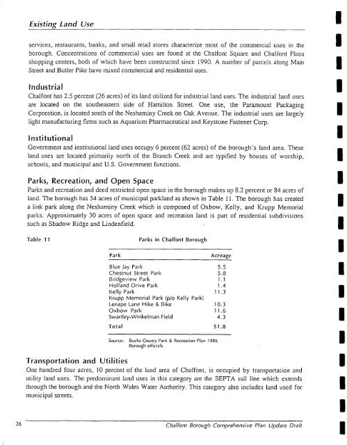
Existing Land Useservices, restaurants, banks, and small retail stores characterize most of the commercial uses in theborough. Concentrations of commercial uses are found at the Chalfont Square and Chalfont Plazashopping centers, both of which have been constructed since 1990. A number of parcels along MainStreet and Butler Pike have mixed commercial and residential uses.IndustrialChalfont has 2.5 percent (26 acres) of its land utilized for industrial land uses. The industrial land usesare located on the southeastern side of Hamilton Street. One use, the Paramount PackagingCorporation, is located south of the Neshaminy Creek on Oak Avenue. The industrial uses are largelylight manufacturing firms such as Aquarium Pharmaceutical and Keystone Fastener Corp.InstitutionalGovernment and institutional land uses occupy 6 percent (62 acres) of the borough’s land area. Theseland uses are located primarily north of the Branch Creek and are typified by houses of worship,schools, and municipal and U.S. Government functions.Parks, Recreation, and Open SpaceParks and recreation and deed restricted open space in the borough makes up S.2 percent or 84 acres ofland. The borough has 54 acres of municipal parkland as shown in Table 1 1. The borough has createda link park along the Neshaminy Creek which is composed of Oxbow, Kelly, and Krupp Memorialparks. Approximately 30 acres of open space and recreation land is part of residential subdivisionssuch as Shadow Ridge and Lindenfield.Table 11ParkParks in Chalfont BoroughAcrearcBlue jay Park 5.5Chestnut Street Park 5.8Bridgeview Park 1.1Holland Drive Park 1.4Kelly Park 11.3Krupp Memorial Park (plo Kelly Park)Lenape Lane Hike & Bike 10.3Oxbow Park 11.6Swartley-Winkelman Field 4.3Total 51 .aSource:Ducks Counry Park & Rccrcation Plan 198GBorough officialsTransportation and Uti I it iesOne hundred four acres, 10 percent of the land area of Chalfont, is occupied by transportation andutility land uses. The predominant land uses in this category are the SEPTA rail line which extendsthrough the borough and the North Wales Water Authority. This category also includes land used formunicipal streets.26 CIialfont Borough Comprehensive Plan Update DraftIBIII1I1IIIIBIIIIII