WARMINSTER TOWNSHIP COMPREHENSIVE PLAN - E-Library
WARMINSTER TOWNSHIP COMPREHENSIVE PLAN - E-Library
WARMINSTER TOWNSHIP COMPREHENSIVE PLAN - E-Library
Create successful ePaper yourself
Turn your PDF publications into a flip-book with our unique Google optimized e-Paper software.
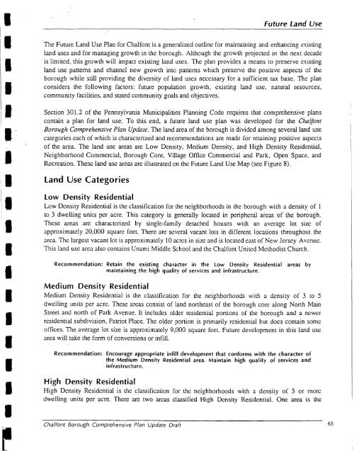
future Land UseIII.BIThe Future Land Use Plan for Chalfont is a generalized outline for maintaining and enhancing existingland uses and for managing growth in the borough. Although the growth projected in the next decadeis limited, this growth will impact existing land uses. The plan provides a means to preserve existingland use patterns and channel new growth into patterns which preserve the positive aspects of theborough while still providing the diversity of land uses necessary for a sufficient tax base. The planconsiders the following factors: future population growth, existing land use, natural resources,community facilities, and stated community goals and objectives.Section 301.2 of the Pennsylvania Municipalities Planning Code requires that comprehensive planscontain a plan for land use. To this end, a future land use plan was developed for the ChalfontBorough Comprehensive Plan Update. The land area of the borough is divided among several land usecategories each of which is characterized and recommendations are made for retaining positive aspectsof the area. The land use areas are Low Density, Medium Density, and High Density Residential,Neighborhood Commercial, Borough Core, Village Office Commercial and Park, Open Space, andRecreation. These land use areas are illustrated on the Future Land Use Map (see Figure 8).Land Use CategoriesLow Density ResidentialLow Density Residential is the classification for the neighborhoods in the borough with a density of 1to 3 dwelling units per acre. This category is generally located in peripheral areas of the borough.These areas are characterized by single-family detached houses with an average lot size ofapproximately 20,000 square feet. Thcre are several vacant lots in differcnt locations throughout thearea. The largest vacant lot is approximately 10 acres in size and is located cast of New Jcrscy Avenue.This land use area also contains Unami Middle School and the Chall'ont Unitcd Methodist Church.Recommendation: Retain the existing character in the Low Density Residentialmaintaining the high quality of services and infrastructure.areas byMedium Density ResidentialMedium Density Residential is the classification for the neighborhoods with a density of 3 to 5dwelling units per acre. These areas consist of land northeast of the borough core along North MainStreet and north of Park Avenue. It includes older residential portions of the borough and a newerresidential subdivision, Patriot Place. The older portion is primarily residential but does contain someoffices. The average lot size is approximately 9,000 square feet. Future development in this land usearea will take the form of conversions or infill.Recommendation: Encourage appropriate infill development that conforms with the character ofthe Medium Density Residential area. Maintain high quality of services andinfrastructure.High Density ResidentialHigh Density Residcntial is the classification for the neighborhoods with a density ol' 5 or moredwelling units per acre. Theic are two arcas classified High Density Residential. Onc area is thcChaliont Borough Comprehensive Plan Update Draft 65


