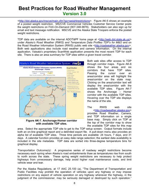
Best Practices for <strong>Road</strong> <strong>Weather</strong> <strong>Management</strong>Version 3.0. Figure AK-5 shows an exampleof a posted weight restriction. MS/CVE Commercial Vehicles Customer Service Center poststhe weight restrictions on FAX-On-Demand (907-348-9876). Stakeholders can also sign up foremail and text message notification. MSCVE and the Alaska State Troopers enforce the postedweight restrictions.TDP data are available on the internal ADOT&PF home page at under Alaska’s <strong>Road</strong> <strong>Weather</strong> (RWIS) and Temperature Data Profiles TDP’s for M&O and onthe <strong>Road</strong> <strong>Weather</strong> Information System (RWIS) public web site .Both web applications also include road weather and camera information. On the internalapplication, Vaisala’s proprietary ScanWeb application presents the most recent TDP for eachsite. There is also an area summary for TDP sites within a given travel corridor.Figure AK-7. Anchorage-Homer corridorwith available TDP sites.8Both web sites offer access to TDPthrough corridor maps. Figure AK-6shows the four areas and sixcorridors that have TDP sites.Passing the cursor over anarea/corridor area will highlight thearea/corridor on the state map.Clicking on the area/corridor text willdisplay the area/corridor with theavailable TDP sites. Figure AK-7shows the Anchorage – Homercorridor with the available TDP sites.Hovering over the TDP site displaysthe name of the site.The RWIS web siteprovides <strong>Road</strong> <strong>Weather</strong>, Camera,and TDP information on a singlebase map. Simply click on TDP atthe top of the corridor map to showthe available TDP sites for this maparea. Select the appropriate TDP site to get to the TDP setup screen. Output formats includeboth an on-line graphical report and a delimited export file. A pull-down menu also provides analpha list of available TDP sites. Three time periods are available: 24 hours, 7 days, and 31days. A calendar function provides an easy date range selection; the earliest data availability isincluded in the site metadata. TDP data are sorted into three-degree temperature bins forgraphical display.Transportation Outcome(s): A progressive series of roadway weight restrictions becomenecessary each spring when Alaska’s road embankments thaw as temperatures rise from southto north across the state. These spring weight restrictions are necessary to help protecthighways from unnecessary damage, help avoid higher road maintenance costs, and limitvehicle wear and tear.Per the Alaska Regulations, at 17 AAC 25.100 (a), “The Department of Transportation andPublic Facilities may prohibit the operation of vehicles upon any highway or may imposerestrictions on any aspect of vehicle operation on any highway whenever the highway, in thejudgment of the commissioner, may be seriously damaged or destroyed by such operation.”
Best Practices for <strong>Road</strong> <strong>Weather</strong> <strong>Management</strong>Version 3.0Limitations are therefore imposed from March through June, area by area, and road by road, byrestricting the Maximum Allowable Axle or Axle Group Weights to less than typical summer orwinter loads. Where a value of “100%” represents the normal legal maximum allowable weight,key paved and unpaved roads are temporarily constrained by public legal notice to restrictionsof 85%, 75%, or even 50% of the statutorily defined weights.Once the thaw process starts at the pavement surface and progresses downward slowly, over aperiod of days and weeks, moisture content rises and a water-saturated layer of soil generallydevelops between the uppermost (thawed) zone of pavement and structural fill, and the stillfrozenmass of sub grade beneath the thawed layer.• Trucks and trailers moving heavy cargoes press down atop this constrained system,dramatically increasing the thaw zone’s pore pressure. This potentially can cause“quick” foundation conditions, a loss of strength within the granular soil matrix, and cantrigger pavement flexure and rutting (soil displacement), constituting significant roaddamage. The real-time TDP temperature data at various depths, times of day, anddates provides a clear indication of when certain roads across the state are likely to beincapable of supporting heavy wheel loads because of the progressing thaw depth. Thisis when load limits, restricting vehicle loads to viable non-damaging levels, are posted.Reasonable thaw progression estimates are possible by observing site-specific conditionsreported by experienced maintenance station foremen. Considerations such as a road’sdrainage and soil characteristic, variable pavement age and structural condition, remainingsnow cover, and weather forecasts are all important at each TDP location. The maintenanceengineer uses the previous years’ archived TDP thaw data and the relative loss of strength fromshallow thaw depths to impose load limits. With the return of load-carrying ability within thegranular embankment structure in place below the paved (or unpaved) road surface as the thawgets deeper, load limits are then carefully lifted. Depending on the quality of the roadway’sstructural regime and moisture content circumstances, load restrictions are usually completelylifted as the thaw depth exceeds 48 inches.DOT&PF’s TDP sensors play an important role in selecting which roads to include in roadrestriction notices and to what level of restriction to apply at various dates. Alaska’s costeffectiveTDP system plays a useful and desirable role in providing real-time temperature datafor year-round uses, but its spring applications are particularly critical and unparalleled inprotecting the state’s $10 billion highway infrastructure, while realistically balancing thecompeting needs of surface transportation, commerce and industrial livelihoods. TDP data arealso used for road design and arctic research.Implementation Issues: The TDP program incorporates two statewide networks, one for TDPsco-located with RWIS sites and one that is comprised of stand-alone installations. The colocatedsites are polled hourly by the RWIS servers in Anchorage and Juneau and packagedinto a 24 hour TDP data file. The stand-alone sites are polled periodically by the Central RegionHighway Data Section (CR/HDS). TDP data are transferred to Juneau where they are loaded toan Oracle relational database at 5:00am, noon, and 5:00pm each day.Campbell Scientific data loggers (model CR-10X) installed in adjacent roadside cabinets collectthe CR/HDS TDP data. The CR/HDS polls the TDP sites via modem periodically, more often inthe spring, forwards hourly data files to Juneau for loading into an Oracle relational database.Manual readings can be taken from the remaining older MRC thermistor probes on-site whenconnected to a hand-held display. Most of the stand-alone TDP sites also have othertemperature sensors installed such as ambient air temperature and the reference temperature9