AccuGrade® Compaction - Kelly Tractor
AccuGrade® Compaction - Kelly Tractor
AccuGrade® Compaction - Kelly Tractor

You also want an ePaper? Increase the reach of your titles
YUMPU automatically turns print PDFs into web optimized ePapers that Google loves.
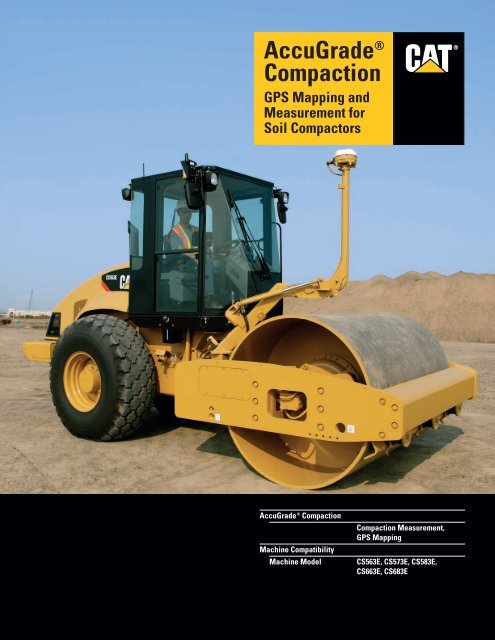
AccuGrade ®<strong>Compaction</strong>GPS Mapping andMeasurement forSoil Compactors®AccuGrade ® <strong>Compaction</strong>Machine CompatibilityMachine Model<strong>Compaction</strong> Measurement,GPS MappingCS563E, CS573E, CS583E,CS663E, CS683E
AccuGrade ® <strong>Compaction</strong> GPS Mapping and Measurement for Soil CompactorsThe AccuGrade ® system simplifies compaction, increases productivity, lowers operatingcosts and documents compaction results.<strong>Compaction</strong> Measurement System✔ The <strong>Compaction</strong> Measurement systemmeasures drum movement to determinesoil stiffness. This new <strong>Compaction</strong>Measurement system providesoperators, contractors and projectowners with a variety of benefitsthat increase production and simplifyjob-site documentation. pg. 4AccuGrade ® Attachment ReadyOption (ARO)✔ The AccuGrade ARO machine simplifiessystem installation. The AccuGradesystem is designed and integrated intothe machine systems and controls tooptimize performance and reliability.pg. 5AccuGrade ® GPS✔ The GPS System uses Global PositioningSystem satellites to determine precisemachine position. pg. 6100% compaction quality control andquality assurance using AccuGrade<strong>Compaction</strong>. System flexibility allows theAccuGrade electronic components to beeasily interchanged to meet a wide rangeof application and site-specific compactionrequirements.2
AccuGrade Office Software✔ AccuGrade Office software managesand converts engineering and surveydata for use in the machine. It alsoimports and stores compaction datafrom the machine for analysis of thecompaction values. pg. 8Features and Benefits✔ AccuGrade <strong>Compaction</strong> delivers a widerange of customer benefits that increaseoperator efficiency and productivity,improve accuracy, reduce materialcosts, reduce surveying and labor costs,and lower overall operating costs.pg. 9✔ New Feature3
<strong>Compaction</strong> Measurement SystemThe <strong>Compaction</strong> Measurement system measures compaction to optimize machineproductivity and improve job quality.By alerting the operator to the presenceof these anomalies, the contractor hasthe opportunity to investigate and,if necessary, fix the questionable areas,increasing the uniformity of thecompacted materials. This results inoverall job site savings in time and cost,eliminating potential rework. It alsoimproves the quality of the work, aswell as the life cycle of the subgrade,base and sub-base that support thepaved surface.AccuGrade <strong>Compaction</strong>, with itsGPS mapping and measurement systemcan provide Quality Control/QualityAssurance documentation on a one-toonebasis, which can eliminate the needfor test rollers and decrease the numberof manual tests.Depth Measurement. The <strong>Compaction</strong>Measurement system measures deepinto the soil – typically 1 to 2 m(40 to 80 in) down, depending on soilcharacteristics and machine operation.This provides a better overall pictureof soil stiffness than other compactionmeasurement devices, such as anuclear density gauge or lightweightdeflectometer, which measure to adepth of typically about 305 mm(12 in). Depth of measurement validatesyour compaction work and ensures thatthe entire lift meets stiffness requirements.<strong>Compaction</strong> Measurement System.The <strong>Compaction</strong> Measurement systemmeasures stiffness, or the ability of amaterial to resist deformation under aload, rather than density, or the weightof a material per volume. A controllerpackage collects data from anaccelerometer, which measures drummovement. The controller packageconverts the measurements into stiffnessvalues, called Cat ® <strong>Compaction</strong> Values,or CCVs.The <strong>Compaction</strong> Measurement systemhelps the operator determine when theproper level of compaction has beenachieved, but it can provide otherbenefits as well. The <strong>Compaction</strong>Measurement system can help theoperator identify potential problems inthe construction materials, such as hardspots, soft spots or moisture-relatedproblems beneath the surface.The <strong>Compaction</strong> Measurement systemincludes an accelerometer and acontroller package.• Accelerometer – The accelerometermeasures drum movement. The datacollected is sent to the controllers,where it will be converted tostiffness values.• Controller Package – The <strong>Compaction</strong>Measurement system uses a controllerpackage to convert data collectedfrom the accelerometer to stiffnessvalues, which are then sent to thegraphic display unit.4
AccuGrade ® Attachment Ready Option (ARO)Integrates the AccuGrade <strong>Compaction</strong> system into the machine systems and controlsto optimize performance and reliability.AccuGrade <strong>Compaction</strong>. Caterpillaris helping customers revolutionize theway they move and compact materialwith new technology solutions forearthmoving machines – solutions thatprovide higher productivity, loweroperating costs and more profitability.The system uses machine-mountedsensors to calculate the precise drumlocation and compaction.AccuGrade Attachment Ready Option(ARO) Machine. The factory AccuGradeARO machine makes system installationand setup quick and easy, and optimizesperformance and reliability.• Wiring harnesses and cablesare routed during assembly forimproved wear protection andbetter reliability.• System is designed to withstandvibration for long life in ruggedworking environments.Plug and Play Capability. The systemuses a Controller Area Network (CAN),designed for plug-and-play capability.This allows components to be quicklyand easily added or removed. Movingthe add-on systems from one machineto another is easy. Simply mount thecomponents, connect, calibrate, andthe system is ready to operate.Mast. A rugged steel mast is used formounting the GPS receiver abovethe drum for optimum GPS satellitereception. The mast deploys hydraulicallywith a hand pump. When not in use,the mast folds into a secure storageposition, making ground-level removalof the GPS receiver easy. The mastincludes all electrical wiring andharnesses.Angle Sensor. An angle sensor mountsto the base of the mast. The anglesensor measures the left/right tilt of thedrum to a range of ±45°. This informationis sent to the display unit’s processor toprovide greater positional accuracy.Applications. The AccuGrade system isdesigned for a wide range of constructionearthwork applications, including:• Highway projects• Residential road projects• Commercial site preparation• Building pad sites5
AccuGrade ® GPSGlobal Positioning System satellites provide precise location information for drum slope andelevation control with centimeter-level accuracy.Single GPS System. The single GPSsystem provides 3D grade control acrossthe full width of the drum. The systemuses a 3D position from the GPS receiverin combination with information fromthe angle sensor to determine drumposition. The 3D position data alsoallows compacted grade to be verified.Operation. AccuGrade GPS usesadvanced Global Positioning System(GPS) technology to deliver precisedrum positioning information to thecab. Using machine-mountedcomponents, including a communicationsradio, an off-board GPS base stationand Real-Time Kinematic (RTK)positioning, GPS provides the informationnecessary for the system to accuratelydetermine drum positioning withcentimeter-level accuracy.AccuGrade GPS computes thepositioning information on the machine,compares the position of the drumrelative to the design plan and deliversthat information to the operator via anin-cab display. It also shows informationsuch as visual indication of the drum’sposition on the design surface and agraphical view of the design plan withmachine location.AccuGrade GPS puts all the informationthe operator needs to complete the jobin the cab, resulting in a greater levelof control.GPS Receiver. The receiver is mountedon a mast above the drum. GPS satellitesignals are received by the GPSreceiver to generate a 3D position.This information, in conjunction withmachine dimension information, is usedto determine the precise horizontal andvertical position of the drum in real-time.The all-new MS990C is the nextgeneration GPS receiver designed as amodular component in the AccuGradesystem. Its rugged design includesfeatures to maximize the new modernizedGPS signal structure including L2C andL5 tracking capabilities. The MS990Cis also able to use satellites in theGLONASS satellite constellation toaugment the GPS solution and provideincreased availability and up time to theoperator. The MS990C includes improvedtechnology that provides faster RTKinitialization times, better tracking andaccuracy characteristics over a broaderrange of operating environments.6
The MS990C GPS receiver can alsobe used with the satellite based NorthAmerican Wide Area AugmentationSystem (WAAS) and the EuropeanGeostationary Navigation Service(EGNOS) to determine the drum positionusing differential GPS without a GPSbase station. This capability providesmore job-site flexibility.Radio. The communications radio ismounted on the cab of the machineto ensure maximum signal reception.It receives real-time CompactMeasurement Record (CMR) datafrom the GPS base station radio forcalculating high-accuracy GPS positions.Radio broadcast frequencies work in allweather conditions. The radio can alsoprovide a two-way wireless radio networkbetween the machine and a site officecomputer running AccuGrade Officesoftware. <strong>Compaction</strong> data from thedisplay unit can be transferred to thejob site computer for analysis.In-Cab 3D Display. An all-new displayhas a 27 percent larger screen, with aprocessor that is five times faster andimproved display buttons. The displaywith keypad allows the operator tointerface with the system using pushbuttons and a color monitor. As themachine operates the operator can viewreal-time information, such as machinelocation and speed, drum amplitude,vibration frequency, and number ofpasses, relative to the design plan.The system uses 3D design files that arestored on a compact flash data card andinserted into a slot next to the keypad.The new display provides improvedaccess to the data card, with a quickreleasedoor and environmentally sealedcard slot.GPS Satellites. Positioning informationfrom GPS satellites is received by theGPS base station and the machinemountedGPS receivers. The satellitesconstantly transmit their positions,identities and times of signal broadcasts.GPS Base Station. The GPS base stationis located within radio range of thework site. It consists of a GPS receiver,GPS antenna and radio. The horizontalposition (latitude and longitude) and thevertical position (height) of the basestation are fixed to known referencepoints. The base station receivesinformation from the GPS satellites.This information, along with the basestation’s known position, is sent to themachine via the communications radioand is used by the machine’s GPSreceivers to calculate centimeter-levelaccuracy positioning.7
AccuGrade Office SoftwareAccuGrade Office software manages and converts engineering survey data for use in themachine as well as imports compaction data from the machine.AccuGrade Office Software. AccuGradeOffice is a state of the art software thatallows the user to import 3D designdata, convert data for use on machinesequipped with AccuGrade GPS/ATS,validate the data and then export datato AccuGrade machines using a PCcompact flashcard.Data Import. Importing data intoAccuGrade Office software is the firststep in preparing data for use with theon-board machine control and guidancesystems. Imported files provide data forthe designs, site maps, avoidance zones,display configurations, background dataand coordinate systems exported to agrade control system. A number ofsurface, road, linework and fielddata/file formats can be importedinto AccuGrade Office software.Create Designs. Although the majorityof design data is imported intoAccuGrade Office software, thesoftware also provides the capabilityto create new designs.Organize Data. Once data has beenimported into AccuGrade Officesoftware, it is organized into thefollowing categories:• Design surfaces• Background site maps• Avoidance zones• Display and machineconfiguration files• Coordinate system• Data CardsData Validation. Validating the datais critical for machine control andguidance systems.Data Export. Once data has beenimported, organized, and validated inAccuGrade Office software, the finalstep is to export the data for use withon-board machine control andguidance systems.Exporting can be done directly to a harddrive or to a compact flash card, E-mailedto selected e-mail addresses, orwirelessly to a machine.AccuGrade Office <strong>Compaction</strong> Option.AccuGrade Office <strong>Compaction</strong> Optionpermits the user to view compactiondata from compactors equipped withAccuGrade <strong>Compaction</strong>.Specific features of AccuGrade Office<strong>Compaction</strong> Option include:• View Caterpillar <strong>Compaction</strong> Value(CCV) measurements in plan view.• View number of passes made bycompactor in the plan view.• View details of compaction datafor each cell.• Filter compaction data by compactorand date.The <strong>Compaction</strong> Option is enabledthrough an optional add-on componentto AccuGrade Office software.The component is distributed separatelyand is installed as an add-on to thebase AccuGrade Office software.AccuGrade Office Wireless Option.AccuGrade Office Wireless Optionfor 900 MHz communications radiospermits AccuGrade Office softwareto communicate wirelessly withcompactors equipped with theAccuGrade GPS system.AccuGrade Office software supportsthe following wireless communicationfeatures for AccuGrade GPS equippedcompactors:• Export designs from AccuGradeOffice software to compactors withwireless communication enabled• Display machine location in theAccuGrade Office plan viewwindow• Delete, rename and retrieve fileson-board compactors• Send text message to the machinedisplay• Retrieve screen snapshot fromcompactor display• Retrieve diagnostic report frommachine displayWireless capability between machinesand AccuGrade Office software isenabled through an optional add-oncomponent to the AccuGrade Officesoftware. The component is distributedon a separate CD, installed as an add-onto the base AccuGrade Office softwareand requires its own licensing andregistration. An add-on wireless optionkey is needed to enable wirelesscommunication on the machine.8
Features and BenefitsAccuGrade <strong>Compaction</strong> is easy to use and delivers a wide range of customer benefits.Enhanced Productivity.• Identifies and alerts operator to areasneeding additional compaction earlyin the construction process,eliminating rework and lost time• Optimizes fuel consumption byeliminating unnecessary passes• Real-time testing eliminates the needto stop and wait for testing results• Extends the work dayWorksite Safety.• Minimizes the need for geotechnicalinspectors on the job site and keepsthem away from the equipmentAssists with Labor Shortage.• Reduces labor costs• Customers can get the job donemore quickly and efficientlyImproves Employee Satisfaction andRetention.• Empowers the operator andimproves operator confidence bydelivering real-time compactioninformation to the cab• Improves operator skills and takesperformance to the next levelIncreases Equipment Versatility.• Leverages the same technologiesand components as AccuGradesystems for Track-Type <strong>Tractor</strong>s,Motor Graders and HydraulicExcavators• Plug-and-play connections allowfast, easy conversion of theGPS systemIntegrated into Cat ® Machines.• Proven, optimized on-boardelectronics systems• Components designed into machineto maximize reliability• Integration into cab and controllevers increases ease of use• Cat Dealer Network providesunmatched service and supportTraditional <strong>Compaction</strong> Testing Method<strong>Compaction</strong> Testing and Coverage Mapping with AccuGradeLower Owning and Operating Costs.• Can eliminate the need for testroller, so there is less equipmentto maintain and transport• Lower testing costs, due to fewersamples to tag and storeQuality Control / Quality Assurance.• Documents work completed• Provides in-process control with theability to monitor progress daily• Provides electronic data for analysis• Creates historical record of job sitedata to correlate with long-term resultsCustomer Support. The AccuGrade<strong>Compaction</strong> system is another offeringin the AccuGrade suite of products byCaterpillar. All AccuGrade products arefactory-integrated, sensor-independent,and dealer-supported. Caterpillar israising the bar in the industry by backingits solutions with the renownedCaterpillar ® dealer network.9
AccuGrade ® <strong>Compaction</strong>Emissions and susceptibilityMachine CompatibilityMachine ModelAngle Sensor<strong>Compaction</strong> Measurement,GPS MappingCE compliantCS563E, CS573E, CS583E,CS663E, CS683EWorking range 45ºElectrical input9 to 32V DCNetwork connector6-pinReverse voltage protection to 36V DCLoad dump protectedISO 7637 compliantHumidity 100%SealingIP68 sealed to34.48 kPa (5 psi)Operating temperature–40° C to 85° C–40° F to 185° FStorage temperature–40° C to 100° C–40° F to 212° FHeight 68 mm 2.7 inWidth 93 mm 3.7 inLength (with connector) 104 mm 4.1 inWeight 0.8 kg 1.8 lb3D Display – CD700GPS Receiver – MS990CHorizontal accuracy 10 mm 0.39 inVertical accuracy 20 mm 0.79 inOperating rangeUp to 10 km (6.2 miles)Network connector16-pinElectrical input9 to 32V DCOperating temperature–40° C to 70° C–40° F to 158° FStorage temperature–50° C to 85° C–67° F to 185° FHeight 147 mm 5.8 inWidth 232 mm 9.1 inDepth 251 mm 9.9 inWeight 3.8 kg 8.3 lbCommunications RadioOperating rangeTechnologyData rateInput connectorOperating temperatureStorage temperatureUp to 10 km (6.2 miles)Spread spectrumHigh speed8-pin–40° C to 70° C–40° F to 158° F–55° C to 70° C–67° F to 158° FHumidity 100 %Height 216 mm 8.5 inWidth 86 mm 3.4 inLength 260 mm 10.3 inWeight 0.9 kg 2 lbDisplay screen177.8 mm (7 in) QVGA,480 234 pixel, LCDElectrical input9 to 32V DCNetwork connector39-pinMemory driveCompact flashOperating temperature–20° C to 80° C–4° F to 176° FStorage temperature–40° C to 85° C–40° F to 185° FSealingIP68, sealed to34.48 kPa (5 psi)Width 230 mm 9.06 inHeight 170 mm 6.69 inDepth 101 mm 3.98 inWeight 3 kg 6.61 lbLanguage capabilitiesEnglish (UK & US),French, German,Norwegian10 AccuGrade ® <strong>Compaction</strong> GPS Mapping and Measurement for Soil Compactors specifications
AccuGrade ® <strong>Compaction</strong><strong>Compaction</strong> Measurement System andAccuGrade Attachment Ready Option (ARO) MachineSingle GPS System3DDisplay –CD700CommunicationsRadioGPSReceiver –MS990CAccuGrade ® System KitsStandard equipment may vary. Consult your Caterpillar ® dealer for details.<strong>Compaction</strong> Measurement SystemAccelerometerController PackageAccuGrade ® Attachment Ready Option (ARO) MachineAngle SensorMastWeldmentsWiring Harness3D Kits:AccuGrade GPS KitCommunications RadioSingle GPSCD700 Display, Carrying CaseGPS Receiver, Carrying CaseAccuGrade ® <strong>Compaction</strong> GPS Mapping and Measurement for Soil Compactors specifications11
AccuGrade ® <strong>Compaction</strong> GPS Mapping and Measurement for Soil CompactorsFor more complete information on Cat products, dealer services,and industry solutions, visit us on the web at www.cat.com© 2007 CaterpillarAll Rights ReservedPrinted in U.S.A.Materials and specifications are subject to change without notice.Featured machines in photos may include additional equipment.See your Caterpillar dealer for available options.AEHQ5874 (3-07)CAT, CATERPILLAR, their respective logos, “Caterpillar Yellow” and thePOWER EDGE trade dress, as well as corporate and product identity used herein,are trademarks of Caterpillar and may not be used without permission.R